Parallel 36°30′ north facts for kids
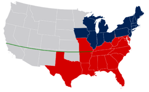
The parallel 36°30′ north is an imaginary line that goes around the Earth. It is located 36 and a half degrees north of the equator. This line is very important in the history of the United States. It was used as a key part of the Missouri Compromise. This agreement helped decide which new states joining the U.S. would allow slavery and which would not. The line mostly divided slave and free states west of the Mississippi River, except for Missouri itself, which was mostly north of this line.
Contents
What is a Parallel?
A parallel, also called a circle of latitude, is an imaginary line that circles the Earth. These lines run east to west, parallel to the equator. They help us measure how far north or south a place is. The equator is at 0 degrees latitude. The North Pole is at 90 degrees north, and the South Pole is at 90 degrees south. The 36°30′ north parallel is just one of these many lines.
The Missouri Compromise Explained
The Missouri Compromise was a special agreement made in 1820. It was created to solve a big problem in the United States: whether new states joining the country would allow slavery. At the time, there was a balance between states that allowed slavery (slave states) and states that did not (free states). This balance was important for political power in the government.
When Missouri wanted to become a state, it caused a big debate. Most of Missouri was north of the 36°30′ parallel, but it wanted to be a slave state. To keep the balance, Congress made a deal.
How the Compromise Worked
The Missouri Compromise had three main parts:
- Missouri was allowed to join the U.S. as a slave state.
- Maine joined the U.S. as a free state. This kept the number of slave and free states equal.
- A line was drawn at 36°30′ north latitude. This line would decide the future of slavery in new territories. Any new state created north of this line (except Missouri) would be a free state. Any new state south of this line could choose to allow slavery.
Why Was This Line Important?
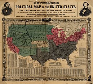
The 36°30′ parallel became a very important boundary. It showed a clear division between areas where slavery was allowed and where it was not. This line helped avoid bigger conflicts for a while. It was a temporary solution to a problem that eventually led to the American Civil War.
The compromise tried to keep peace between the North and the South. However, it did not solve the issue of slavery forever. Later, new laws like the Kansas–Nebraska Act in 1854 changed these rules. This act allowed people in new territories to decide for themselves if they wanted slavery. This led to more fighting and eventually contributed to the Civil War.
So, the 36°30′ parallel is more than just a line on a map. It represents a key moment in American history. It shows the deep divisions over slavery that shaped the country.
 | Shirley Ann Jackson |
 | Garett Morgan |
 | J. Ernest Wilkins Jr. |
 | Elijah McCoy |


