Paramount-Long Meadow, Maryland facts for kids
Quick facts for kids
Paramount-Long Meadow, Maryland
|
|
|---|---|

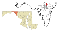
Location of Paramount-Long Meadow, Maryland
|
|
| Country | United States |
| State | Maryland |
| County | Washington |
| Area | |
| • Total | 2.18 sq mi (5.65 km2) |
| • Land | 2.18 sq mi (5.65 km2) |
| • Water | 0.00 sq mi (0.00 km2) |
| Elevation | 610 ft (190 m) |
| Population
(2020)
|
|
| • Total | 2,658 |
| • Density | 1,218.15/sq mi (470.33/km2) |
| Time zone | UTC−5 (Eastern (EST)) |
| • Summer (DST) | UTC−4 (EDT) |
| ZIP code |
21742
|
| Area code(s) | 240 and 301 |
| FIPS code | 24-59787 |
| GNIS feature ID | 2389639 |
Paramount-Long Meadow is a special kind of community in Washington County, Maryland, USA. It is called a "census-designated place" (CDP). This means it is a recognized area for counting people, even though it is not an official town or city. In 2020, about 2,658 people lived here.
Contents
Geography of Paramount-Long Meadow
This community covers a total area of about 2.18 square miles (5.65 square kilometers). All of this area is land, with no large bodies of water.
History of Long Meadow
The area now known as Long Meadow in Washington County, Maryland, was once a large, mostly flat farming region. It covered nearly twenty square miles west of Antietam Creek.
Early Transportation and Settlers
One of the first travel routes through the colony passed close to this region. It crossed the upper parts of Antietam Creek before turning southwest. Many early German and Swiss immigrants used this route. They were moving to the Hagerstown area from central Pennsylvania.
Origin of the Name
The name "Long Meadow" comes from a land grant given to Thomas Cresap (Sr.) in 1739. In 1746, Cresap's Long Meadow property was sold to Daniel Dulaney, an investor from Annapolis. The property grew from 550 acres to 2,131 acres.
Agricultural Roots and Modern Development
The "Long Meadow" area stayed mostly farmland until the middle of the 20th century. In 1958, the name was used again when the first modern shopping area opened. This was the "Long Meadow Shopping Center," located between Northern Avenue and Potomac Avenue / Leitersburg Pike.
People of Paramount-Long Meadow
| Historical population | |||
|---|---|---|---|
| Census | Pop. | %± | |
| 2020 | 2,658 | — | |
| U.S. Decennial Census | |||
In 2000, there were 2,722 people living in Paramount-Long Meadow. The population density was about 980 people per square mile (378 people per square kilometer).
Community Makeup
Most residents were White (about 93.6%). There were also African American (2.46%), Asian (2.42%), and Native American (0.18%) residents. About 0.84% of the population was Hispanic or Latino.
Households and Families
There were 985 households in the area. About 32% of these households had children under 18 living with them. Most households (69.4%) were married couples living together.
Age Distribution
The population was spread out across different age groups. About 23.2% of residents were under 18 years old. About 21.7% were 65 years or older. The average age in the community was 45 years.
See also
 In Spanish: Paramount-Long Meadow para niños

