Parishes of Dominica facts for kids
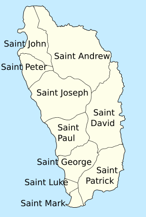
Dominica is a beautiful island country located in the Caribbean Sea. To help manage the country and its communities, Dominica is divided into ten smaller areas. These areas are called parishes. You can think of them like counties or states in other countries. Each parish helps organize local services and government for the people who live there.
What are Parishes?
Dominica has ten parishes, and each one is named after a saint. These parishes help the government keep things running smoothly across the island. For example, they help manage schools, roads, and other important services for local communities. Dividing the country into smaller parts makes it easier to look after everyone.
The capital city of Dominica, Roseau, is located in the Saint George Parish. This parish is also the most populated one on the island.
The Ten Parishes of Dominica
Here is a list of the ten parishes in Dominica, along with their population from the 2011 census, their land area, and how many people live per square kilometer (population density).
| Name | Population (2011) |
Land area | Population density |
|---|---|---|---|
| Saint Andrew | 9,471 | 179.9 km2 (69.5 sq mi) | 52.6 per km² |
| Saint David | 6,043 | 125.8 km2 (48.6 sq mi) | 48.0 per km² |
| Saint George | 21,241 | 56.2 km2 (21.7 sq mi) | 378.0 per km² |
| Saint John | 6,561 | 59.1 km2 (22.8 sq mi) | 111.0 per km² |
| Saint Joseph | 5,637 | 118.4 km2 (45.7 sq mi) | 47.6 per km² |
| Saint Luke | 1,668 | 10.8 km2 (4.2 sq mi) | 154.4 per km² |
| Saint Mark | 1,834 | 13.5 km2 (5.2 sq mi) | 135.9 per km² |
| Saint Patrick | 7,622 | 86.7 km2 (33.5 sq mi) | 87.9 per km² |
| Saint Paul | 9,786 | 66.4 km2 (25.6 sq mi) | 147.4 per km² |
| Saint Peter | 1,430 | 34.2 km2 (13.2 sq mi) | 41.8 per km² |
 | James Van Der Zee |
 | Alma Thomas |
 | Ellis Wilson |
 | Margaret Taylor-Burroughs |


