
Parks and open spaces in Liverpool facts for kids
Liverpool, a famous city in England, has many amazing public parks and gardens. Experts say that the city's collection of is the "most important in the country." Liverpool has 10 parks and cemeteries that are officially "listed," meaning they are very special. Two of these are Grade I (the highest level), and five are Grade II*. This is more than any other UK city except London. In total, the city has over 2,500 acres (about 10 square kilometers) of parks and open spaces.
For a long time, most of these open spaces were private land belonging to large estates. Many grand houses from the Georgian era and Victorian era are now gone or owned by the public. Their gardens and grounds have become city parks. However, some parks were planned from the very beginning to be public. These were partly inspired by Birkenhead Park, which was one of the first parks of its kind in the world.
Contents
Why Parks Are Important
In 1833, the government created a special group called the Select Committee on Public Walks. This group said that cities needed to have easy-to-reach places for people to relax and play. They believed this would make city residents healthier, reduce arguments between different groups, and help people from all social classes mix.
From the early 1850s, Liverpool agreed with this idea. The city invested a lot of money to create a ring of large public parks. These included well-known parks like Princes Park, Sefton Park, Wavertree Botanic Park, Shiel Park, Newsham Park, and Stanley Park.
Exploring Liverpool's Parks
Liverpool has many wonderful parks and green spaces. Here are some of the most interesting ones:
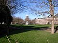
- Abercromby Square
- This square was built around 1820. The buildings around it are now part of the University of Liverpool.
- Allerton Cemetery
- Opened in 1909, this cemetery is part of the old Allerton Hall estate. It has three stone chapels with tall steeples. It covers about 34 hectares.
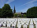
- Anfield Cemetery
- This large cemetery was built between 1861 and 1864 because other cemeteries were full. It covers about 57 hectares.
- Calderstones Park
- This park grew from the grounds of Calderstones House, built around 1828. The grounds became a park in 1913. It covers about 38 hectares.

- Camphill and Woolton Woods
- This park was made from the gardens of two houses, Camp Hill (now gone) and Woolton Hall. It has a special walled garden and a unique floral cuckoo clock. It covers about 30 hectares.

- Croxteth Country Park
- This huge country park surrounds Croxteth Hall, which was once home to the Earls of Sefton. It has a walled garden and a working farm. It covers about 203 hectares.
- Everton Park
- Created in the early 1980s, this park is on Everton Hill, the highest point in the city. It offers great views of Liverpool. It has a walled garden and two small lakes.

- Falkner Square
- This was one of Liverpool's first public open spaces, existing by 1831. Houses around the square were built in the 1840s.

- Greenbank Park
- The main feature of this park is a lake where you can fish. It also has a playground, a walled garden, and a special area for graffiti art.

- Newsham Park
- This park was designed by Edward Kemp from the grounds of Newsham House. It has two lakes, a bandstand, and play areas. It covers about 48 hectares.

- Princes Park
- This was Liverpool's very first public park, designed by Joseph Paxton. It has a fishing lake and play areas for children. It covers about 28 hectares.
- Reynolds Park
- This park was created from the grounds of Reynolds Park Mansion, which burned down in 1921. It features a walled garden, a wildflower meadow, and a unique sunken garden. It covers about 6 hectares.
- Sefton Park
- This is a very large and famous park. It has a beautiful Palm House, the Shaftesbury memorial and Eros fountain, a Peter Pan statue, a boating lake, and cafes. It covers about 82 hectares.

- Stanley Park
- Designed by Edward Kemp, this park was laid out between 1867 and 1871. It has the Isla Gladstone Conservatory, lakes, a bandstand, and play areas. It covers about 46 hectares.
.jpg)
- St James Gardens
- Located next to Liverpool Cathedral, these gardens are in a sunken area that used to be a quarry and then a cemetery. It covers about 4 hectares.
- St John's Gardens
- Next to St George's Hall in the city center, these gardens opened in 1904. They have formal gardens and statues of important Liverpool figures.

- St Nicholas Church Gardens
- The old churchyard of St Nicholas' Church became a garden in 1891. It has a memorial for those who died in the Liverpool Blitz during World War II.

- Toxteth Park and Cemetery
- This was the first cemetery in Liverpool created under a special law in 1857. It covers about 16 hectares.

- Wavertree Botanic Garden and Park
- The botanic gardens were started by William Roscoe in 1836. The land next to it became a park ten years later. The glasshouses were destroyed in World War II, but the walled garden is still there. It covers about 14.6 hectares.

Most of these parks are always open and free to enter. The only exception is the walled botanic garden in Wavertree Park, which has specific opening hours.
Croxteth Country Park: A Working Estate
Croxteth Hall and Country Park is managed by Liverpool City Council. This park is a great example of a working country estate. It features the historic Hall itself, surrounded by old woodlands. You can also see a collection of rare farm animals at the traditional "Home Farm" and visit a Victorian walled garden. The Hall is a Grade II* listed building, and the Park is Grade II listed.
Learning About Parks
Experts from the University of Liverpool have studied the history of parks and open spaces in the city. They look at how parks have changed over the last 200 years. They also study how parks can help communities, education, nature (biodiversity), public health, and city improvements today. Their research will show how important parks have been, from the Victorian era to now.
Images for kids
-
Abercromby Square
-
Allerton Cemetery
-
Anfield Cemetery


