Partoun, Utah facts for kids
Quick facts for kids
Partoun, Utah
|
|
|---|---|

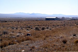
View to the southeast showing Partoun and West Desert High School
|
|
| Country | United States |
| State | Utah |
| County | Juab |
| Founded | 1949 |
| Named for | A Scottish town |
| Elevation | 4,800 ft (1,463 m) |
| GNIS feature ID | 1437285 |
Partoun is a small community in Juab County, Utah, United States. It's located in a wide valley called Snake Valley. Partoun was started in 1949 by a religious group called the Aaronic Order, and it got its name from a town in Scotland. It's considered an unincorporated community, which means it's not officially a city or town with its own local government.
Discovering Partoun, Utah
Partoun is found in the western part of Utah. It sits at an elevation of about 4,818 feet (1,469 meters) above sea level. This community is part of the larger Provo–Orem area, which is a big group of cities and towns in Utah.
The Story of Partoun
Partoun was founded in 1949. It was started by a religious group known as the Aaronic Order. They named the community after a town in Scotland. This shows how places can get their names from other parts of the world.
Schools in Partoun
Even though Partoun is a small community, it's home to two important schools. These are West Desert High School and West Desert Elementary School. These schools serve the students living in Partoun and the surrounding areas. Sometimes, their websites might mention a nearby community called Trout Creek, which is to the north.
Partoun's Weather
Partoun experiences a variety of weather throughout the year. The warmest month is usually July, and the coldest is January. The area gets some rain and snow, especially in the winter months. You can see more details about the average temperatures and precipitation in the table below.
| Climate data for Partoun, Utah (Elevation 4,800ft) | |||||||||||||
|---|---|---|---|---|---|---|---|---|---|---|---|---|---|
| Month | Jan | Feb | Mar | Apr | May | Jun | Jul | Aug | Sep | Oct | Nov | Dec | Year |
| Record high °F (°C) | 69 (21) |
74 (23) |
82 (28) |
92 (33) |
100 (38) |
105 (41) |
107 (42) |
105 (41) |
100 (38) |
93 (34) |
78 (26) |
67 (19) |
107 (42) |
| Mean daily maximum °F (°C) | 40.4 (4.7) |
46.6 (8.1) |
55.9 (13.3) |
64.4 (18.0) |
74.4 (23.6) |
85.5 (29.7) |
94.4 (34.7) |
92.0 (33.3) |
82.2 (27.9) |
68.2 (20.1) |
52.4 (11.3) |
41.3 (5.2) |
66.5 (19.2) |
| Mean daily minimum °F (°C) | 13.7 (−10.2) |
19.4 (−7.0) |
25.8 (−3.4) |
32.4 (0.2) |
40.5 (4.7) |
48.7 (9.3) |
56.1 (13.4) |
54.3 (12.4) |
44.0 (6.7) |
33.2 (0.7) |
22.8 (−5.1) |
14.7 (−9.6) |
33.8 (1.0) |
| Record low °F (°C) | −23 (−31) |
−29 (−34) |
−2 (−19) |
10 (−12) |
16 (−9) |
21 (−6) |
36 (2) |
31 (−1) |
21 (−6) |
2 (−17) |
−7 (−22) |
−27 (−33) |
−29 (−34) |
| Average precipitation inches (mm) | 0.42 (11) |
0.50 (13) |
0.54 (14) |
0.72 (18) |
0.94 (24) |
0.69 (18) |
0.56 (14) |
0.57 (14) |
0.58 (15) |
0.61 (15) |
0.46 (12) |
0.35 (8.9) |
6.93 (176) |
| Average snowfall inches (cm) | 3.3 (8.4) |
3.4 (8.6) |
0.8 (2.0) |
0.7 (1.8) |
0.1 (0.25) |
0 (0) |
0 (0) |
0 (0) |
0 (0) |
0.3 (0.76) |
0.8 (2.0) |
1.9 (4.8) |
11.4 (29) |
| Source: The Western Regional Climate Center | |||||||||||||
 | Mary Eliza Mahoney |
 | Susie King Taylor |
 | Ida Gray |
 | Eliza Ann Grier |


