Patía, Cauca facts for kids
Quick facts for kids
Patia, Cauca
|
||
|---|---|---|
|
Municipality and town
|
||
|
||

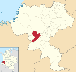
Location of the municipality and town of Patia, Cauca in the Cauca Department of Colombia.
|
||
| Country | ||
| Department | Cauca Department | |
| Elevation | 723 m (2,372 ft) | |
| Population
(2020 est.)
|
||
| • Total | 37,781 | |
| Time zone | UTC-5 (Colombia Standard Time) | |
| Climate | Am | |
Patía is a cool municipality and town in the Cauca Department of Colombia. Its main town, where the local government is, is called El Bordo.
Patía is known for its amazing natural beauty and fun places to visit. You can explore spots like Piedra Sentada, the Parador Patía, and the Lerma Hill. The Patía river flows through this area, making the valley green and fertile. This river is super important because it's the biggest and most powerful river in the South American Pacific region.
You can find Patía right on the Pan-American Road. It's about 82 kilometers (or 51 miles) south of Popayán, which is the capital city of the Cauca Department.
Contents
Patía's Past: A Look at Its History
The Patía Valley has been home to people for a very long time, even before Europeans arrived. Native groups like the Bojoles, Chapa Chugas, Sindaguas, and Patias lived here. Later, many enslaved people were brought to work on farms and in gold mines along the Patía River. These people created new towns called palenques, which were places where they could live freely.
There's a cool local story about how a lake was formed. It says that after some people escaped slavery, they climbed Manzanillo Hill. They hoped to see their home in Africa, but they couldn't. They cried so much that their tears filled a lake! Today, you can visit this mythical spot on Manzanillo Hill, where water still flows into the Valerio ravine.
People in the past also dug for gold in a place called The Hoyo. This area is near the Quilcacé River and Esmita, where coal is still mined by hand today.
Exploring Patía's Geography
The Patía Valley includes several towns and areas like El Bordo, Patía, Mercaderes, and the smaller communities of Galindez, Mojarras, and Pilón.
The middle part of the Patía River flows through a special area called the Patía Valley dry forests. This ecoregion has unique plants and animals.
The valley itself is surrounded by the western and central mountain ranges. The Patía River flows from north to south through this valley, even reaching into the Nariño department.
Patía is in the southern part of the Cauca department. It takes about 4 to 6 hours to drive there from Popayán. The valley is located between the Guachicono, San Jorge, and Mama Conde rivers, which all flow into the Patía River. The Manzanillo Hill stands tall, watching over the valley's beautiful plains.
El Bordo: Patía's Main Town
El Bordo is the main town of the Patía municipality. It's located at 2° 06' 56" north and 76° 59' 21" west. It sits about 910 meters (or 2,986 feet) above sea level. The average temperature here is around 23°C (or 73.4°F). The municipality covers an area of about 732 square kilometers (or 283 square miles).
Patía shares its borders with other municipalities:
- To the north: The Tambo and The Sierra
- To the east: Bolívar and The Sierra
- To the south: Sucre and Mercaderes
- To the west: Balboa and Argelia
Many smaller communities are part of Patía, including Tha Hoyo, The Fonda or Portugal, The Tallas, Mendez, Pan de Azúcar, Angulo, Bello Horizonte, Brisas, Santacruz, Don Alonso, The Estrecho, The Placer, The Puro, Galindez, The Mesa, Piedra Sentada, and Santa Rosa Baja. Together, these areas make up about 755 square kilometers (or 292 square miles).
- Urban area: 22.24 square kilometers (or 8.59 square miles)
- Rural area: 732.76 square kilometers (or 282.92 square miles)
Mercaderes: A Neighboring Area
Mercaderes is another important area in the Patía Valley.
Its borders are:
- To the north: Patía and Balboa
- To the east: Bolívar
- To the west: Nariño department, Leyva, and The Rosario
- To the south: Florencia and Nariño department, Taminango, San Lorenzo, and La Unión
Mercaderes has a total area of about 641.009 square kilometers (or 247.5 square miles). It is about 1,167 meters (or 3,829 feet) above sea level, and its average temperature is around 22°C (or 71.6°F).
Patía's Climate: What's the Weather Like?
| Climate data for Patía (Fonda La Citec), elevation 635 m (2,083 ft), (1981–2010) | |||||||||||||
|---|---|---|---|---|---|---|---|---|---|---|---|---|---|
| Month | Jan | Feb | Mar | Apr | May | Jun | Jul | Aug | Sep | Oct | Nov | Dec | Year |
| Mean daily maximum °C (°F) | 32.2 (90.0) |
32.8 (91.0) |
32.8 (91.0) |
32.5 (90.5) |
32.4 (90.3) |
32.9 (91.2) |
34.2 (93.6) |
35.4 (95.7) |
35.2 (95.4) |
33.0 (91.4) |
31.4 (88.5) |
31.4 (88.5) |
33.0 (91.4) |
| Daily mean °C (°F) | 26.0 (78.8) |
26.2 (79.2) |
26.2 (79.2) |
25.9 (78.6) |
25.9 (78.6) |
25.9 (78.6) |
26.7 (80.1) |
27.6 (81.7) |
27.4 (81.3) |
26.3 (79.3) |
25.6 (78.1) |
25.5 (77.9) |
26.3 (79.3) |
| Mean daily minimum °C (°F) | 20.7 (69.3) |
20.6 (69.1) |
20.7 (69.3) |
21.2 (70.2) |
20.9 (69.6) |
20.1 (68.2) |
18.0 (64.4) |
18.9 (66.0) |
19.0 (66.2) |
20.3 (68.5) |
20.7 (69.3) |
20.9 (69.6) |
20.1 (68.2) |
| Average precipitation mm (inches) | 172.1 (6.78) |
164.3 (6.47) |
197.4 (7.77) |
193.6 (7.62) |
167.3 (6.59) |
68.7 (2.70) |
38.0 (1.50) |
39.7 (1.56) |
113.4 (4.46) |
249.4 (9.82) |
263.6 (10.38) |
247.0 (9.72) |
1,914.5 (75.37) |
| Average precipitation days | 15 | 12 | 15 | 16 | 14 | 9 | 5 | 5 | 9 | 17 | 20 | 19 | 19 |
| Average relative humidity (%) | 77 | 77 | 77 | 79 | 78 | 77 | 68 | 63 | 66 | 74 | 79 | 79 | 74 |
| Mean monthly sunshine hours | 186.0 | 158.1 | 161.2 | 153.0 | 164.3 | 177.0 | 201.5 | 201.5 | 168.0 | 170.5 | 162.0 | 179.8 | 2,082.9 |
| Mean daily sunshine hours | 6.0 | 5.6 | 5.2 | 5.1 | 5.3 | 5.9 | 6.5 | 6.5 | 5.6 | 5.5 | 5.4 | 5.8 | 5.7 |
| Source: Instituto de Hidrologia Meteorologia y Estudios Ambientales | |||||||||||||
Patía has a warm climate. The average temperature is around 26.3°C (79.3°F) throughout the year. It gets a lot of rain, especially from October to January. The driest months are July and August. Even with the rain, there's still plenty of sunshine!
How to Get to the Patía Valley
To reach the beautiful Patía Valley, you'll travel through the municipalities of Timbio and Rosas. You'll pass through small towns like Piedrasentada and El Mango. Finally, you'll arrive at El Bordo, which is where the Patía Valley officially begins.
If you keep going for about 30 minutes, you'll reach Patía itself. This area is famous for its totumo's koumis (a local drink) and watermelons! After Patía, you'll find Galindez and Pilón.
If you continue on the Pan-American highway, you'll get to El Estrecho. From here, you can choose to go towards Balboa – Cauca, which is known as “The Patía Balcony.” Or, you can head towards Mojarras, another lovely part of the Patía Valley. In Mojarras, you can decide to keep going south into the Nariño department, or turn off to reach Mercaderes – Cauca, which is the last stop in the valley.
Patía Valley Culture: Music, Dance, and Stories

The culture in the Patía Valley is all about dance, music, and theater! It's a very rich and lively place for music in the Cauca region. The Patía Valley is known as the birthplace of a special type of music called Bambuco.
The Patiano Bambuco is more than just music; it's a whole performance! People play instruments, sing, dance, and even act out stories. It has a unique rhythm and often tells tales about everyday life. These songs can be funny, ironic, or even critical about things that affect the community. They talk about weddings, food, love, government, health issues, and local problems. Both adults and children enjoy performing and dancing to this music.
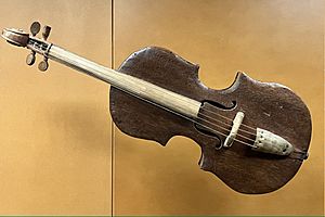
What makes Patiano Bambuco even more special is that it uses local instruments. These include the violin patiano, the charango, and the charrasca. The charrasca is made from the totumo fruit, which grows all over the region. This fruit is also important for the local economy, as many women collect it to support their families.
See also
 In Spanish: Patía para niños


