
Peñasco, New Mexico facts for kids
Quick facts for kids
Peñasco, New Mexico
|
|
|---|---|

Church in Peñasco, 1943
|
|

Location of Peñasco, New Mexico
|
|

Peñasco, New Mexico
Location in the United States
|
|
| Country | United States |
| State | New Mexico |
| County | Taos |
| Area | |
| • Total | 1.22 sq mi (3.15 km2) |
| • Land | 1.22 sq mi (3.15 km2) |
| • Water | 0.00 sq mi (0.00 km2) |
| Elevation | 7,645 ft (2,330 m) |
| Population
(2020)
|
|
| • Total | 474 |
| • Density | 389.80/sq mi (150.48/km2) |
| Time zone | Mountain (MST) |
| ZIP Code |
87553
|
| Area code(s) | 575 |
| FIPS code | 35-55900 |
| GNIS feature ID | 2409051 |
Peñasco is a small community in Taos County, New Mexico. It is known as a census-designated place (CDP), which means it's an area identified by the U.S. Census Bureau for statistical purposes. Peñasco is located along the beautiful High Road to Taos, a popular scenic route. In 2020, about 474 people lived there.
Geography
Peñasco covers an area of about 1.2 square miles (3.1 square kilometers). All of this area is land, with no water bodies within its borders.
Population and People
| Historical population | |||
|---|---|---|---|
| Census | Pop. | %± | |
| 2020 | 474 | — | |
| U.S. Decennial Census | |||
In 2020, the population of Peñasco was 474 people. This means there were about 150 people living in each square kilometer of the area. Most people in Peñasco have a Hispanic or Latino background.
Education
The schools in Peñasco are part of the Peñasco Independent School District.
Images for kids
-
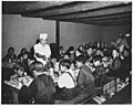
Students enjoying hot lunch at Peñasco school, 1941
-
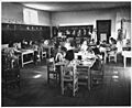
A lower grade classroom in Peñasco school
-
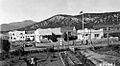
Peñasco Ranger Station, 1932


See also
 In Spanish: Peñasco (Nuevo México) para niños
