
Perth Lade facts for kids
Quick facts for kids Perth Lade |
|
|---|---|

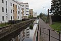
The lade near St. Catherine's Retail Park in Perth city centre
|
|

Location of Perth Lade
|
|
| Country | Scotland |
| County | Perth and Kinross |
| Towns | Huntingtower and Ruthvenfield Tulloch Perth |
| Physical characteristics | |
| Main source | Low's Work (River Almond) 52.5 m (172 ft) 56°24′50″N 3°30′32″W / 56.4139557°N 3.50878°W |
| River mouth | River Tay Perth 14.0 m (45.9 ft) 56°23′54″N 3°25′36″W / 56.398323°N 3.426616°W |
| Length | 4.5 mi (7.2 km) |
| Basin features | |
| River system | River Almond |
The Perth Lade is an old water channel in Perth and Kinross, Scotland. It's about 4.5 miles long. People sometimes call it a "mill race" because it was built to power watermills.
This special watercourse was created way back in the 12th century. It helped run many mills, like the ones at Perth's Lower City Mills. These mills have been around since the 1700s! Over time, at least nineteen different factories and workshops used the lade's power. Today, you can still see parts of nine of these old sites. The others have been covered by new buildings and homes. A walking path follows most of the lade's journey, so you can explore it yourself.
Contents
The Lade's Journey
The Perth Lade starts at a place called Low's Work, on the River Almond. This is west of Huntingtower, which is northwest of Perth city centre. At its start, the lade is about 52.5 meters above sea level. Here, a special wall called a weir helps control the water flow from the river into the lade.
Through Huntingtower and Ruthvenfield
First, the lade flows northeast for a short distance. Then it turns southeast and goes under a road called Bleachers Way in Huntingtower. It quickly passes under three more streets. After that, it turns northeast again near Castle Brae. About 700 feet later, it turns southeast as it enters Ruthvenfield. While running next to Castle Brae, it flows under Ruthvenfield Road.
For about 500 feet, the lade goes underground. It comes out again just after a street named Ruthven Lade.
Towards Perth City Centre
The lade continues southeast for about 450 feet. It then turns east as it gets close to the roads that connect the A85 Crieff Road and the A9 motorway. It flows under these busy roads. After that, it runs north of McDiarmid Park (a football stadium) and Perth Crematorium. If you're walking along the lade, you'll cross the Inveralmond Skywalk Footbridge around this area.
It keeps going east for about 1,500 feet, reaching Tulloch. Here, it curves around the northern part of Primrose Crescent and goes behind Tulloch Primary School.
Near the Railway
The lade then passes through the area where J. Pullar and Sons used to have a dyeworks (a factory for dyeing cloth). This is north of Sandeman Court and Bracken Brae. Its path then turns south as it meets the railway lines. It loops west around the railway sidings (where trains are parked). It also crosses the edge of Kinnoull F.C.'s Tulloch Park football ground.
As the lade gets closer to Crieff Road, it turns east again. It goes under the railway line, where there's a footbridge for people to cross. It then loops around the old location of Jeanfield Swifts F.C.'s Simpson Park football ground.
Final Stretch to the River Tay
The lade passes under Crieff Road just east of Collinson View. It then continues for about 2,600 feet into the heart of Perth city centre. It flows under Caledonian Road and the St. Catherine's Retail Park. Finally, it finishes its journey underground, flowing beneath Mill Street from Lower City Mills to Tay Street. Here, it empties into the River Tay, which is Scotland's longest river. This happens from the lade's western bank near Smeaton's Bridge, at an elevation of about 14.0 meters above sea level.
Gallery
-
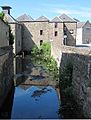
Perth Lade running beneath Lower City Mills, looking west (upstream), before it continues under Mill Street for the remaining 0.3 miles of its journey
.jpg)
Images for kids
-
The lade near St. Catherine's Retail Park in Perth city centre
-
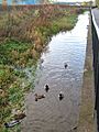
A stretch of the lade near Monart Road, looking south

