Peñón de Ponce facts for kids
Quick facts for kids Peñón de Ponce |
|
|---|---|
| Highest point | |
| Elevation | 335 ft (102 m) |
| Prominence | 335 ft (102 m) |
| Geography | |
| Location | Ponce, Puerto Rico |
| Climbing | |
| Easiest route | PR-2, km 220.1, Sector Las Cucharas, Barrio Canas, Ponce, Puerto Rico |
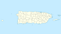
Peñón de Ponce is a large rock or small hill in Ponce, Puerto Rico. It is located on the western coast of the area. You can find it near a place called Sector Punta Cucharas in Barrio Canas. This rock sits just north of Puerto Rico Highway 2 (PR-2) at kilometer 220.1. Peñón de Ponce is important because it separates the Port of Tallaboa from the flat lands that lead into the city of Ponce.
History of Peñón de Ponce
People have known about Peñón de Ponce for a very long time. Records show it was mentioned as early as 1788. A person named Íñigo Abbad used it as a famous spot. He noted it was about two "leguas" from the village of Ponce. A "legua" was an old way to measure distance, like a 2-hour walk. This shows how important the rock was for finding your way around.
Location and What It's Made Of
Peñón de Ponce is found at specific map points: 17° 58' 47.5" North and -66° 41' 54.5" West. The area around the hill is known for its valuable limestone. Limestone is a type of rock used to make cement. There is also a hotel nearby on one of the neighboring hills.
Peñón de Ponce in Art
In 1855, a poet named Federico Matos wrote a short poem about this hill. The poem was called "En el Peñón de Ponce" (which means "On the Peñón de Ponce"). It was printed in a newspaper called El Fénix in Ponce in 1858. The poem was written for Matos's friend, Martin Travieso.
 | Percy Lavon Julian |
 | Katherine Johnson |
 | George Washington Carver |
 | Annie Easley |


