Quick facts for kids
Piccadilly
|
Colour on map |
Dark blue |
Year opened |
1906 |
Line type |
Deep Tube |
Rolling stock |
1973 tube stock
6 cars per trainset |
Stations served |
53 |
Length |
71 km (44 mi) |
Depots |
Cockfosters
Northfields |
Journeys made |
176,177,000 |
|
The Piccadilly line is a line of the London Underground. It is coloured dark blue on the Tube map. It is the fifth busiest line on the Underground network judged by the number of passengers transported per year. It is mainly a deep-level line, running from the north to the west of London via Zone 1. However, there are a number of surface sections mostly in its westernmost parts. Out of the 53 stations served, 25 are underground. It is the second longest line on the system, after the Central Line.
Infrastructure
Rolling stock
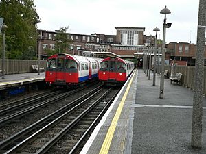
Piccadilly line trains of 1973 stock at Rayners Lane station
Like most Underground lines, the Piccadilly line is operated by a single type of rolling stock. In this case it is the 1973 tube stock. The trains are painted in the standard London Underground livery of blue, white and red. Seventy-six trains out of a fleet of 88 are needed to run the line's peak service. One unit (166-566-366) was severely damaged by the terrorist attack of 7 July 2005. The stock was recently refurbished, and was due for replacement by 2014, but the order for new trains was cancelled in July 2010.
The line was previously worked by 1959 stock, 1956 stock, 1938 stock, standard tube stock and 1906 gate stock.
The line has two depots, at Northfields and Cockfosters. There are sidings at Oakwood, South Harrow, Arnos Grove, Rayners Lane, Down Street, Wood Green, Acton Town, Ruislip and Uxbridge.
Signalling
The line is controlled from the control centre at Earl's Court, which it used to share with the District line. It is in need of resignalling, and this work is planned to be carried out by 2014.
Service pattern
The current off-peak service pattern is:
- 6 trains per hour Cockfosters – Heathrow Terminal 5 (via Terminals 1, 2, 3)
- 6 trains per hour Cockfosters – Heathrow Terminal 4 (returning around the loop and serving Terminals 1, 2, 3)
- 3 trains per hour Cockfosters – Uxbridge
- 3 trains per hour Cockfosters – Rayners Lane
- 6 trains per hour Arnos Grove – Northfields
Often late evening services terminate at Oakwood instead of Cockfosters.
Trains will also make an additional stop at Turnham Green during early mornings and late evenings but will not stop at the station during the main part of the day.
Other services operate at times, especially at the start and towards the end of the traffic day.
Map
Easier Versions can be found http://www.tfl.gov.uk/assets/downloads/standard-tube-map.gif
Closed stations
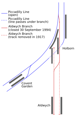
- Aldwych opened on 30 November 1907 as the Strand tube station. It was at the end of a branch line from the main line at Holborn. An evening through-northbound 'Theatre' train ran until 1910. From 1917 onwards, it was served only by a shuttle from Holborn. In the same year it was renamed Aldwych when Charing Cross on the Northern line was renamed Strand. It was temporarily closed in 1940 during World War II to be used as an air-raid shelter. It re-opened in 1946. The possibility of extending the branch to Waterloo was discussed, but the scheme never proceeded. Aldwych was finally closed on 30 September 1994; the level of use was said to be too low to justify the £1 million in estimated costs of a complete replacement of the lifts. The station is regularly used by film makers.
- Brompton Road opened 15 December 1906; closed 30 July 1934, between Knightsbridge and South Kensington.
- Down Street opened 15 December 1906; closed 21 May 1932, between Green Park and Hyde Park Corner.
- Osterley & Spring Grove first served 13 March 1933; closed 24 March 1934 between Boston Manor and Hounslow East. It was replaced by Osterley.
- Park Royal & Twyford Abbey opened 23 June 1903; closed 5 July 1931. Although on the route of the current Piccadilly line, a short distance north of the present Park Royal station, it was never served by Piccadilly line trains. It was opened by the District line, the original operator of the line between Ealing Common and South Harrow, and was closed and replaced by the present Park Royal station before the Piccadilly line started running trains to South Harrow in 1932.
- York Road opened 15 December 1906; closed 19 September 1932, between King's Cross St Pancras and Caledonian Road. It has been suggested that this station may be reopened to serve new developments on the nearby Kings Cross railway lands, but this idea is not being progressed at present. The road the station served, 'York Road', has since been renamed 'York Way'.
Future
The Piccadilly line was to be upgraded in 2014–15 and would have had new trains as well as new signalling. This would have increased the line's capacity by some 24%. Bids for the rolling-stock order were submitted in 2008. However, after the acquisition of Tube Lines by Transport for London in June 2010, this order was cancelled.
Maps
- Cockfosters – 51°39′06″N 000°08′56″W / 51.65167°N 0.14889°W / 51.65167; -0.14889 (01 - Cockfosters tube station)
- Oakwood – 51°38′51″N 000°07′54″W / 51.64750°N 0.13167°W / 51.64750; -0.13167 (02 - Oakwood tube station)
- Southgate – 51°37′57″N 000°07′41″W / 51.63250°N 0.12806°W / 51.63250; -0.12806 (03 - Southgate tube station)
- Arnos Grove – 51°36′59″N 000°08′01″W / 51.61639°N 0.13361°W / 51.61639; -0.13361 (04 - Arnos Grove tube station)
- Bounds Green – 51°36′25″N 000°07′27″W / 51.60694°N 0.12417°W / 51.60694; -0.12417 (05 - Bounds Green tube station)
- Wood Green – 51°35′49″N 000°06′36″W / 51.59694°N 0.11000°W / 51.59694; -0.11000 (06 - Wood Green tube station)
- Turnpike Lane – 51°35′25″N 000°06′10″W / 51.59028°N 0.10278°W / 51.59028; -0.10278 (07 - Turnpike Lane tube station)
- Manor House – 51°34′15″N 000°05′46″W / 51.57083°N 0.09611°W / 51.57083; -0.09611 (08 - Manor House tube station)
- Finsbury Park – 51°33′53″N 000°06′23″W / 51.56472°N 0.10639°W / 51.56472; -0.10639 (09 - Finsbury Park station)
- Arsenal – 51°33′31″N 000°06′21″W / 51.55861°N 0.10583°W / 51.55861; -0.10583 (10 - Arsenal tube station)
- Holloway Road – 51°33′11″N 000°06′43″W / 51.55306°N 0.11194°W / 51.55306; -0.11194 (11 - Holloway Road tube station)
- Caledonian Road – 51°32′54″N 000°07′07″W / 51.54833°N 0.11861°W / 51.54833; -0.11861 (12 - Caledonian Road tube station)
- King's Cross St. Pancras – 51°31′49″N 000°07′27″W / 51.53028°N 0.12417°W / 51.53028; -0.12417 (13 - King's Cross St. Pancras tube station)
- Russell Square – 51°31′23″N 000°07′28″W / 51.52306°N 0.12444°W / 51.52306; -0.12444 (14 - Russell Square tube station)
- Holborn – 51°31′03″N 000°07′12″W / 51.51750°N 0.12000°W / 51.51750; -0.12000 (15 - Holborn tube station)
- Covent Garden – 51°30′47″N 000°07′27″W / 51.51306°N 0.12417°W / 51.51306; -0.12417 (16 - Covent Garden tube station)
- Leicester Square – 51°30′41″N 000°07′41″W / 51.51139°N 0.12806°W / 51.51139; -0.12806 (17 - Leicester Square tube station)
- Piccadilly Circus – 51°30′36″N 000°08′02″W / 51.51000°N 0.13389°W / 51.51000; -0.13389 (18 - Piccadilly Circus tube station)
- Green Park – 51°30′24″N 000°08′34″W / 51.50667°N 0.14278°W / 51.50667; -0.14278 (19 - Green Park tube station)
- Hyde Park Corner – 51°30′10″N 000°09′10″W / 51.50278°N 0.15278°W / 51.50278; -0.15278 (20 - Hyde Park Corner tube station)
- Knightsbridge – 51°30′06″N 000°09′39″W / 51.50167°N 0.16083°W / 51.50167; -0.16083 (21 - Knightsbridge tube station)
- South Kensington – 51°29′39″N 000°10′26″W / 51.49417°N 0.17389°W / 51.49417; -0.17389 (22 - South Kensington tube station)
- Gloucester Road – 51°29′41″N 000°10′59″W / 51.49472°N 0.18306°W / 51.49472; -0.18306 (23 - Gloucester Road tube station)
- Earl's Court – 51°29′29″N 000°11′41″W / 51.49139°N 0.19472°W / 51.49139; -0.19472 (24 - Earl's Court tube station)
- Barons Court – 51°29′26″N 000°12′49″W / 51.49056°N 0.21361°W / 51.49056; -0.21361 (25 - Barons Court tube station)
- Hammersmith – 51°29′39″N 000°13′30″W / 51.49417°N 0.22500°W / 51.49417; -0.22500 (26 - Hammersmith tube station)
- Turnham Green – 51°29′43″N 000°15′18″W / 51.49528°N 0.25500°W / 51.49528; -0.25500 (27 - Turnham Green tube station)
- Acton Town – 51°30′10″N 000°16′48″W / 51.50278°N 0.28000°W / 51.50278; -0.28000 (28 - Acton Town tube station)
|
- South Ealing – 51°30′04″N 000°18′26″W / 51.50111°N 0.30722°W / 51.50111; -0.30722 (29 - South Ealing tube station)
- Northfields – 51°29′58″N 000°18′51″W / 51.49944°N 0.31417°W / 51.49944; -0.31417 (30 - Northfields tube station)
- Boston Manor – 51°29′45″N 000°19′30″W / 51.49583°N 0.32500°W / 51.49583; -0.32500 (31 - Boston Manor tube station)
- Osterley – 51°28′53″N 000°21′08″W / 51.48139°N 0.35222°W / 51.48139; -0.35222 (32 - Osterley tube station)
- Hounslow East – 51°28′23″N 000°21′23″W / 51.47306°N 0.35639°W / 51.47306; -0.35639 (33 - Hounslow East tube station)
- Hounslow Central – 51°28′17″N 000°21′59″W / 51.47139°N 0.36639°W / 51.47139; -0.36639 (34 - Hounslow Central tube station)
- Hounslow West – 51°28′25″N 000°23′08″W / 51.47361°N 0.38556°W / 51.47361; -0.38556 (35 - Hounslow West tube station)
- Hatton Cross – 51°28′01″N 000°25′24″W / 51.46694°N 0.42333°W / 51.46694; -0.42333 (36 - Hatton Cross tube station)
- Heathrow Terminal 4 – 51°27′32″N 000°26′46″W / 51.45889°N 0.44611°W / 51.45889; -0.44611 (37 - Heathrow Terminal 4 tube station)
- Heathrow Terminals 1, 2, 3 – 51°28′16″N 000°27′07″W / 51.47111°N 0.45194°W / 51.47111; -0.45194 (38 - Heathrow Terminals 1, 2, 3 tube station)
- Heathrow Terminal 5 – 51°28′20″N 000°29′17″W / 51.47222°N 0.48806°W / 51.47222; -0.48806 (39 - Heathrow Terminal 5 station)
- Ealing Common – 51°30′37″N 000°17′17″W / 51.51028°N 0.28806°W / 51.51028; -0.28806 (40 - Ealing Common tube station)
- North Ealing – 51°31′03″N 000°17′19″W / 51.51750°N 0.28861°W / 51.51750; -0.28861 (41 - North Ealing tube station)
- Park Royal – 51°31′37″N 000°17′03″W / 51.52694°N 0.28417°W / 51.52694; -0.28417 (42 - Park Royal tube station)
- Alperton – 51°32′27″N 000°17′59″W / 51.54083°N 0.29972°W / 51.54083; -0.29972 (43 - Alperton tube station)
- Sudbury Town – 51°33′03″N 000°18′56″W / 51.55083°N 0.31556°W / 51.55083; -0.31556 (44 - Sudbury Town tube station)
- Sudbury Hill – 51°33′25″N 000°20′11″W / 51.55694°N 0.33639°W / 51.55694; -0.33639 (45 - Sudbury Hill tube station)
- South Harrow – 51°33′53″N 000°21′08″W / 51.56472°N 0.35222°W / 51.56472; -0.35222 (46 - South Harrow tube station)
- Rayners Lane – 51°34′31″N 000°22′17″W / 51.57528°N 0.37139°W / 51.57528; -0.37139 (47 - Rayners Lane tube station)
- Eastcote – 51°34′36″N 000°23′49″W / 51.57667°N 0.39694°W / 51.57667; -0.39694 (48 - Eastcote tube station)
- Ruislip Manor – 51°34′24″N 000°24′45″W / 51.57333°N 0.41250°W / 51.57333; -0.41250 (49 - Ruislip Manor tube station)
- Ruislip – 51°34′17″N 000°25′16″W / 51.57139°N 0.42111°W / 51.57139; -0.42111 (50 - Ruislip tube station)
- Ickenham – 51°33′43″N 000°26′31″W / 51.56194°N 0.44194°W / 51.56194; -0.44194 (51 - Ickenham tube station)
- Hillingdon – 51°33′14″N 000°27′00″W / 51.55389°N 0.45000°W / 51.55389; -0.45000 (52 - Hillingdon tube station)
- Uxbridge – 51°32′45″N 000°28′42″W / 51.54583°N 0.47833°W / 51.54583; -0.47833 (53 - Uxbridge tube station)
- Cockfosters Depot – 51°38′56″N 000°08′25″W / 51.64889°N 0.14028°W / 51.64889; -0.14028 (54 - Cockfosters Depot)
- Northfields Depot – 51°29′50″N 000°19′14″W / 51.49722°N 0.32056°W / 51.49722; -0.32056 (55 - Northfields Depot)
|
Images for kids
-
One of the ventilation panels at Wood Green station platforms.
-
Reconfiguration of tunnels and platforms at Finsbury Park
-
Inside a Piccadilly line carriage
-
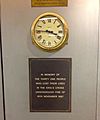
Memorial plaque of the King's Cross fire erected at the station itself.
-
-
Northfields Depot, with an S stock train.
-
A Metropolitan line train at Uxbridge, with a Piccadilly line train to the left. This section is shared between the two lines.
-
Notice found inside all Piccadilly line trains explaining step-free access
-
Notice found inside all Piccadilly line trains explaining alternative routes to Covent Garden
See also
In Spanish: Piccadilly Line para niños