Pidcock's Canal facts for kids
Quick facts for kids Pidcock's Canal |
|
|---|---|

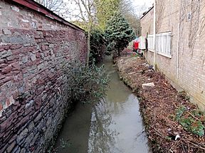
The remains of the Cut, to the north of Hill Street, Lydney
|
|
| Specifications | |
| Locks | 3 |
| Status | parts extant |
| History | |
| Date of first use | 1780s |
| Date closed | 1840 |
| Geography | |
| Start point | Middle Forge |
| End point | Lydney |
| Connects to | originally Lydney Pill; Lydney Canal from 1813 |
Pidcock's Canal was a waterway in Gloucestershire, England. It helped connect ironworks at Upper Forge and Lower Forge. The canal also reached an inlet from the River Severn called Lydney Pill.
Building of the canal started around 1778. It had three special water lifts, called locks, below Middle Forge. Later, in 1813, the Lydney Canal was built. Pidcock's Canal then connected to this new canal instead of Lydney Pill.
The canal stopped being used after 1840. By then, a horse-drawn tramway was built nearby. This tramway followed the valley of The Lyd. Today, this old tramway is part of the Dean Forest Railway. Most of Pidcock's Canal, often called The Cut, can still be seen today.
Contents
What Is the History of Pidcock's Canal?
Large areas around Lydney were part of a big estate. The Bathurst family managed this estate since 1723. They found many minerals there, like iron ore. To make money, they built ironworks. The Lower Forge ironworks used water from several streams. A long channel, called a leat, brought more water from the Newerne stream.
Who Built Pidcock's Canal?
In 1775, a man named David Tanner leased the Upper Forge. This forge was on the northern edge of Lydney. In 1778, he signed a new lease for 99 years. This agreement allowed him to build a canal from Upper Forge to Lower Forge.
We know the canal was finished by 1790. However, the exact year it was completed is not known. Tanner sold his lease in 1789. Then, in 1790, the Pidcock family bought it. They were glassmakers from Staffordshire.
How Did the Pidcock Family Use the Canal?
The Pidcocks ran the forges until 1813. They sold the lease back to the Bathurst family that year. The Pidcocks also had rights to mine coal. They used the canal to move coal to Lydney Pill.
When the lease ended, it included Upper and Middle Forges. It also covered the Lower Forge, a rolling mill, and the White Cross furnace. The canal, which now reached Lydney Pill, was also part of the lease.
John James took over the lease in 1814. He built another forge at New Mills in the 1820s. From 1844, he used the Lower Forge to make tinplate. In 1889, Richard Thomas improved the Lower Forge tinplate works. He had leased the works since 1876. After this, the other works were taken apart and left.
When Did the Canal Stop Being Used?
A tramway, the Lydney and Lydbrook Railway, was approved in 1809. This became the Severn and Wye Railway and Canal in 1810. Building a tramway and canal to Lydney Harbour started that same year.
The tramway ran next to Pidcock's Canal. It followed the Newerne Valley and crossed the canal twice. These crossings used special bridges that could be opened. Pidcock's Canal stopped being used in the 1840s.
Where Was Pidcock's Canal Located?
The canal began at the Upper Forge. It ran close to the Newerne stream, also known as The Lyd. The lower part of the canal went straight to the Lower Forge. It followed the path of an old leat that supplied water to the works.
There were three locks near the Middle works. The canal crossed the Chepstow road between Lydney and Newerne. The section from the Lower Forge to Lydney Pill was quite short.
How Did the Route Change Over Time?
Maps from 1880 show how the waterways looked then. The Upper Forge, New Mills, and Middle Forge all had large ponds. These ponds were upstream from the works and held back by stone dams.
After the canal closed, these ponds covered its route. This was especially true between Upper Forge and Middle Forge. Old maps show weirs and sluices at the ends of the ponds. The one at Middle Forge seemed to feed the canal.
By 1880, there was no clear way for boats to move between levels. There is no mention of locks for this purpose. At that time, the canal was known as The Cut.
From the Lower Mill, the canal used to go to Lydney Pill. But the waterways changed when the Lydney Canal was built. The 1880 map shows two channels below the Lower Mill. One clearly joined the bottom of The Lyd. This then flowed into the Lydney Canal. The other channel ran from a water storage area to a wide basin. This basin was near the Lydney Canal. However, there was no clear connection between these two channels. A small branch off this section ended near Station Road Cottages.
Points of Interest Along the Canal
| Point | Coordinates (Links to map resources) |
OS Grid Ref | Notes |
|---|---|---|---|
| Upper Forge | 51°44′32″N 2°32′41″W / 51.7421°N 2.5447°W | SO624049 | |
| New Mills | 51°44′16″N 2°32′17″W / 51.7377°N 2.5380°W | SO629044 | |
| Middle Forge | 51°43′54″N 2°32′06″W / 51.7316°N 2.5350°W | SO631037 | |
| Newerne Street bridge | 51°43′35″N 2°31′54″W / 51.7263°N 2.5318°W | SO633032 | |
| Lower Forge reservoir | 51°42′59″N 2°32′11″W / 51.7164°N 2.5363°W | SO630020 | |
| Junction with The Lyd | 51°42′47″N 2°31′52″W / 51.7130°N 2.5312°W | SO633017 |
 | Charles R. Drew |
 | Benjamin Banneker |
 | Jane C. Wright |
 | Roger Arliner Young |

