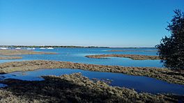
Piedras River, Spain facts for kids
Quick facts for kids Piedras River |
|
|---|---|
 |
|
| Location | Almendro Mountain |
| Group | Tinto, Odiel and Piedras |
| Coordinates | 37°14′45″N 7°09′52″W / 37.245853°N 7.164331°W |
| Part of | Almendro Mountain |
| Basin countries | Spain |
| Max. length | 40 km |
| Surface area | 549.5 km² |
The Piedras River is a coastal river in southwestern Spain. Its entire journey happens within the province of Huelva. It starts in the area of El Almendro. However, most of the smaller streams that feed it, coming from the Sierra del Almendro mountains, actually begin in Villanueva de los Castillejos. The river flows from north to south and empties into the ocean between the Flecha de Nueva Umbría (near Lepe) and Nuevo Portil (near Cartaya).
Contents
What's in a Name? The Piedras River's Story
The Piedras River gets its name from the many pebbles (piedras means stones or pebbles in Spanish) it leaves behind. When the river floods, it carries and deposits these stones along its banks and riverbed. Even though the river doesn't have a lot of water most of the time, its bed is quite stony, which explains its name.
The River's Home: Understanding the Piedras Basin
A river's basin is the area of land where all the rain and melting snow drain into that river and its tributaries. Even though the Piedras River isn't very long, its basin is quite large. It has a shape that looks a bit like the veins on a leaf, especially in its upper part. Here, nearly 20 streams from the Almendro mountain range come together. These streams form two or three main branches that then join up at the Piedras Reservoir. This is why the river's basin is so much bigger than you might expect for its length.
Who Looks After the River?
The water in the Piedras River basin is managed by a group called the Hydrographic Demarcation of the Tinto, Odiel and Piedras (DHTOP). This group is part of the Regional Government of Andalusia. They are responsible for making sure the river's water resources are used wisely.
River Structures: Reservoirs, Bridges, and Mills
Water Storage: Reservoirs Along the Piedras
The Piedras River has several important reservoirs along its path. These are like large lakes created by dams to store water.
- The Tres Picos Reservoir is very close to where the river starts. Its main job is to control how much water flows down the river.
- The Piedras Reservoir is the biggest one. Its water channel connects to the supply system for the industrial area of Huelva. It also feeds several acequias, which are canals used for irrigation.
- The Los Machos Reservoir also provides water for several acequias or canals.
Crossing the River: Bridges of the Piedras
Several bridges cross the Piedras River, all of them located after the Los Machos Reservoir.
- The Bridge of the A-49 highway crosses the river just a short distance downstream from the Los Machos Reservoir.
- The Tavirona Bridge was once a railway bridge for the Gibraleón-Ayamonte railroad line. Today, it's part of a walking and cycling path called the Vía Verde del Litoral.
- The La Barca Bridge carries the N-431 road over the river, connecting the towns of Lepe and Cartaya.
Old Technology: Tidal Mills
Historically, several tidal mills were built along the Piedras River. These mills used the power of the tides, specifically the ebb and flow of the water, to grind grain. Records show they were likely used from the 15th century all the way to the 19th century.
Here are some of the tidal mills found along the river, listed from its source to its mouth:
- Barca Mill (near Lepe)
- Legrete Mill (near Cartaya)
- Valletaray Mill (near Lepe)
- Higuera Mill (near Lepe)
Where the River Meets the Ocean: The Mouth of the Piedras
After flowing between Lepe and Cartaya, the Piedras River meets the Atlantic Ocean. However, its mouth runs parallel to the coast for a long stretch. This is because of a natural sand formation called the Flecha del Rompido. This "sand tongue" or spit is about 12 kilometers long. It keeps growing towards the east because of the constant ocean currents and waves coming from the west.
This unique river mouth forms a channel that gets a few dozen meters longer each year. Small boats can navigate this channel when the tide is high, as it's not very deep. In 1989, the mouth of the Piedras River was declared a Nature reserve called Marismas del río Piedras y Flecha del Rompido because of its special environment.
Plants and Animals of the River Mouth
The area around the river's mouth is home to many different plants and animals.
- Plants: You can find plants like sea hollies, retamas, and marran grass in the sandy bar area. In the marshy areas, there's almajo or small cordgrass. Near Cabezo of El Terrón, you'll see stone pine trees (Pinus pinea).
- Animals: This area is a great place for birds, including some endangered species like the red-crested pochard and the osprey. You might also spot little egrets and sandwich terns. Besides birds, there are chameleons and even Iberian lynx, along with other small mammals.
See also
 In Spanish: Río Piedras (España) para niños
 | Percy Lavon Julian |
 | Katherine Johnson |
 | George Washington Carver |
 | Annie Easley |

