
Cartaya facts for kids
Quick facts for kids
Cartaya
|
|||
|---|---|---|---|
|
Municipality & Town
|
|||
 |
|||
|
|||
| Motto(s): | |||

Cartaya
Location in Spain
|
|||
| Country | |||
| Autonomous Community | |||
| Province | |||
| Comarca | Costa Occidental de Huelva | ||
| Judicial district | Ayamonte | ||
| Municipality | |||
| Mancomunidad | Manc. Beturia | ||
| Foundation | 15th century | ||
| Boroughs |
|
||
| Government | |||
| • Type | Mayor–council | ||
| • Body | City Council of Cartaya | ||
| Area | |||
| • Total | 226,4 km2 (874 sq mi) | ||
| Elevation | 26 m (85 ft) | ||
| Population
(2018)
|
|||
| • Total | 19,433 | ||
| • Density | 8.5835/km2 (22.231/sq mi) | ||
| Demonym(s) | cartayero (m), cartayera (f) | ||
| Time zone | UTC+1 (CET) | ||
| • Summer (DST) | UTC+2 (CEST) | ||
| Postcode |
21450
|
||
| Website | http://www.ayto-cartaya.es/ | ||


Cartaya is a town and municipality in Spain, located in the Province of Huelva, in the region of Andalusia. In 2010, about 18,415 people lived there. It covers an area of 226.4 square kilometers.
The town of Cartaya was founded in the 15th century by Don Pedro de Zúñiga. Its name comes from an old word meaning "city". This suggests that people lived here much earlier. Evidence of ancient farms has been found.
The main way people make a living in Cartaya is through farming and fishing. However, in recent years, tourism has become very important. Many new places for visitors have been built. This has helped the town grow a lot.
Some cool places to visit in Cartaya include old buildings like the Convent of the Blessed Trinity and the Parish Church. There's also the Castle of the Zuñiga family. Cartaya also has 4 kilometers of beautiful beaches, like El Rompido and Nuevo Portil.
Contents
What Does the Name Cartaya Mean?
The name Cartaya likely comes from an ancient Phoenician word, Qart or Carteia. This word means "The City". During the time of Al-Andalus, the area was called qarqaya, which sounds very similar to the name today.
Symbols of Cartaya
Every town has symbols that represent it, like a shield and a flag.
What is on Cartaya's Shield?
The official shield of Cartaya shows a golden castle on a green mountain. Below the mountain are silver and blue waves. On each side of the castle, there are two people holding maces (a type of weapon).
This shield was officially approved in 1972.
What Does Cartaya's Flag Look Like?
The flag of Cartaya was chosen in 1998. It is red with six bands at the bottom. These bands are white and blue. In the center of the flag, you can see the town's shield.
Where is Cartaya Located?
Cartaya is about 26 kilometers west of Huelva and 112 kilometers from Seville.
How is Cartaya Situated?

The municipality of Cartaya is in the southwest part of the Province of Huelva. It is located on the Piedra River estuary. This river forms the southern and eastern borders of the area. The main town of Cartaya is on the east bank of the Piedra River.
The area covers 226.4 square kilometers. Its average height above sea level is 26 meters.
What Towns Border Cartaya?
The closest town to Cartaya is Lepe, which is about five miles to the west. To the northeast is Gibraleón. To the southeast is Punta Umbría, which used to be part of Cartaya until 1963.
| Northwest: Sanlúcar de Guadiana and Villanueva de los Castillejos | North: Villanueva de los Castillejos | Northeast: Gibraleón |
| West: Lepe |  |
East: Gibraleón, Aljaraque and Huelva |
| Southwest Lepe | South: Atlantic Ocean | Southeast: Punta Umbría |
What is the Landscape Like?
The land in Cartaya has three main types of areas. There's the river and coast zone, which includes the beaches. Then there's a wooded area with pine trees and small hills. The rest of the region is made up of open fields.
A special part of the landscape is a long strip of land called the "Arrow of Nueva Umbría" or "Arrow of El Rompido". This narrow piece of land is a source of disagreement between Cartaya and Lepe. Another important natural spot is the Lagoon of El Portil.
What is Cartaya's Climate Like?
Cartaya has a Mediterranean climate. This means the winters are very mild, rarely getting colder than 10°C. Summers are warm, often reaching over 30°C in July and August. It doesn't rain very much here.
The table below shows the average temperature and rainfall for 2007:
| Climate data for Cartaya | |||||||||||||
|---|---|---|---|---|---|---|---|---|---|---|---|---|---|
| Month | Jan | Feb | Mar | Apr | May | Jun | Jul | Aug | Sep | Oct | Nov | Dec | Year |
| Mean daily maximum °C (°F) | 16.3 (61.3) |
17.3 (63.1) |
19.7 (67.5) |
21 (70) |
24.8 (76.6) |
27.5 (81.5) |
32.7 (90.9) |
31 (88) |
28.1 (82.6) |
25 (77) |
21 (70) |
17.1 (62.8) |
23.5 (74.3) |
| Mean daily minimum °C (°F) | 6 (43) |
8.5 (47.3) |
6.9 (44.4) |
9.7 (49.5) |
12 (54) |
15.5 (59.9) |
21 (70) |
22.7 (72.9) |
20 (68) |
15.9 (60.6) |
11.7 (53.1) |
10.2 (50.4) |
13.5 (56.3) |
| Average precipitation mm (inches) | 42 (1.7) |
64 (2.5) |
16 (0.6) |
33 (1.3) |
36 (1.4) |
4 (0.2) |
2 (0.1) |
4 (0.2) |
55 (2.2) |
48 (1.9) |
52 (2.0) |
21 (0.8) |
373 (14.7) |
| Source: World Meteorological Organization (UN) | |||||||||||||
What Rivers and Water Sources are There?
The main river is the Piedra River. It forms the border between Cartaya and Lepe. The river starts in El Almendro.
Long ago, the river met the sea near El Rompido. Over time, sand and dirt from the river built up. This created new land features like the "Arrow of Nueva Umbria" and the Lagoon of El Portil. Cartaya gets its drinking water from the Chanza Reservoir.
What Kind of Plants and Animals Live Here?
Flora (Plants)
About 12,000 hectares of the area are covered by forests. These forests mostly have pine trees and juniper bushes. There are also new eucalyptus tree plantations. Some smaller areas have evergreen oaks and cork oaks.
The "Arrow of Nueva Umbria" is a special place. It's formed by winds and tides moving river sediments. Not many plants can grow there because of the conditions. Some typical plants include sea holly, beach grass, and other plants that can handle salty conditions.
-
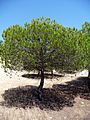
Pine in Aguas del Pino, San Miguel beach.
-
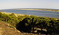
Arrow of Nueva Umbria.
-
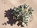
Sea holly.


A Look Back: Cartaya's History
Early Times: Prehistory and Romans
Not much evidence of very early human life has been found in Cartaya. However, tools from the Stone Age have been discovered near the Piedra River.
The area grew a lot when the Romans were in charge. Cartaya was near a Roman road. People here made a lot of pottery, especially large jars called amphorae. These were likely used to transport goods. Later, the Visigoths arrived, but there isn't much evidence of them in Cartaya.
The Middle Ages

During the time of Al-Andalus (when parts of Spain were ruled by Muslims), these lands were known as Cashtm. Later, in 1262, King Alfonso X the Wise took control of the region for the Christians. The Piedra River became the border between Cartaya and Lepe.
How Cartaya Was Founded

In the 15th century, the Zuñiga family ruled Cartaya. Don Pedro de Zúñiga y Manrique de Lara decided to build a town here. He wanted to protect a river crossing from attacks by pirates. Seven years later, he built a castle and a church. The impressive castle still stands today.
Cartaya's port, La Ribera, became important. By 1509, ships from Cartaya were fishing far away to supply fish for Seville. Trading ships traveled to places like Flanders. They traded wine and grain. Even though local shipyards built ships, this industry never became super important.
However, sailors from Cartaya were part of Christopher Columbus's famous voyages. Records show local names like Talafar, Vizcaino, and Alonso Rodríguez on board Columbus's first trip in 1492. They also seem to have returned on his second trip.
Modern Times


In the early modern era, a religious group built a convent in Cartaya. However, the number of people living in Cartaya seemed to go down. Some villages even disappeared, possibly because of a disease in 1602.
Later, especially in the 1700s, the population started to grow again. Cartaya became much bigger. This happened even after a big earthquake in Lisbon in 1755, which must have damaged many buildings.
In the late 1800s, the village of El Rompido started to grow. It became a fishing village because of a special way of catching tuna called almadraba. Many fishermen came from Portugal and married local women. That's why Portuguese last names are still common in El Rompido.
In the mid-1900s, the village of Punta Umbría wanted to become its own town. Even though Cartaya's town council didn't agree, Punta Umbría became a separate town in 1963. Since then, Cartaya has grown into one of the most populated towns in the province of Huelva.
People and How the Town is Arranged
Main Areas Where People Live
The three main places where people live in Cartaya are: Cartaya itself, El Rompido, and Nuevo Portil.
| Population cores | Inhabitants | Coordenades | Distance (km) |
|---|---|---|---|
| Cartaya | 18,415 | 37°16′59″N 7°09′17″W / 37.28306°N 7.15472°W | 0 |
| El Rompido | 1,629 | 37°13′04″N 7°07′20″W / 37.21778°N 7.12222°W | 8 |
| Nuevo Portil | 1,139 | 37°12′52″N 7°03′17″W / 37.21444°N 7.05472°W | 11 |
How Has the Population Changed?
In 2010, Cartaya had 18,415 people. The number of people has grown a lot, doubling since the late 1980s. However, the population dropped in 1963 when Punta Umbría became a separate town.
| Statistical exploitation of the Register. Historical series. Cartaya |
|---|
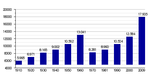 |
| Graph elaborated by: Wikipedia based on data from INE-2009 |
What Does the Population Pyramid Show?
A population pyramid helps us understand the age groups in a town. In Cartaya:
- People under 20 years old make up 23% of the population.
- Those between 20 and 40 years old are 37%.
- People between 40 and 60 years old are 26%.
- People over 60 years old make up 14%.
This shows that Cartaya's population is getting older, and fewer babies are being born.
Are There Many Immigrants?
In 2009, there were 3,197 foreign residents in Cartaya. This is about 17% of the total population, which is higher than the average for Spain. Most immigrants are from Morocco, Romania, and Ecuador.
How Does Cartaya Make Money?
Businesses and Jobs
In 2008, there were 1,105 companies in Cartaya. Most of these were small businesses with 5 or fewer workers. Only a few companies had more than 20 employees.
Cartaya is also part of a group of towns called the Beturia Mancomunidad. This group works together to help the economy grow. They even created a business school to improve the local economy.
See also
 In Spanish: Cartaya para niños
