
Pine Village, Indiana facts for kids
Quick facts for kids
Pine Village, Indiana
|
|
|---|---|

Lafayette Street at the intersection of 26 and 55
|
|

Pine Village, Indiana
Location in Warren County, Indiana

Pine Village, Indiana
Location in Indiana

Pine Village, Indiana
Location in the United States
|
|
| Country | United States |
| State | Indiana |
| County | Warren |
| Township | Adams |
| Founded | 1851 |
| Founded by | Isaac and John Metsker |
| Named for | Big Pine Creek |
| Area | |
| • Total | 0.12 sq mi (0.31 km2) |
| • Land | 0.12 sq mi (0.31 km2) |
| • Water | 0.00 sq mi (0.00 km2) |
| Elevation | 689 ft (210 m) |
| Population
(2020)
|
|
| • Total | 212 |
| • Density | 1,766.67/sq mi (680.07/km2) |
| Time zone | UTC-5 (Eastern (EST)) |
| • Summer (DST) | UTC-4 (EDT) |
| ZIP code |
47975
|
| Area code(s) | 765 |
| FIPS code | 18-60084 |
| GNIS feature ID | 2396857 |
Pine Village is a small town in Warren County, Indiana, in the United States. It is located in Adams Township. In 2020, about 212 people lived there.
Contents
History of Pine Village
Pine Village started as a trading post. It might have been named after a single pine tree on a nearby bluff or after Big Pine Creek itself. The town was officially planned in 1851 by Isaac and John R. Metsker. A church was already there, built a few years earlier.
The post office in Pine Village has been open since 1854.
Railroad Service in Pine Village
Trains started coming to Pine Village in the 1870s. By 1883, a railway line was finished that ran north and south. This line was used to transport a lot of coal, so people called it the "Coal Road."
Later, the railway company had problems. In 1922, Charles F. Propst bought the line and named it the Chicago, Attica and Southern Railroad. However, this company also ran into trouble. The train tracks through Pine Village were removed in the fall of 1945. They were pulled up using a Belgian horse and a special tool called a block and tackle.
Pine Village Football Team
In the mid-1910s, Pine Village had a very good professional football team. They were quite famous in the area!
-
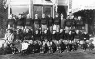
The football team of 1915

Geography of Pine Village

Pine Village is located where two main roads, State Road 55 and State Road 26, cross. It is also close to Big Pine Creek. The town is about 20 miles west of Lafayette and about 14 miles east of the Illinois border.
According to the 2010 census, Pine Village covers a total area of about 0.12 square miles (0.31 square kilometers), and all of it is land.
There's a small area on the east side of Pine Village, near the old railroad, that was known as Oklahoma. It has a grain elevator and some homes.
Population of Pine Village
| Historical population | |||
|---|---|---|---|
| Census | Pop. | %± | |
| 1900 | 279 | — | |
| 1910 | 352 | 26.2% | |
| 1920 | 301 | −14.5% | |
| 1930 | 323 | 7.3% | |
| 1940 | 303 | −6.2% | |
| 1950 | 311 | 2.6% | |
| 1960 | 309 | −0.6% | |
| 1970 | 291 | −5.8% | |
| 1980 | 257 | −11.7% | |
| 1990 | 134 | −47.9% | |
| 2000 | 255 | 90.3% | |
| 2010 | 217 | −14.9% | |
| 2020 | 212 | −2.3% | |
| U.S. Decennial Census | |||
In 2010, there were 143 people living in Pine Village, making up 60 households and 41 families. The town had about 1,027 people per square mile. Most people living in Pine Village (98.6%) were white. A small number (0.7%) were Black or African American. About 0.7% of the population was of Hispanic or Latino background.
The average age of people in Pine Village was about 46 years old. About 26.7% of households had children under 18 living with them. Most households (55%) were married couples.
The average income for a household in Pine Village was $48,750 per year. For families, the average income was $62,083. About 17.2% of the people in Pine Village lived below the poverty line.
See also
 In Spanish: Pine Village (Indiana) para niños
