Pinos, Zacatecas facts for kids
Quick facts for kids
Pinos
|
|
|---|---|
|
Town
|
|

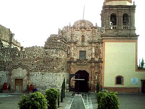
Iglesia Principal of the town of Pinos.
|
|
| Etymology: from the abundance of pine trees in the area | |
| Country | |
| state | Zacatecas |
| Municipality | Pinos |
| Largest city | Pinos |
| foundation | 12 February 1594 |
| Area | |
| • Total | 3,152 km2 (1,217 sq mi) |
| Population
(2010)
|
|
| • Total | 5,611 |
| • Density | 1.7801/km2 (4.6105/sq mi) |
| Time zone | UTC−06:00 (Central Standard Time) |
| • Summer (DST) | UTC−05:00 (Central Daylight Time) |
| ISO 3166 code | MEX |
| UNESCO World Heritage Site | |
| Official name | Town of Pinos |
| Part of | Camino Real de Tierra Adentro |
| Criteria | Cultural: (ii)(iv) |
| Inscription | 2010 (34th Session) |
| Area | 3.35 ha (8.3 acres) |
| Buffer zone | 14.18 ha (35.0 acres) |
The town of Pinos is a historic place in Mexico. It is found in the southeastern part of the state of Zacatecas. The town is part of the larger Pinos municipality. Its name, Pinos, comes from the many pine trees that used to grow in the area.
Contents
Discovering Pinos: A Historic Town
Pinos is a town with a long and interesting history. It was officially founded on February 12, 1594. This makes it one of the oldest towns in the region. Over the centuries, Pinos has kept much of its original charm.
Location and Landscape
Pinos is located in a beautiful area of Zacatecas. The region is known for its natural beauty. The town sits in a landscape that once had many pine trees. This gave the town its unique name.
Population and People
According to the 2010 census, about 5,611 people live in Pinos. The people of Pinos are known for their strong community spirit. They work to preserve their town's heritage.
Local Government
The town of Pinos is led by a municipal president. This person is like a mayor for the whole municipality. As of the information given, Alfonso Contreras Hernández is the municipal president. They help manage the town and its services.
Pinos: A UNESCO World Heritage Site
Pinos is very special because it is a UNESCO World Heritage Site. This means it has global importance. It is recognized for its cultural and historical value.
Part of the Royal Road
Pinos is a key stop on the Camino Real de Tierra Adentro. This translates to the "Royal Road of the Interior." It was a very important trade route in colonial times. The road stretched for over 2,500 kilometers (about 1,550 miles). It connected Mexico City to Santa Fe, New Mexico.
Why It's Important
The Camino Real de Tierra Adentro was used to transport silver. It also helped spread culture and ideas. Pinos played a vital role as a resting point. It provided supplies for travelers and traders. The town's architecture shows its historical importance.
Recognized by UNESCO
UNESCO added Pinos to its World Heritage list in 2010. This recognition highlights its unique history. It also shows its well-preserved colonial buildings. The town's layout and buildings reflect its past.
Life and Culture in Pinos
Life in Pinos often revolves around its rich traditions. The town has a quiet, peaceful atmosphere. Many of its buildings are from the colonial era.
Architecture and Buildings
The main church, called Iglesia Principal, is a beautiful example. It shows the architectural style of the past. Walking through Pinos feels like stepping back in time. The town has many old stone buildings.
Local Traditions
People in Pinos celebrate various local festivals. These events often include music, dance, and traditional foods. They are a great way to experience the local culture. The community takes pride in its customs.
Economy and Activities
Historically, mining was important in the region. Today, the economy might include farming and small businesses. Tourism also plays a role, especially with its UNESCO status. Visitors come to explore its history.
Images for kids
See also
 In Spanish: Pinos (Zacatecas) para niños


