Piriaka railway station facts for kids
Quick facts for kids
Piriaka railway station
|
|||||||||||
|---|---|---|---|---|---|---|---|---|---|---|---|

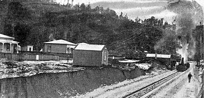
Piriaka in 1906
|
|||||||||||
| Location | New Zealand | ||||||||||
| Coordinates | 38°55′27″S 175°20′31″E / 38.924200°S 175.341900°E | ||||||||||
| Elevation | 230 m (750 ft) | ||||||||||
| Line(s) | North Island Main Trunk | ||||||||||
| Distance | Wellington 387.27 km (240.64 mi) | ||||||||||
| History | |||||||||||
| Opened | 11 October 1904 | ||||||||||
| Closed | 4 September 1972 | ||||||||||
| Electrified | June 1988 | ||||||||||
| Previous names | Pirihaka | ||||||||||
| Services | |||||||||||
|
|||||||||||
Piriaka was a railway station located in the Ruapehu District of New Zealand. It was an important stop on the North Island Main Trunk line, which is a main railway route across the North Island. The station served the small community of Piriaka.
Contents
Piriaka Station: A Look Back
Piriaka station was about 5.27 kilometers (3.27 miles) north of Kakahi and 4.63 kilometers (2.88 miles) south of Manunui. It was first known as Pirihaka. The name was changed to Piriaka on April 25, 1902.
Building the Station
Work on the station was already well underway by 1903. The railway tracks were laid south of Piriaka by May 1904. Goods trains started using the station on October 11, 1904. The station officially opened for all traffic on November 9, 1908.
By late 1908, Piriaka station had several important features. It had a "6th class station" building, which was a standard design for smaller stations. There was also a water supply, toilets, and a long platform for passengers. This platform was about 91 meters (300 feet) long and 6 meters (20 feet) wide.
Station Facilities
The station also had a special track called a passing loop. This allowed trains to wait while another train passed by. The loop was long enough for 48 wagons. For goods, there was a loading bank where items could be moved on and off trains. There were also yards for cattle and a goods shed to store items. The goods shed was about 9 meters (30 feet) long and 6 meters (20 feet) wide.
Changes Over Time
Originally, there was a level crossing where the railway met what is now State Highway 4. In 1937, this crossing was replaced with a strong concrete bridge. This made the area safer for both trains and road traffic.
Supporting Local Business
The railway played a big part in local industries. For example, it helped the Kaitieke butter factory, which opened in Piriaka in 1913. The factory relied on the railway to deliver cream. In 1923, this factory produced over 400 tons of butter! Even by 1937, when roads had improved, the railway still transported some supplies for the factory.
The Station's Closing
Piriaka railway station served the community for many years. However, like many smaller stations, it eventually closed. The station stopped operating on September 4, 1972. Even though the station is no longer open, the North Island Main Trunk line still runs through Piriaka today.
 | Aaron Henry |
 | T. R. M. Howard |
 | Jesse Jackson |


