Buck Creek Township, Hancock County, Indiana facts for kids
Quick facts for kids
Buck Creek Township
|
|
|---|---|

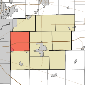
Location in Hancock County
|
|
| Country | United States |
| State | Indiana |
| County | Hancock |
| Government | |
| • Type | Indiana township |
| Area | |
| • Total | 36.02 sq mi (93.3 km2) |
| • Land | 35.93 sq mi (93.1 km2) |
| • Water | 0.09 sq mi (0.2 km2) 0.25% |
| Elevation | 846 ft (258 m) |
| Population
(2020)
|
|
| • Total | 9,304 |
| • Density | 234.6/sq mi (90.6/km2) |
| GNIS feature ID | 0453145 |
Buck Creek Township is a community located in Hancock County, Indiana, in the United States. It's one of nine townships in this county. A "township" is like a small local government area. In 2010, about 8,430 people lived here, and there were 3,158 homes. By 2020, the population grew to 9,304!
Contents
History of Buck Creek Township
Buck Creek Township was officially started in 1831. It got its name from Buck Creek, which is the biggest waterway flowing through the area.
An interesting piece of history is that a specific airplane, the Lockheed PV-2 Harpoon No. 37396, was added to the National Register of Historic Places in 2009. This register lists places, buildings, or objects that are important to American history.
Geography and Location
Buck Creek Township covers an area of about 36 square miles. Most of this area, about 35.93 square miles, is land. A small part, about 0.09 square miles, is water.
Waterways in the Township
Several small streams flow through Buck Creek Township. These include Amity Branch, Lead Creek, and Snider Branch.
Cities and Towns Nearby
- Cumberland (the northeast part of this city is in the township)
Unincorporated Communities
These are smaller communities that don't have their own local government like a city or town:
- Mohawk
- Mount Comfort
- Pleasant Acres
Neighboring Townships
Buck Creek Township shares its borders with several other townships:
- Vernon Township (to the north)
- Center Township (to the east)
- Sugar Creek Township (to the south)
- Warren Township, Marion County (to the southwest)
- Lawrence Township, Marion County (to the northwest)
Local Cemeteries
There are nine cemeteries located within the township:
- Arnett
- Burris
- Fish
- Griffith
- Mount Pleasant
- Pet
- Scotten
- Snider
- Steele
Major Roads and Transportation
 Interstate 70 is a major highway that runs through the township.
- The Indianapolis Regional Airport is also located here, providing air travel services.
See also
 In Spanish: Municipio de Buck Creek para niños

