Cumberland, Indiana facts for kids
Quick facts for kids
Cumberland, Indiana
|
|
|---|---|

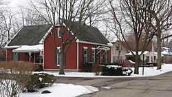
A residential neighborhood in northern Cumberland
|
|

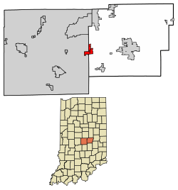
Location in Hancock County and Marion County, Indiana
|
|
| Country | United States |
| State | Indiana |
| Counties | Hancock, Marion |
| Area | |
| • Total | 2.82 sq mi (7.30 km2) |
| • Land | 2.81 sq mi (7.28 km2) |
| • Water | 0.01 sq mi (0.02 km2) |
| Elevation | 833 ft (254 m) |
| Population
(2020)
|
|
| • Total | 5,954 |
| • Density | 2,118.11/sq mi (817.93/km2) |
| Time zone | UTC-5 (EST) |
| • Summer (DST) | UTC-4 (EST) |
| ZIP code |
46229
|
| Area code(s) | 317 |
| FIPS code | 18-16336 |
| GNIS feature ID | 2396672 |
Cumberland is a town in Indiana, United States. It is located in both Hancock and Marion counties. In 2023, the population was estimated to be around 6,419 people. This was an increase from 5,169 people in 2010.
Contents
History of Cumberland
Cumberland was founded in the 1830s. This happened when the important National Road, also known as the Cumberland Road, was extended to this area. A post office served the town from 1834 until 1958.
Since 1970, the part of Cumberland in Marion County has been part of a special government system. This system is called Unigov. It helps the town work closely with the government of Indianapolis.
Geography of Cumberland
The main part of Cumberland is in eastern Marion County. However, the town's borders stretch east and north into western Hancock County. This means most of the town's land is now in Hancock County.
U.S. Route 40 is the main road through Cumberland. It follows the path of the historic National Road. This road leads about 10 miles west to downtown Indianapolis. It also goes about 10 miles east to Greenfield, which is the county seat of Hancock County.
The town covers about 2.82 square miles (7.30 square kilometers). Only a very small part of this area is water. Buck Creek flows through Cumberland. It then goes south to join Sugar Creek. The town is part of the area that drains into the East Branch of the White River.
People of Cumberland
| Historical population | |||
|---|---|---|---|
| Census | Pop. | %± | |
| 1880 | 299 | — | |
| 1960 | 872 | — | |
| 1970 | 1,478 | 69.5% | |
| 1980 | 3,375 | 128.3% | |
| 1990 | 4,557 | 35.0% | |
| 2000 | 5,500 | 20.7% | |
| 2010 | 5,169 | −6.0% | |
| 2020 | 5,954 | 15.2% | |
| U.S. Decennial Census | |||
Population in 2010
In 2010, there were 5,169 people living in Cumberland. These people lived in 1,972 households. About 1,422 of these households were families.
The town had about 2,509 people per square mile. There were 2,233 housing units in total. Most residents were White (77.0%) or African American (16.8%). About 5.3% of the population was Hispanic or Latino.
Many households (36.4%) had children under 18 living with them. About half (50.3%) were married couples. The average household had 2.61 people. The average family had 3.05 people.
The average age in Cumberland was 38.4 years. About 27.4% of residents were under 18. About 11.5% were 65 years old or older. The town had slightly more females (51.9%) than males (48.1%).
See also
 In Spanish: Cumberland (Indiana) para niños
 | William Lucy |
 | Charles Hayes |
 | Cleveland Robinson |

