
Pleiku facts for kids
Quick facts for kids
Pleiku
Thành phố Pleiku
Pờ-lây-cu/Plây-cu
|
||
|---|---|---|
| Pleiku City | ||
|
From top to bottom, from left to right: Pleiku at night, Minh Thành pagoda, Đại đoàn kết square, Đức An lake, Biển Hồ
|
||
|
||

Pleiku
Location in Vietnam
|
||
| Country | ||
| Province | Gia Lai | |
| Area | ||
| • Total | 260.77 km2 (100.68 sq mi) | |
| Elevation | 740 m (2,420 ft) | |
| Population
(2023 census)
|
||
| • Total | 274.018 | |
| • Density | 1.050/km2 (2.72/sq mi) | |
| Climate | Aw | |


.jpg)


Pleiku is a city in central Vietnam. It is located in the Central Highlands region. Pleiku is also the capital city of the Gia Lai Province.
Many years ago, the city was mostly home to the Bahnar and Jarai ethnic groups. These groups are sometimes called Montagnards. Today, most people living in Pleiku are from the Kinh ethnic group. The city covers an area of about 260.77 square kilometers (100 square miles).
As of 2023, about 274,018 people live in Pleiku.
Contents
What's in a Name? The Meaning of Pleiku
The name "Pleiku" was first officially used in 1905. This was when the province of Gia Lai was created by the Governor-General of French Indochina. The first written record called it "Plei-Kou-Derr".
The word "Plơi" means "village" in the Jarai language. The word "Kơdưr" can mean "north" or "upper". So, "Pleiku" can be understood as "upper village" or "village in the north".
The word "Derr" was likely added by the French. It helped to tell this village apart from others in the area. The name "Pleiku" has been used ever since the colonial period. It is still the city's official name today.
A Look at Pleiku's Past
Pleiku During the First Indochina War
Towards the end of the First Indochina War in June 1954, a French army group was told to move to Pleiku. They also had to reopen a main road between Pleiku and Buôn Ma Thuột. This led to the final big fight of the war, known as the Battle of Mang Yang Pass.
Pleiku During the Vietnam War
Pleiku was a very important place during the Vietnam War. It was a key stop for military supplies coming from the coast. Supplies traveled along Highway 19 from Qui Nhơn to Pleiku.
The city was also centrally located on the plateau. It was between Kon Tum to the north and Buôn Ma Thuột to the south. This made Pleiku a main defense center for the entire highland region of South Vietnam. Both sides knew how important it was. The United States set up a military base there early in the war. A major attack by the Việt Cộng on this base in 1965 helped bring more U.S. troops into the conflict.
Later in the war, in 1975, the city of Buôn Ma Thuột fell to North Vietnamese forces. This made the supply route to Pleiku unsafe. Because of this, the president at the time, Nguyễn Văn Thiệu, ordered a quick evacuation of Pleiku. The plan was for soldiers and people to leave Pleiku and Kon Tum. They tried to use a less-used road to get to Tuy Hòa. This evacuation was very difficult and caused many problems for the people trying to leave.
Where is Pleiku?
Pleiku is in the middle of Gia Lai province. It shares borders with several districts:
- Dak Doa district to the east
- Ia Grai district to the west
- Chu Prong district to the south
- Chu Pah district to the north
Pleiku is located where National Highway 14 and National Route 19 meet. These roads are part of the Ho Chi Minh Highway. This location is also close to the borders of Cambodia and Laos.
The city is the main center for business, government, culture, and social life in Gia Lai province. Pleiku is about 465 km (289 miles) north of Ho Chi Minh City. It is also 1,287 km (800 miles) south of Hanoi. The city sits at an average height of 700m to 800m (2,297 to 2,625 feet) above sea level.
Pleiku's Weather
| Climate data for Pleiku | |||||||||||||
|---|---|---|---|---|---|---|---|---|---|---|---|---|---|
| Month | Jan | Feb | Mar | Apr | May | Jun | Jul | Aug | Sep | Oct | Nov | Dec | Year |
| Record high °C (°F) | 33.2 (91.8) |
35.0 (95.0) |
36.3 (97.3) |
36.3 (97.3) |
35.1 (95.2) |
33.1 (91.6) |
32.5 (90.5) |
32.0 (89.6) |
32.5 (90.5) |
32.8 (91.0) |
32.0 (89.6) |
34.0 (93.2) |
36.3 (97.3) |
| Mean daily maximum °C (°F) | 26.4 (79.5) |
28.5 (83.3) |
30.5 (86.9) |
31.1 (88.0) |
29.5 (85.1) |
27.4 (81.3) |
26.7 (80.1) |
26.4 (79.5) |
26.9 (80.4) |
27.1 (80.8) |
26.4 (79.5) |
25.8 (78.4) |
27.7 (81.9) |
| Daily mean °C (°F) | 19.0 (66.2) |
20.6 (69.1) |
22.7 (72.9) |
24.2 (75.6) |
23.9 (75.0) |
23.1 (73.6) |
22.5 (72.5) |
22.3 (72.1) |
22.3 (72.1) |
21.9 (71.4) |
20.8 (69.4) |
19.4 (66.9) |
21.9 (71.4) |
| Mean daily minimum °C (°F) | 14.0 (57.2) |
15.1 (59.2) |
17.4 (63.3) |
19.4 (66.9) |
20.5 (68.9) |
20.5 (68.9) |
20.1 (68.2) |
20.1 (68.2) |
19.8 (67.6) |
18.6 (65.5) |
17.1 (62.8) |
15.2 (59.4) |
18.1 (64.6) |
| Record low °C (°F) | 5.6 (42.1) |
6.8 (44.2) |
5.9 (42.6) |
10.0 (50.0) |
12.6 (54.7) |
11.0 (51.8) |
15.6 (60.1) |
14.8 (58.6) |
13.7 (56.7) |
11.0 (51.8) |
5.8 (42.4) |
5.8 (42.4) |
5.6 (42.1) |
| Average rainfall mm (inches) | 2.4 (0.09) |
6.7 (0.26) |
24.2 (0.95) |
92.8 (3.65) |
249.2 (9.81) |
322.9 (12.71) |
396.1 (15.59) |
462.7 (18.22) |
358.9 (14.13) |
190.8 (7.51) |
62.8 (2.47) |
10.8 (0.43) |
2,179.9 (85.82) |
| Average rainy days | 0.6 | 0.8 | 3.1 | 8.1 | 17.7 | 23.0 | 26.6 | 27.4 | 24.8 | 15.9 | 7.2 | 2.3 | 157.5 |
| Average relative humidity (%) | 76.6 | 73.7 | 72.0 | 75.1 | 82.9 | 89.1 | 90.8 | 91.9 | 90.4 | 86.1 | 82.1 | 79.0 | 82.5 |
| Mean monthly sunshine hours | 263.2 | 260.1 | 272.1 | 240.8 | 210.1 | 155.5 | 146.2 | 127.9 | 136.1 | 178.1 | 199.1 | 229.3 | 2,415.3 |
| Source 1: Vietnam Institute for Building Science and Technology | |||||||||||||
| Source 2: The Yearbook of Indochina (1930-1931 and 1937-1938) | |||||||||||||
Who Lives in Pleiku?
In 1971, Pleiku had about 34,867 residents. Today, the city is home to 28 different ethnic groups. Most people, about 87.5%, are from the Kinh group. The rest, about 12.5%, are mainly from the Gia Rai and Ba Na ethnic groups.
Many ethnic minority groups live in specific villages within the city. These include Plei Op village, Kep village, and Brúk Ngol village. The city has about 62,829 households. Around 274,048 people live there permanently. If you include people who have moved there, the total population is about 504,984.
City Layout: Administrative Divisions
Pleiku city is divided into 22 smaller areas. These include 14 wards and 8 communes.
- The 14 wards are: Chi Lang, Dien Hong, Dong Da, Hoa Lu, Hoi Phu, Hoi Thuong, Ia Kring, Phu Dong, Tay Son, Thang Loi, Thong Nhat, Tra Ba, Yen Do, and Yen The.
- The 8 communes are: An Phu, Bien Ho, Chu A, Dien Phu, Gao, Ia Kenh, Tan Son, and Tra Da.
Sports in Pleiku
The city is home to the Hoàng Anh Gia Lai football (soccer) club. They are a well-known team in Vietnam.
Getting Around: Transport in Pleiku
Pleiku is an important transport hub. It sits at the meeting point of several national roads.
- National Route 14 goes north to Kon Tum and south to Buôn Ma Thuột.
- National Route 19 goes west towards Stung Treng in Cambodia and east to Bình Định Province.
The city also has its own airport, Pleiku Airport. It is located just outside the city center.
Images for kids
-
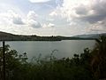
T' Nung Lake, a beautiful lake near Pleiku.
-
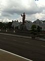
Pleiku Square, a large public space in the city.
-
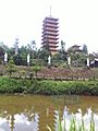
Minh Thanh Pagoda, a peaceful temple in Pleiku.


See also
 In Spanish: Pleiku para niños
