Chesterfield Township, Michigan facts for kids
Quick facts for kids
Chesterfield Township, Michigan
|
|||
|---|---|---|---|
|
Charter township
|
|||
| Chesterfield Charter Township | |||
|
|||

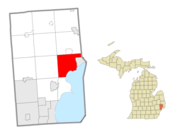
Location of Chesterfield Township in Macomb County, Michigan (left) and of Macomb County in Michigan (right)
|
|||
| Country | |||
| State | |||
| County | |||
| Organized | 1842 | ||
| Area | |||
| • Total | 30.6 sq mi (79 km2) | ||
| • Land | 27.6 sq mi (71 km2) | ||
| • Water | 3.0 sq mi (8 km2) | ||
| Elevation | 591 ft (180 m) | ||
| Population
(2020)
|
|||
| • Total | 45,376 | ||
| • Density | 1,644.3/sq mi (634.9/km2) | ||
| Time zone | UTC-5 (Eastern (EST)) | ||
| • Summer (DST) | UTC-4 (EDT) | ||
| ZIP Codes |
48047, 48051
|
||
| Area code(s) | 586 | ||
| FIPS code | 26-15340 | ||
| GNIS ID | 1626074 | ||
Chesterfield Charter Township is a special type of town in Macomb County, Michigan, USA. It's called a "charter township" because it has more local control, like a small city. In 2020, about 45,376 people lived here. It's part of the larger Metro Detroit area.
Contents
History of Chesterfield Township
Chesterfield Township was first officially set up in 1842. At that time, it was a "general law township." This means it followed the basic rules for townships set by the state.
In 1989, it became a "charter township." This change gave it more power to make its own local rules and provide services, similar to how a city operates.
The very first European-American settlement in this area was a small community called Chesterfield. It was settled around 1830. When the Grand Trunk Railway came through in 1865, it helped businesses grow in the area. Chesterfield even had its own post office for many years.
Geography and Nature
Chesterfield Township is located in the eastern part of Macomb County. It shares borders with several other towns and villages. To the north, you'll find Lenox Township and the village of New Haven. To the east, it borders Ira Township and the village of New Baltimore.
The southeastern side of the township touches Anchor Bay, which is a part of Lake St. Clair. To the south is Harrison Township, and to the west is Macomb Township.
The United States Census Bureau says that Chesterfield Township covers a total area of about 30.6 square miles (79.3 square kilometers). Most of this area, about 27.6 square miles (71.5 square kilometers), is land. The rest, about 3.0 square miles (7.8 square kilometers), is water.
Many parts of Chesterfield Township have modern neighborhoods and shopping areas. The people living here come from many different backgrounds. The southeastern part of the township is influenced by Anchor Bay. You can find many boats, docks, and businesses related to the water there.
Communities in the Township
Chesterfield Township has several smaller communities within it. These are not separate cities or villages, but distinct neighborhoods.
- Anchor Bay Gardens is located off Jefferson Avenue.
- Anchor Bay Harbor is also on Jefferson Avenue, south of Anchor Bay Gardens.
- Anchor Bay Shores is another community off Jefferson Avenue, south of Anchor Bay Harbor.
- Chesterfield is located along M-3, between 23 Mile Road and 22 Mile Road.
- Chesterfield Shores is close to the border with the City of New Baltimore.
- Fairchild was a community in the southern part of the township. It had a post office that started in 1906.
- Lottivue is found between Jefferson Avenue, Lake Saint Clair, Brandenburg Park, and Schneider Road.
- Milton is located at Gratiot Avenue and 24 Mile Road. It used to be a stop on the Grand Trunk Railroad. The very first post office in the township was set up here in 1837. Milton was once a busy place with a school, three churches, a doctor, and a blacksmith. A famous saloon, known as the "Teddy Bear Bar," was here until 2004. The old Milton School building was also torn down in 2002.
- Point Lakeview is southwest of Lottivue, between the Salt River and Lake Saint Clair.
- Sebille Manor is located northwest of Anchor Bay Harbor.
People and Population
According to the 2020 census, Chesterfield Township had a population of 45,376 people. In 2010, the population was 43,381.
Most people in the township are white. However, the community is becoming more diverse, with growing numbers of African American and Asian residents. About 2.4% of the population in 2010 identified as Hispanic or Latino.
In 2000, about 29.8% of the population was under 18 years old. The average age of people living in the township was 33 years.
Fire Department
Chesterfield Township has its own fire department. It has both full-time and part-time firefighters. The department operates two fire stations 24 hours a day, every day.
Education
Students in Chesterfield Township mostly attend schools in two main districts:
- Anchor Bay School District
- L’Anse Creuse Public Schools
A small part of the northern township is also served by New Haven Community Schools.
See also
 In Spanish: Municipio de Chesterfield (Míchigan) para niños


