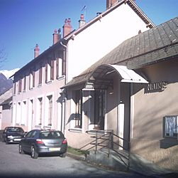
Poligny, Hautes-Alpes facts for kids
Quick facts for kids
Poligny
|
||
|---|---|---|

Town hall
|
||
|
||
| Country | France | |
| Region | Provence-Alpes-Côte d'Azur | |
| Department | Hautes-Alpes | |
| Arrondissement | Gap | |
| Canton | Saint-Bonnet-en-Champsaur | |
| Area
1
|
13.81 km2 (5.33 sq mi) | |
| Population
(Jan. 2021)
|
Lua error in Module:Wd at line 1,575: attempt to index field 'wikibase' (a nil value). | |
| Time zone | UTC+01:00 (CET) | |
| • Summer (DST) | UTC+02:00 (CEST) | |
| INSEE/Postal code |
05104 /05500
|
|
| Elevation | 896–2,082 m (2,940–6,831 ft) (avg. 1,062 m or 3,484 ft) |
|
| 1 French Land Register data, which excludes lakes, ponds, glaciers > 1 km2 (0.386 sq mi or 247 acres) and river estuaries. | ||
Poligny is a small town, also called a 'commune,' located in southeastern France. It's part of the Hautes-Alpes department and the Provence-Alpes-Côte d'Azur region. This area is known for its beautiful mountains, the Alps!
Contents
Exploring Poligny's Land
Poligny is in the Alps mountains, but not all of it is super hilly! The northern part of the town is quite flat. This is because it sits in a valley, which is like a low area between mountains. However, if you go to the southern part of Poligny, you'll find many more hills.
Getting Around Poligny
Roads and Travel
Several roads help people travel in and out of Poligny. Roads like the D17, D217A, and D817 go right through the village. There's also a bigger road, the N85, which goes around the main village but is still within the Poligny area.
How Many People Live Here?
Poligny is a small community. The number of people living there has changed over the years.
| Historical population | ||
|---|---|---|
| Year | Pop. | ±% |
| 1962 | 254 | — |
| 1968 | 262 | +3.1% |
| 1975 | 232 | −11.5% |
| 1982 | 219 | −5.6% |
| 1990 | 237 | +8.2% |
| 1999 | 230 | −3.0% |
| 2008 | 305 | +32.6% |
See also
 In Spanish: Poligny (Altos Alpes) para niños


