Port Wing (town), Wisconsin facts for kids
Quick facts for kids
Port Wing, Wisconsin
|
|
|---|---|

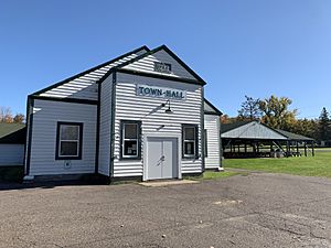
Port Wing Town Hall
|
|

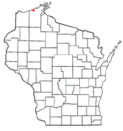
Location of Port Wing, Wisconsin
|
|
| Country | |
| State | |
| County | Bayfield |
| Area | |
| • Total | 46.8 sq mi (121.1 km2) |
| • Land | 46.7 sq mi (120.9 km2) |
| • Water | 0.08 sq mi (0.2 km2) |
| Elevation | 817 ft (249 m) |
| Population
(2020)
|
|
| • Total | 389 |
| • Density | 8.320/sq mi (3.212/km2) |
| Time zone | UTC-6 (Central (CST)) |
| • Summer (DST) | UTC-5 (CDT) |
| Area code(s) | 715 & 534 |
| FIPS code | 55-64512 |
| GNIS feature ID | 1583962 |
Port Wing is a small town in Bayfield County, Wisconsin, United States. In 2020, about 389 people lived there. This was a small increase from the 368 people counted in 2010. The community of Port Wing is also located within this town.
Getting Around Port Wing
The main roads in Port Wing are Wisconsin Highway 13 and Bayfield County Highway A. These roads help people travel in and out of the town.
Port Wing's Location and Size
Port Wing covers a total area of about 121.1 square kilometers (which is about 46.8 square miles). Most of this area, 120.9 square kilometers, is land. A very small part, about 0.2 square kilometers, is water.
Who Lives in Port Wing?
In 2000, there were 420 people living in Port Wing. Most of the people were White (about 97.6%). A smaller number were Native American (about 1.4%) or Asian (about 0.2%). Some people were from two or more races.
The people living in Port Wing are of different ages. About 21.4% of the population was under 18 years old. About 18.8% of the people were 65 years old or older. The average age in the town was 46 years.
See also

- In Spanish: Port Wing (Wisconsin) para niños
 | James Van Der Zee |
 | Alma Thomas |
 | Ellis Wilson |
 | Margaret Taylor-Burroughs |

