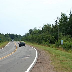
Prince Edward Island Route 2 facts for kids
Quick facts for kids
Route 2 |
||||
|---|---|---|---|---|
| All Weather Highway Veterans Memorial Highway |
||||
|
Route 2 highlighted in red.
|
||||
 |
||||
| Route information | ||||
| Maintained by Department of Transportation, Infrastructure, and Energy | ||||
| Length | 217.1 km (134.9 mi) | |||
| Existed | 1890–present | |||
| Major junctions | ||||
| West end | ||||
|
||||
| East end | ||||
| Location | ||||
| Counties: | Kings, Queens, Prince | |||
| Major cities: | Charlottetown, Summerside | |||
| Highway system | ||||
Provincial highways in Prince Edward Island
|
||||
Route 2, also known as Veterans Memorial Highway and the All Weather Highway, is a long road that stretches across Prince Edward Island, Canada. It is about 216 kilometers (134 miles) long and has two lanes. This important highway connects the town of Tignish in the west to Souris in the east.
Route 2 holds a special place in history! It was the very first numbered highway in Prince Edward Island. It first opened way back in 1890, connecting the cities of Charlottetown and Summerside.
This highway passes through major cities like Summerside and Charlottetown. It also generally follows the path of the old main railway line. That railway line was no longer used after 1989.
The highway was first paved in the 1950s. Many improvements have been made in recent years. In the 1990s, a new part of Route 2 was built around the northern and eastern sides of Charlottetown. This project was funded by money given to the province after the railway closed. This section is now part of Route 1 (the Trans-Canada Highway). However, Route 2 still uses a small part of this new road.
Contents
What are the Names of Route 2?
Route 2 has a few different names. Each name tells us something interesting about the highway.
The All Weather Highway
Route 2 is often called the "All Weather Highway." This name came about because it was one of the first roads in Prince Edward Island that stayed open for cars and trucks all year round. This was a big deal, especially during snowy winters!
Veterans Memorial Highway
In 2003, the highway was given another special name: "Veterans Memorial Highway." This name honors all the brave people who have served in the military. In the same year, the highway received money from the government for important upgrades. These upgrades helped the road handle more traffic.
Local Names for Sections of Route 2
Different parts of Route 2 have their own local names. These names often come from the towns or areas they pass through:
- Souris Road: This part runs from Souris to Dingwells Mills.
- St. Peter's Highway: This section goes from Dingwells Mills to Charlottetown.
- Malpeque Road: You'll find this part from Charlottetown to Hunter River.
- New Annan Road: This section connects Kensington to Summerside.
- Western Road: This name is used for the highway from Summerside all the way to Tignish.
How Was Route 2 Changed Near Mount Pleasant?
For several years in the 1940s, a part of Route 2 was moved. This happened in the small farming area of Mount Pleasant, which is west of Summerside. The road was moved because an air force base was built there. This base was called RCAF Station Mount Pleasant.
After World War II ended, the air force base closed down. The "Western Road" (which is part of Route 2) was then put back on its original path. This path now runs right along where the old air force base's runway and paved area used to be. The road that was built to go around the base is still used today as a local road.
 | Sharif Bey |
 | Hale Woodruff |
 | Richmond Barthé |
 | Purvis Young |


