
Progress, Pennsylvania facts for kids
Quick facts for kids
Progress, Pennsylvania
|
|
|---|---|

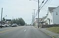
Westbound US 22 (Walnut Street) in Progress
|
|

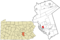
Location in Dauphin County and state of Pennsylvania
|
|
| Country | United States |
| State | Pennsylvania |
| County | Dauphin |
| Townships | Susquehanna, Lower Paxton |
| Area | |
| • Total | 3.02 sq mi (7.81 km2) |
| • Land | 3.02 sq mi (7.81 km2) |
| • Water | 0.00 sq mi (0.00 km2) |
| Elevation | 500 ft (200 m) |
| Population
(2020)
|
|
| • Total | 11,168 |
| • Density | 3,704.15/sq mi (1,430.24/km2) |
| Time zone | UTC-5 (Eastern (EST)) |
| • Summer (DST) | UTC-4 (EDT) |
| ZIP code |
17109
|
| Area code(s) | 717 and 223 |
| FIPS code | 42-62736 |
| GNIS feature ID | 1184434 |
Progress is a community located in Pennsylvania, United States. It is mostly found in Susquehanna Township but also stretches into Lower Paxton Township. Progress is known as a census-designated place (CDP). This means it's an area that looks like a town but isn't officially governed as one.
In 2020, about 11,168 people lived in Progress. It is part of the larger Harrisburg–Carlisle metropolitan area. This area includes several cities and towns that are connected by jobs and daily life.
Contents
The History of Progress
When Susquehanna Township was created in 1815, Progress was the only settled area in its southern part. A person named Daniel Shell first planned out this community in the 1700s.
Over time, Progress was known by different names. These included Jacob's Plains, Mud Town, and Shellstown. Eventually, it got its current name, Progress. Most people living in the township originally lived in this community.
Old-fashioned streetcars, called trolley cars, used to run along what is now U.S. Route 22. These trolleys were a main way to travel until 1936. That's when the road was made wider to handle more cars. The name "Progress" was chosen to reflect the forward-thinking spirit of the people who first lived there.
Where is Progress Located?
Progress is in the southeastern part of Susquehanna Township. It is located where Walnut Street and Shell Street meet. The community also extends east into the western section of Lower Paxton Township.
To the east of Progress, you will find Colonial Park. To the southwest, it shares a border with the small town of Penbrook.
The total area of Progress is about 7.3 square kilometers (about 2.8 square miles). All of this area is land. There are no large bodies of water within the community.
Main Roads in Progress
Two important roads run through Progress. U.S. Route 22, also known as Jonestown Road, runs from northeast to southwest. Progress Avenue runs north to south.
Progress Avenue connects with Interstate 81 a short distance to the north. Another major highway, Interstate 83, forms the eastern border of Progress. This highway separates Progress from Colonial Park. You can get onto Interstate 83 from Exit 48 (Union Deposit Road) and Exit 50 (U.S. Route 22). U.S. Route 22 also leads west about 3 miles (5 km) to downtown Harrisburg.
Population and People
Progress has grown in population over the years. Here's a quick look at how many people have lived there:
- 2000: 9,647 people
- 2010: 9,765 people
- 2020: 11,168 people
In 2000, there were 9,647 people living in Progress. These people lived in 4,386 homes. About 2,557 of these homes were families. The average number of people in each home was about 2.17. For families, the average was about 2.82 people.
About 20.6% of the people were under 18 years old. About 19.1% were 65 years old or older. The average age of people in Progress was 41 years.
Images for kids
-
Westbound US 22 (Walnut Street) in Progress
-
Location in Dauphin County and state of Pennsylvania
See also
 In Spanish: Progress (Pensilvania) para niños
