Lower Paxton Township, Pennsylvania facts for kids
Quick facts for kids
Lower Paxton Township, Pennsylvania
|
|||
|---|---|---|---|
|
Township
|
|||

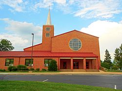
Colonial Park United Church of Christ
|
|||
|
|||

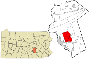
Location in Dauphin County and state of Pennsylvania.
|
|||
| Country | United States | ||
| State | Pennsylvania | ||
| County | Dauphin | ||
| Settled | 1717 | ||
| Incorporated | 1729 | ||
| Area | |||
| • Total | 28.17 sq mi (72.96 km2) | ||
| • Land | 28.17 sq mi (72.96 km2) | ||
| • Water | 0.00 sq mi (0.00 km2) | ||
| Population
(2020)
|
|||
| • Total | 53,501 | ||
| • Estimate
(2022)
|
54,089 | ||
| • Density | 1,899.2/sq mi (733.29/km2) | ||
| Time zone | UTC-5 (Eastern (EST)) | ||
| • Summer (DST) | UTC-4 (EDT) | ||
| Area code(s) | 717 and 223 | ||
| FIPS code | 42-043-45056 | ||
Lower Paxton is a township in Dauphin County, Pennsylvania, United States. It is a type of local government area. In 2020, about 53,501 people lived here. This makes it the most populated place in Dauphin County. It is also the 17th most populated place in Pennsylvania.
Lower Paxton Township is located about 76.6 kilometers (47.6 miles) southwest of Allentown. It is 9.4 kilometers (5.8 miles) northeast of Harrisburg. It is also 107.3 kilometers (66.7 miles) northwest of Philadelphia. The township was officially formed in 1767. It was created from a larger area called Paxton Township.
Contents
History of Lower Paxton Township
In 1729, a place called Paxtang Township was created. It was part of Lancaster County. The name "Paxtang" comes from an old American Indian word. It meant "standing water." Today, people use the spelling "Paxton" instead.
On March 4, 1785, Dauphin County was formed. Its borders were the same as Paxtang Township. Dauphin County was separated from Lancaster County. The name "Dauphin" honored the heir to the French throne. France had helped the United States in the Revolutionary War.
About two years later, in August 1787, Paxtang Township was divided. It was split into Upper Paxtang, Middle Paxtang, and Lower Paxtang.
Over the years, the township was divided even more. Hanover Township was created to the east in 1736. Upper Paxton Township was cut off to the north in 1767. What was left in 1767 became Lower Paxton Township. The city of Harrisburg was formed in 1791. Swatara Township was created in 1799. In 1878, Middle Paxton Township was formed from more land to the north.
Lower Paxtang Township used to include many areas. These areas are now Lower Swatara, Swatara, Lower Paxton, Derry, and Susquehanna townships. Lower Paxton has kept its current size since Susquehanna Township was formed from it on May 1, 1815.
Geography of Lower Paxton
Lower Paxton Township is in the south-central part of Dauphin County. To the west is Susquehanna Township. To the north is Middle Paxton Township. West Hanover and South Hanover townships are to the east. Swatara Township is to the south.
The eastern border of Lower Paxton Township follows Beaver Creek. This creek flows south into Swatara Creek. Swatara Creek then flows into the Susquehanna River. The northern border of the township is near Blue Mountain. This is the southernmost ridge of the Ridge-and-Valley Appalachians in this area.
The township covers about 72.8 square kilometers (28.1 square miles). All of this area is land.
There are four main communities in Lower Paxton Township. These are called census-designated places. Linglestown is in the northeast. About 6,334 people live there. Paxtonia is in the center. It has about 5,412 residents. Colonial Park is in the west and southwest. It is the largest with about 13,229 people. A small part of Progress is in the far west. Most of Progress is in Susquehanna Township.
Major highways run through the township. Interstate 83 goes through the western part. It ends at Interstate 81. Interstate 81 crosses the center of the township from west to east. You can get onto I-83 from Exit 50 (which is U.S. Route 22/Jonestown Road) and Exit 48 (Union Deposit Road). You can get onto I-81 from Exit 72, which is between Linglestown and Paxtonia.
Population Facts
| Historical population | |||
|---|---|---|---|
| Census | Pop. | %± | |
| 1930 | 2,792 | — | |
| 1940 | 4,157 | 48.9% | |
| 1950 | 6,546 | 57.5% | |
| 1960 | 17,618 | 169.1% | |
| 1970 | 26,517 | 50.5% | |
| 1980 | 34,830 | 31.3% | |
| 1990 | 39,162 | 12.4% | |
| 2000 | 44,424 | 13.4% | |
| 2010 | 47,360 | 6.6% | |
| 2020 | 53,501 | 13.0% | |
| 2022 (est.) | 54,703 | 15.5% | |
In 2000, there were 44,424 people living in Lower Paxton Township. There were 18,584 households. A household is a group of people living in one home. About 12,153 of these were families.
About 29% of households had children under 18 living there. About 53.2% were married couples. About 9.2% had a female head of household with no husband. About 28.8% of households were single people living alone. About 8.4% of homes had someone 65 years or older living alone. The average household had 2.35 people. The average family had 2.92 people.
The population was spread out by age. About 22.5% were under 18 years old. About 7.3% were between 18 and 24. About 30.9% were between 25 and 44. About 25.2% were between 45 and 64. And 14.1% were 65 years or older. The average age was 39 years.
Education
Children who live in Lower Paxton Township go to schools in the Central Dauphin School District.
See also
 In Spanish: Municipio de Lower Paxton para niños
 | Jewel Prestage |
 | Ella Baker |
 | Fannie Lou Hamer |


