Pueblorrico facts for kids
Quick facts for kids
Pueblorrico
|
|||
|---|---|---|---|
|
Municipality and town
|
|||
 |
|||
|
|||

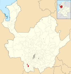
Location of the municipality and town of Pueblorrico in the Antioquia Department of Colombia
|
|||
| Country | |||
| Department | |||
| Subregion | Southwestern | ||
| Population
(2018)
|
|||
| • Municipality and town | 8,664 | ||
| • Urban | 4,450 | ||
| Time zone | UTC-5 (Colombia Standard Time) | ||
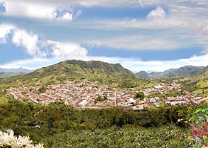
Pueblorrico is a town and municipality in Colombia. It's located in the southwestern part of the Antioquia Department. This area is known for its beautiful landscapes. Pueblorrico shares borders with several other towns. These include Salgar and Tarso to the north, Jericó to the east, Andes to the south, and Ciudad Bolívar and Hispania to the west.
Contents
History of Pueblorrico
In 1540, a Spanish lieutenant explored the lands along the Cauca River. This expedition, part of Marshal Jorge Robledo's troop, explored what is now Southwest Antioquia. This included the area where Pueblorrico stands today.
Later, in 1825, a group of settlers from Medellín bought large areas of land here. Gabriel Echeverri led this group. The land was later inherited by Santiago Santamaría.
Around 1869, the area became a corregimiento, which is like a local district. In 1907, it became a parish.
In 1911, Pueblorrico officially separated from the municipality of Jericó. It was then named a municipal fraction. The name "Pueblorrico" means "rich town." It is believed this name came from the first Spanish explorers. They found indigenous people with a lot of gold in the area.
Quick Facts About Pueblorrico
- Explorers: Spanish troops led by Jorge Robledo.
- Foundation Date: October 3, 1866.
- Became a Municipality: March 16, 1911.
- Founders: Early settlers.
- Nicknames: Sweet Municipality and Peaceful Haven of Southwest Antioquia.
Districts of Pueblorrico
The municipality of Pueblorrico is divided into 22 smaller areas called districts. These districts help organize the different communities within the municipality.
- Barcino
- California
- Cascabelito
- Castalia
- Corinto A
- Corinto B
- El Cedrón
- Hoyo Grande
- La Berrío
- La Envidia
- La Gómez
- La Pica
- La Unión
- Lourdes
- Morrón
- Mulatico
- Mulato
- Patudal
- San Francisco
- Santa Bárbara
- Sevilla
- Sinaí
Population and People
In 2018, the total population of Pueblorrico was 8,664 people. About 4,450 people lived in the urban (town) area. The remaining 4,214 people lived in the rural (countryside) areas.
In 2005, the literacy rate was 83.5%. This means that 83.5% of the people could read and write. In urban areas, the literacy rate was higher at 87.4%. In rural areas, it was 79.6%.
Ethnic Background
According to the 2005 census, most people in Pueblorrico are of mixed European and Indigenous heritage (Mestizos) or White. They make up 91.9% of the population. About 6.6% of the population is Black, and 1.5% are Indigenous people.
Economy and Work
The economy of Pueblorrico relies on several key activities.
- Agriculture: Farmers grow crops like coffee, plantains, cassava (yuca), panela (unrefined whole cane sugar), corn, and beans.
- Livestock: Raising animals is also important. This includes cattle, pigs, and horses.
- Commerce: Local businesses sell products from farming, manufacturing, and services. This helps the town's economy grow.
Festivals and Celebrations
Pueblorrico hosts several fun festivals throughout the year.
- Trapiche and Coffee Festival: This festival takes place on the first long weekend in June. It celebrates the local coffee and panela production.
- Farmer's Day Fair: This event honors the hard work of local farmers.
- Youth Home Festival / November Farmer's Festival: These festivals bring the community together, often with activities for young people and farmers.
Places to Visit and Explore
Pueblorrico offers many interesting places for visitors, from natural wonders to historical sites.
Nature and Outdoor Adventures
- El Salto De Los Monos Waterfall: This impressive waterfall is just 15 minutes from town. It has an 80-meter (about 260 feet) drop. It's near the El Cedrón district chapel.
- La Pirámide Hill: Located close to the town center, this hill is perfect for enjoying nature. It's a great spot for a picnic and gets its name from a pyramid-shaped structure found there.
- El Cedrón Valley Indigenous Petroglyph: In the El Cedrón district, you can find an ancient rock carving. This symbolic design was made by indigenous people long ago. It's the only one identified in the municipality.
- La Trocha Ecological Reserve: This is a cloud forest filled with many different plants and animals. It's a wonderful place for bird watching and hiking on trails of various difficulty levels.
Religious and Spiritual Sites
- El Gólgota Hill: This hill is considered the town's guardian. It's a pilgrimage site where people go for spiritual reasons. From its top, you can see about 60% of the nearby Southwest region. It's about 50 minutes from the town center.
- Cristo Rey Hill: This hill is good for a relaxed visit. It offers a view of the entire town. There's also a monument honoring Christ the King here.
- El Asomadero: This is another pilgrimage spot. It has a monument dedicated to the Virgin of Carmen. She is the patron saint of drivers in Colombia and Venezuela. She is highly respected by the people of Pueblorrico.
- San Antonio de Padua Parish Church: Construction of this church started in 1931 and finished in 1965. It has three main sections (naves), with a tall tower and bell tower over the central part.
Town and Historical Landmarks
- Joaquín López Gaviria Cultural House: Named after the town's founder, this house is a hub for culture and art. It hosts various schools for different art forms.
- "100 Years of Pueblorrico" Mural: This mural is carved into a ravine. It shows important parts of the municipality's economy, famous people, and tourist spots. Local artist William Peláez Agudelo created it for the town's 100th anniversary as a municipality in 1911.
- Historical Museum and Municipal Library: This museum displays old items that tell the story of Pueblorrico's history, culture, and traditions. The library has many historical and educational books for everyone. The museum is part of the Antioquia Museum Network.
- Simón Bolívar Main Park: This park gives the town a modern feel while keeping its traditional charm. It features a statue honoring "The Mule Driver," a symbol of the region.
- Jairo Alberto Gallego Sports Complex: This is a great place for sports and recreation. It has a micro-soccer field, a covered arena, a soccer stadium, an outdoor gym, and playgrounds for kids. There are also children's and semi-Olympic swimming pools.
See also
 In Spanish: Pueblorrico para niños
 | Laphonza Butler |
 | Daisy Bates |
 | Elizabeth Piper Ensley |


