Puerto Libertad facts for kids
Quick facts for kids
Puerto Libertad
|
|
|---|---|
|
Municipality and village
|
|
| Country | |
| Province | Misiones Province |
| Area | |
| • Total | 336 sq mi (871 km2) |
| Elevation | 750 ft (230 m) |
| Population
(2001)
|
|
| • Total | 6,143 |
| • Density | 20/sq mi (7/km2) |
| Time zone | UTC−3 (ART) |
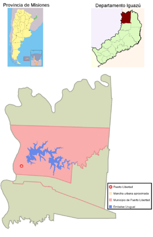
Puerto Libertad is a village and a municipality (which is like a local government area) located in the north-eastern part of Argentina. It is found in the Misiones Province, a beautiful area known for its natural wonders. This town is about 25 kilometers (around 15 miles) south of the famous Iguazu Falls, which are huge waterfalls, and only 5 kilometers (about 3 miles) from the Paraná River. According to a 2001 census, about 6,143 people live there.
Contents
History of Puerto Libertad
Early Settlement and Growth
A settlement began in this area in the late 1800s. This happened when factories arrived that needed people to harvest yerba mate. Yerba mate is a plant used to make a popular drink in South America. These factories were located near the Paraná River.
The town was first called Villa Veinticinco de Mayo. It grew steadily over time. By 1927, it had its first school, and a year later, a post office was opened. A census in 1929 showed that 1,190 people lived in the town.
Changing Names and Development
In 1950, the first local development committee was formed. It was named "17 de Octubre" to honor the Peronist Party, a political group in Argentina. However, in 1955, a military coup (when the military takes control of the government) overthrew the leader, Juan Domingo Perón. Because of the political meaning of the name "17 de Octubre", the town was renamed "Libertad" (which means "Freedom"). By 1971, the town had grown to about 3,500 residents.
More recently, an important economic project was completed near the village. This was the construction of the Uruguaí Dam, which is about 5 kilometers (3 miles) away on the Uruguaí creek. This dam helps with electricity and water management for the region.
See also
 In Spanish: Puerto Libertad (Misiones) para niños
 | William M. Jackson |
 | Juan E. Gilbert |
 | Neil deGrasse Tyson |


