
Puerto Libertad, Sonora facts for kids
Quick facts for kids
Puerto Libertad
|
|
|---|---|

Puerto Libertad
Location in Mexico

Puerto Libertad
Location in Sonora
|
|
| Country | |
| State | Sonora |
| Municipality | Pitiquito |
| Population
(2010)
|
|
| • Total | 2,782 |
Puerto Libertad is a town and port located in the Mexican state of Sonora, Mexico. You can find it on the northern coast of the Gulf of California, within the Pitiquito area.
Contents
How Many People Live Here?
In 2005, about 2,823 people lived in Puerto Libertad. This included 1,489 men and 1,334 women.
What Does Puerto Libertad Do?
Puerto Libertad is a busy place known for its fishing. It is also home to one of Mexico's biggest power plants. This plant is run by the Comisión Federal de Electricidad, which is the national electricity company.
Powering the Future
Because of the large power plant, Puerto Libertad is a special spot for new energy ideas. One exciting project involves using tiny plants called algae to make fuel. This fuel, called ethanol, can be made from the power plant's exhaust.
Two companies, Algenol from America and Biofields from Mexico, are working together on this. Puerto Libertad is also developing a solar energy project. This project is being built by Sonora Energy Group Hermosillo, S.A. de C.V.
A Growing Tourist Spot
Puerto Libertad is located in the Sonoran Desert. The mix of desert and sea makes it a very unique and appealing place. More and more tourists are discovering its beauty, making tourism a growing part of its economy.
Where is Puerto Libertad?
Puerto Libertad is located at specific map coordinates: 29°54'15" North and 112°40'59" West. It sits about 10 meters (33 feet) above sea level.
The town is about 416 kilometers (258 miles) away from Hermosillo, which is the capital city of Sonora. A road along the coast connects Puerto Libertad to Hermosillo.
What's the Weather Like?
Puerto Libertad has a desert climate. This means it's usually very hot and dry, with very little rain. This type of climate is called BWh in the Köppen climate classification system.
| Climate data for Puerto Libertad, Sonora (1981–2010, extremes (1960–present) | |||||||||||||
|---|---|---|---|---|---|---|---|---|---|---|---|---|---|
| Month | Jan | Feb | Mar | Apr | May | Jun | Jul | Aug | Sep | Oct | Nov | Dec | Year |
| Record high °C (°F) | 29.0 (84.2) |
32.0 (89.6) |
33.5 (92.3) |
41.0 (105.8) |
42.0 (107.6) |
44.0 (111.2) |
43.0 (109.4) |
44.0 (111.2) |
44.0 (111.2) |
42.0 (107.6) |
38.0 (100.4) |
32.2 (90.0) |
44.0 (111.2) |
| Mean daily maximum °C (°F) | 19.9 (67.8) |
21.3 (70.3) |
23.4 (74.1) |
26.6 (79.9) |
29.4 (84.9) |
33.0 (91.4) |
34.9 (94.8) |
35.5 (95.9) |
34.6 (94.3) |
30.0 (86.0) |
24.7 (76.5) |
20.5 (68.9) |
27.8 (82.0) |
| Daily mean °C (°F) | 13.5 (56.3) |
14.8 (58.6) |
17.0 (62.6) |
20.0 (68.0) |
22.9 (73.2) |
27.1 (80.8) |
30.6 (87.1) |
31.1 (88.0) |
29.4 (84.9) |
23.8 (74.8) |
18.1 (64.6) |
14.1 (57.4) |
21.9 (71.4) |
| Mean daily minimum °C (°F) | 7.2 (45.0) |
8.3 (46.9) |
10.6 (51.1) |
13.3 (55.9) |
16.4 (61.5) |
21.1 (70.0) |
26.4 (79.5) |
26.8 (80.2) |
24.2 (75.6) |
17.7 (63.9) |
11.4 (52.5) |
7.7 (45.9) |
15.9 (60.6) |
| Record low °C (°F) | −6.0 (21.2) |
0.0 (32.0) |
1.0 (33.8) |
3.0 (37.4) |
4.5 (40.1) |
7.5 (45.5) |
12.5 (54.5) |
13.5 (56.3) |
11.0 (51.8) |
2.5 (36.5) |
1.5 (34.7) |
−1.0 (30.2) |
−6.0 (21.2) |
| Average precipitation mm (inches) | 13.1 (0.52) |
6.8 (0.27) |
10.3 (0.41) |
1.9 (0.07) |
0.0 (0.0) |
0.3 (0.01) |
10.9 (0.43) |
13.3 (0.52) |
12.5 (0.49) |
16.8 (0.66) |
8.3 (0.33) |
21.2 (0.83) |
115.4 (4.54) |
| Average precipitation days (≥ 0.1 mm) | 2.3 | 1.3 | 1.2 | 0.5 | 0.0 | 0.2 | 1.7 | 1.8 | 1.3 | 1.3 | 1.3 | 2.5 | 15.4 |
| Source: Servicio Meteorológico Nacional | |||||||||||||
Images for kids
-
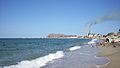
Beach and power plant at Puerto Libertad

See also
 In Spanish: Puerto Libertad (Sonora) para niños
