
Puerto Píritu facts for kids
Quick facts for kids
Puerto Pìritu
|
|||
|---|---|---|---|
 |
|||
|
|||
| Nickname(s):
Enchanted land
|
|||
.svg)
Puerto Píritu
Location in Venezuela
|
|||
| Country | Venezuela | ||
| States | Anzoátegui | ||
| Municipalities | Fernando de Peñalver Municipality | ||
| Founded | 1513 | ||
| Elevation | 8 m (26 ft) | ||
| Population
(2001)
|
|||
| • Total | 11,000 approx. | ||
| • Demonym | Pìriteño(a) | ||
| Time zone | UTC−4 (VET) | ||
| Postal code |
6022
|
||
| Area code(s) | 281 | ||
| Climate | BSh | ||
| Website | [1] | ||

.svg)
Puerto Píritu is a city in Venezuela. It's on the north-central coast of Anzoátegui State. About 11,000 people live here. It's the main city of the Fernando de Peñalver Municipality.
The city is about 46 kilometers (28 miles) from Barcelona. Barcelona is the capital of the state. You can reach Barcelona in about 25 minutes by car.
Contents
History of Puerto Píritu
Puerto Píritu was first started in 1513. It was called "El Manjar" back then. But it was left empty a few years later.
Many old colonial buildings still stand in the city's historic center. The modern history of Puerto Píritu began in 1652. This was when Franciscan missionaries arrived.
In the 1600s and 1700s, Puerto Píritu was a key spot. It was used for people to enter and leave the area. This helped with settlement and spreading new ideas in what is now Anzoátegui State.
The city really started to grow in the mid-1800s. Many families from Margarita Island moved here. This helped Puerto Píritu become a major trading port. It was a place where goods from the plains of Guárico and the Unare River basin were shipped out. By 1928, it was an important district, much like the Peñalver Municipality is today.
Economy and Jobs
The main ways people in Puerto Píritu make money are through tourism, fishing, and trade. These activities help the city's economy grow.
Geography and Location
Puerto Píritu is located very close to sea level. Its altitude is only 8 meters (about 26 feet) above the sea.
The city's exact location is at 10.04495 degrees North latitude and 65.033272 degrees West longitude.
Climate and Weather
Puerto Píritu has a hot semi-arid climate. This means it is generally hot and dry. It gets less rain than other places.
| Climate data for Puerto Píritu, Venezuela | |||||||||||||
|---|---|---|---|---|---|---|---|---|---|---|---|---|---|
| Month | Jan | Feb | Mar | Apr | May | Jun | Jul | Aug | Sep | Oct | Nov | Dec | Year |
| Mean daily maximum °C (°F) | 31.1 (88.0) |
31.7 (89.1) |
32.2 (90.0) |
32.2 (90.0) |
32.8 (91.0) |
31.7 (89.1) |
31.7 (89.1) |
31.7 (89.1) |
32.2 (90.0) |
32.8 (91.0) |
32.2 (90.0) |
31.7 (89.1) |
32.0 (89.6) |
| Mean daily minimum °C (°F) | 20.0 (68.0) |
20.6 (69.1) |
21.7 (71.1) |
22.8 (73.0) |
23.3 (73.9) |
22.8 (73.0) |
22.8 (73.0) |
22.8 (73.0) |
22.8 (73.0) |
22.8 (73.0) |
22.2 (72.0) |
21.1 (70.0) |
22.1 (71.8) |
| Average rainfall mm (inches) | 7.6 (0.30) |
2.5 (0.10) |
2.5 (0.10) |
7.6 (0.30) |
48.3 (1.90) |
104.1 (4.10) |
119.4 (4.70) |
121.9 (4.80) |
83.8 (3.30) |
58.4 (2.30) |
43.2 (1.70) |
22.9 (0.90) |
622.2 (24.5) |
| Source: [The Weather Channel Interactive, Inc.] | |||||||||||||
Tourism and Attractions
Puerto Píritu is a popular place for tourists. Like other cities in Anzoátegui State, it has beautiful beaches and lagoons. The area has less plant life, but it makes up for it with wide, open beaches. Most visitors come from within Venezuela.
The eastern coast of Anzoátegui has newer tourist facilities. The resort area of Puerto Píritu has about 600 meters (nearly 2,000 feet) of beaches. The water can look a bit cloudy or brown when the sea is rough. Services at the beach include restaurants, and you can rent sunshades and umbrellas.
People enjoy Puerto Píritu for its pretty views, interesting plants and animals, and its lovely beaches.
Schools in Puerto Píritu
There are several schools in Puerto Píritu for students to learn and grow:
- EU Pedro Rolingson Herrera
- U.E.P mother Candelaria
- U.E.P educational Institute Puerto Píritu
- EU Francisco Fajardo
- U.E.P. Edgar Marques
- U.E.P. Christ Jose
- EU José f. laya
- EU Pedro Celestino Muñóz
- Naval Lyceum GD José Antonio Anzoátegui
Images for kids
-
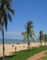
Beach of Puerto Píritu. Main source of tourism

See also
 In Spanish: Puerto Píritu para niños
