
Punta La Entallada Lighthouse facts for kids
| Location | Tuineje Fuerteventura Canary Islands Spain |
|---|---|
| Coordinates | 28°13′49″N 13°56′55″W / 28.230412°N 13.948550°W |
| Year first constructed | 1955 |
| Construction | rubble masonry tower |
| Tower shape | square tower |
| Height | 12 metres (39 ft) |
| Focal height | 196 metres (643 ft) |
| Range | 21 nautical miles (39 km; 24 mi) |
| Spain number | ES-12190 |
The Punta La Entallada Lighthouse (also called La Entallada Lighthouse) is a tall, active lighthouse found on the beautiful Canary island of Fuerteventura. It stands on the eastern coast, close to the small village of Las Playitas in Tuineje, Spain. This lighthouse helps ships navigate the waters safely.
Contents
Building the Lighthouse
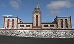
The Punta La Entallada Lighthouse was finished in 1955. It was designed by an architect named Carlos Alcon. He used ideas from Moorish architecture to create a very special and unique building.
Unique Design Features
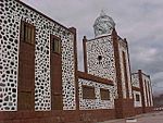
The lighthouse has a striking look because it uses different colored stones and white plaster. The colored stone came from a village called Tetir, located in the middle of the island. This mix of materials makes the lighthouse stand out.
How the Lighthouse Looks
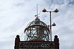
On the side facing the sea, the lighthouse has three square towers. The middle tower is the tallest and holds the lantern dome. This dome is made completely of glass, allowing the light to shine brightly. On the side facing the land, the building stretches out into two "arms." These arms create a central courtyard that is surrounded on three sides by an arched walkway.
Lighthouse Power and Purpose
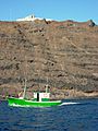
This lighthouse is built on very high cliffs. Its light shines from 196 meters (about 643 feet) above the sea. This makes it the third highest lighthouse in the Canary Islands!
How Far Can the Light Be Seen?
The light from Punta La Entallada Lighthouse can be seen from 21 nautical miles away. That's about 39 kilometers or 24 miles! The light flashes white three times every eighteen seconds, helping sailors know exactly where they are.
A Landmark for Visitors
Because of its amazing location and great views, the lighthouse is now a popular spot for tourists. There's a special viewpoint and a car park, so visitors can easily come and enjoy the scenery. Many people visit to see the lighthouse and the ocean.
Closest Point to Africa
The Punta La Entallada Lighthouse is considered the closest point in the Canary Islands to Africa. It's only about 100 kilometers (62 miles) to the east, across the ocean.
More Than Just a Sea Light
Besides guiding ships, this lighthouse has also helped airplanes in the past. It was used as an "aerial beacon" to direct aircraft from Gando airfield towards the Spanish Sahara. This included planes used during the Ifni conflict.
Lighthouse on Stamps
In 2011, the Punta La Entallada Lighthouse was featured on a set of six special stamps. These stamps were released by Correos, which is the Spanish postal service. It was a way to celebrate this important landmark.
Images for kids

-
Front elevation
-
Glass lantern
-
Building details
-
View from the Sea


See also
 In Spanish: Faro de Punta La Entallada para niños
- List of lighthouses in Spain
- List of lighthouses in the Canary Islands
