Qikiqtaaluk (Foxe Basin) facts for kids

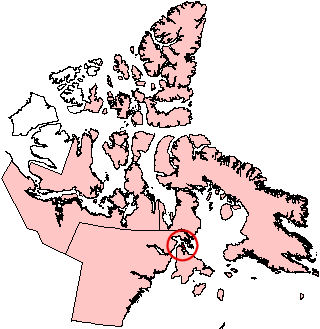
Location of Qikiqtaaluk on a Nunavut map
|
|
| Geography | |
|---|---|
| Location | Foxe Basin |
| Coordinates | 65°47′31″N 84°52′28″W / 65.79194°N 84.87444°W |
| Archipelago | Arctic Archipelago |
| Area | 789 km2 (305 sq mi) |
| Highest point | 368 m (1,207 ft) |
| Administration | |
|
Canada
|
|
| Nunavut | Nunavut |
| Region | Kivalliq |
| Demographics | |
| Population | 0 |
Qikiqtaaluk (ᕿᑭᖅᑖᓗᒃ), also known as White Island, is a large island in Canada's Arctic. It is part of the Arctic Archipelago and is located in the Kivalliq Region of Nunavut. No people live on Qikiqtaaluk.
The island is found in Foxe Basin, just north of Southampton Island. Qikiqtaaluk covers an area of 789 square kilometers (about 305 square miles).
Geography of Qikiqtaaluk
Qikiqtaaluk is separated from Southampton Island by two narrow waterways. These are Comer Strait to the west and Falcon Strait to the south. Both are less than 2 kilometers (1.2 miles) wide.
The island has several capes, which are points of land sticking out into the sea. These include Cape Middleton, Cape Frigid, and Cape Deas. On the eastern coast, you can find Whale Sound and Toms Harbour. The Frozen Strait is also nearby.
Surrounding Islands and Features
Qikiqtaaluk is surrounded by many smaller islands. Some of these are Passage Island, Whale Island, Seekoo Island, and Nas Island. There are also many unnamed islands around it.
The highest points on Qikiqtaaluk are two peaks. One reaches 368 meters (1,207 feet) high, and the other is 367 meters (1,204 feet) high. The island has many lakes, with the largest one being 17 kilometers (11 miles) long.
See also
 In Spanish: Isla White para niños
 | John T. Biggers |
 | Thomas Blackshear |
 | Mark Bradford |
 | Beverly Buchanan |


