Quebec Run facts for kids
Quick facts for kids Quebec Run |
|
|---|---|

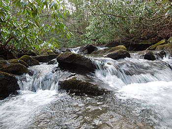
Waterfall along Quebec Run
|
|
|
Location of Quebec Run mouth
|
|
| Other name(s) | Tributary to Big Sandy Creek |
| Country | United States |
| State | Pennsylvania |
| County | Fayette |
| Physical characteristics | |
| Main source | Brownfield Hollow divide about 2 miles northeast of Wymps Gap, Pennsylvania 2,240 ft (680 m) 39°45′51″N 079°42′25″W / 39.76417°N 79.70694°W |
| River mouth | Big Sandy Creek about 4 miles southwest of Elliottsville, Pennsylvania 1,550 ft (470 m) 39°44′12″N 079°39′35″W / 39.73667°N 79.65972°W |
| Length | 3.74 mi (6.02 km) |
| Basin features | |
| Progression | east and southeast |
| River system | Monongahela River |
| Basin size | 14.33 square miles (37.1 km2) |
| Tributaries |
|
| Bridges | none |
Quebec Run is a small stream, about 3.74 mi (6.02 km) long, located in Fayette County, Pennsylvania. It flows into a larger stream called Big Sandy Creek. Interestingly, this is the only stream in the entire United States with the name Quebec Run!
What's in a Name?
Sometimes, streams and places have more than one name. Quebec Run has also been known by another name in the past.
- Mill Run
This information comes from the Geographic Names Information System, which keeps track of names for places.
Where Does it Flow?
Quebec Run starts its journey about 2 miles northeast of a place called Wymps Gap, Pennsylvania. From there, it flows towards the east and then the southeast. It eventually meets up with Big Sandy Creek, which is about 4 miles southwest of Elliottsville.
The Land Around the Stream
The area of land that Quebec Run drains is called its watershed. This watershed covers about 14.33 square miles (37.1 km2) of land. It gets a good amount of rain each year, around 50.9 inches. Most of this area, about 94%, is covered in forests, which helps keep the water clean and healthy.
 | Jewel Prestage |
 | Ella Baker |
 | Fannie Lou Hamer |


