
RAN Station 9, Pinkenba facts for kids
Quick facts for kids RAN Station 9, Pinkenba |
|
|---|---|

Generator hut, 2015
|
|
| Location | Myrtletown Reserve, Pinkenba, City of Brisbane, Queensland, Australia |
| Design period | 1939 - 1945 (World War II) |
| Built | 1940s |
| Architectural style(s) | Brutalism |
| Official name: RAN Station 9, Pinkenba (Myrtletown) | |
| Type | state heritage (built) |
| Designated | 17 July 2008 |
| Reference no. | 602448 |
| Significant period | 1940s |
| Significant components | engine/generator shed/room / power supply, septic system, observation post (military), slab/s - concrete |
| Lua error in Module:Location_map at line 420: attempt to index field 'wikibase' (a nil value). | |
RAN Station 9, Pinkenba was a special naval station. It helped watch for submarines in the Brisbane River. This important site is in Myrtletown Reserve, Pinkenba, Queensland. It was built in the 1940s during World War II. Today, it is a heritage-listed site. This means it is protected because of its historical importance.
Contents
A Look Back: Why RAN Station 9 Was Built
The Royal Australian Navy (RAN) Station 9 was a key part of Australia's defence. It helped protect Moreton Bay and the Brisbane River. This was especially important during World War II. The station used special technology to find enemy ships.
Protecting Brisbane During World War II
During World War II, Australia needed strong defences. The main way into the Brisbane River was a winding path. This path was called the Northwest Channel. Coastal forts and naval stations guarded this route. They watched for any enemy ships or submarines.
Moreton Bay had ten RAN stations. Each station had a different job. RAN Station 9 was one of these important defence points. It was built to detect hidden threats.
How RAN Station 9 Detected Submarines
RAN Station 9 used two main ways to find enemy vessels. These were the indicator loop and the photo-electric (PE) beam.
The Indicator Loop: Finding Hidden Subs
An indicator loop was like an invisible tripwire under the water. It was a long wire laid on the seabed. When a metal object, like a submarine, passed over it, it created a small electric current. This current was detected at the station.
The loop could tell if something was there. If no ship was seen on the surface, it meant a submarine was likely present. This system helped protect against surprise attacks.
The Photo-Electric Beam: Spotting Surface Ships
The PE beam was another clever defence. It was a light beam sent across the water. This beam was mostly invisible to the eye. If a ship sailed through the beam, it would break the connection.
When the beam was broken, an alarm would sound at RAN Station 9. A flashing red light would also come on. This told the operators that a surface vessel was entering the river. A searchlight would then turn on to check the area.
Building and Operating RAN Station 9
The indicator loop cables were laid across the Brisbane River. They stretched from RAN Station 9 to Fisherman Islands. If a submarine was found, a signal went to another station. This signal would help raise a special boom. The boom was a large cable across the river. It stopped enemy ships from passing.
The PE beam was finished in September 1943. RAN Station 9 started working in January 1944. Luckily, the station never detected any enemy intruders. The indicator loop was removed in June 1945. This was after the war ended.
What RAN Station 9 Looks Like Today

Today, you can still see parts of RAN Station 9. These structures are in Myrtletown Reserve. They are made of strong concrete. They stand out in the peaceful riverside park.
The Control Hut
The control hut is the larger of the two main buildings. It is made of thick concrete walls. This building held the equipment for the indicator loop and PE beam. It has an open entry area and several rooms. One room had a narrow window. This window was for observing the river. Another room had a large opening. This opening was where the PE beam was received.
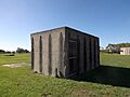
The Generator Hut
Next to the control hut is the generator hut. This smaller concrete building held the power generator. This generator provided electricity for the station. It has long, narrow windows. These windows are protected by concrete hoods. Inside, you can still see a concrete base. This is where the generator once sat.
Other Remains at the Site

You can also see other concrete remains. These are mostly flat concrete slabs. They show where other buildings once stood. These buildings included the living quarters and a mess hall. There are also two brick structures. These were likely part of the septic system for the living areas.
Why RAN Station 9 is Important
RAN Station 9 is listed on the Queensland Heritage Register. This means it is a very important historical site.
A Piece of Queensland's History
The buildings at RAN Station 9 show how Queensland was defended during World War II. They are a reminder of the efforts made to protect the Brisbane River. The station was part of a big defence system. This system included forts, minefields, and other detection devices.
A Rare Defence Site
RAN Station 9 was one of only three PE beam defence sites in Australia. The other two were in Sydney and Melbourne. This makes the Pinkenba site quite rare and special.
Showing How Defence Stations Worked
The layout of RAN Station 9 shows how these wartime stations operated. Its location by the river was perfect for detecting enemy ships. The design of the control hut's rooms also shows their purpose. For example, the observation window helped operators watch the river.
A Poignant Reminder
The concrete buildings stand quietly by the river today. They are a strong reminder of a time of war. They show the efforts made to keep Australia safe.
Images for kids
-
Control hut, 2015
-
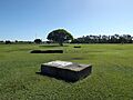
Park and concrete slabs, 2015
