RRH Portreath facts for kids
Quick facts for kids RRH Portreath
|
|
|---|---|
| Part of RAF St Mawgan | |
| Near Portreath, Cornwall in England | |

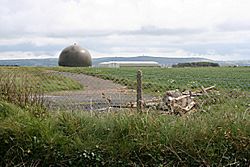
Radar dome at RRH Portreath
|
|
|
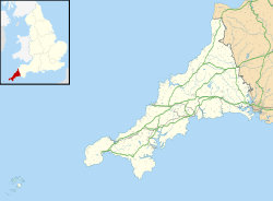
Shown within Cornwall
|
|
| Coordinates | 50°16′17″N 005°15′48″W / 50.27139°N 5.26333°W |
| Type | Remote Radar Head |
| Area | 351 hectares (870 acres) |
| Site information | |
| Owner | Ministry of Defence |
| Operator | Royal Air Force |
| Controlled by | No. 1 Group (Air Combat) |
| Condition | Operational |
| Radar type | BAE Systems Type 102 Air Defence Radar |
| Site history | |
| Built | 1940 |
| In use | 1941–1950 (Royal Air Force) c.1950–1980 (Chemical Defence Establishment) 1980 – present (Royal Air Force) |
| Garrison information | |
| Occupants | Radar Flight (South) |
Remote Radar Head Portreath or RRH Portreath is a special radar station. It is run by the Royal Air Force (RAF). This important base is located near the coast in Cornwall, England. It is about 1.25 kilometers (0.78 miles) north-east of the village of Portreath.
The radar at RRH Portreath is inside a protective dome. This dome looks like a giant golf ball. The radar helps to watch the skies far out over the south-western parts of the United Kingdom. It helps keep our country safe.
History of RAF Portreath
The station was first known as RAF Portreath. It was built in 1940 and opened in March 1941. During World War II, it was a very busy place.
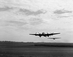
At first, it was a base for RAF Fighter Command planes. From October 1941, it became a stop-over for aircraft. These planes were flying to or from North Africa and the Middle East. It also hosted units from the United States Army Air Forces and the Royal Canadian Air Force. Later, it became a base for RAF Coastal Command.
After the war ended, the base became less active. In May 1950, the RAF handed it back to the government. Many different RAF squadrons and units were based here during the war. They played a big part in the war effort.
A Time of Change: Chemical Research
After the RAF left in 1950, the base was renamed Nancekuke. It became a special research site for the Chemical Defence Establishment (CDE). This group studied chemical defence.
In the early 1950s, a small facility at Nancekuke made a chemical called Sarin. This was done for research and to prepare for national defence. About 20 tons of Sarin were produced between 1954 and 1956. Nancekuke was important for storing chemicals for the UK's defence during the Cold War. Small amounts of another chemical, VX, were also made there for testing.
By the late 1950s, the chemical production part of the site was closed down. However, it was kept ready in case it was needed again. In 2003, work began to clean up the site. This made sure it was safe for the future.
Modern Radar Station
Many of the old CDE buildings were taken down between 1979 and 1980. For a few years, some buildings were used by a company that developed small arms ammunition. They even built a firing range for testing.
The RAF returned to parts of the site in October 1980. It became a manned radar station again. This station helped with UK Air Surveillance. In 1986, an underground control center was built. This was part of a new system called UKADGE (United Kingdom Air Defence and Ground Environment).
New radar systems and communication tools were added in the mid-1980s. In the late 1990s, the station became remote-controlled. This means people didn't need to be there all the time. The main radar was updated. Today, the radar used at Portreath is a Type 102 Air Defence Radar.
In 2020, the Ministry of Defence started a big project called HYDRA. This project is upgrading radar sites across the UK. It includes new communication buildings, radar towers, and better security.
The area around the base is sometimes used for car rallying. Even though Portreath sends its radar data to other UK control centers, its main administrative base is RAF St. Mawgan.
See also
- Chemical weapons and the United Kingdom
- Improved United Kingdom Air Defence Ground Environment – A UK air defence radar system used from the 1990s to the 2000s.
- Linesman/Mediator – An older UK air defence radar system used between the 1960s and 1984.
- List of Royal Air Force stations
- NATO Integrated Air Defense System
 | James Van Der Zee |
 | Alma Thomas |
 | Ellis Wilson |
 | Margaret Taylor-Burroughs |


