Raspberry Island (Minnesota) facts for kids
|
Nickname: Navy Island
|
|
|---|---|

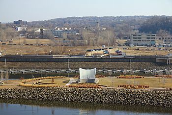
The east side of Raspberry Island in 2012
|
|
| Etymology | Endemic wild raspberries |
| Geography | |
| Coordinates | 44°56′32″N 93°05′26″W / 44.9421879°N 93.0904963°W |
| Adjacent bodies of water | Mississippi River |
| Area | 8,094 m2 (87,120 sq ft) |
| Highest elevation | 212 m (696 ft) |
| Administration | |
|
United States
|
|
| State | Minnesota |
| City | Saint Paul |
Raspberry Island is a small island located in the Mississippi River in Saint Paul, Minnesota. It used to be called Navy Island. Since 1885, buildings for the Minnesota Boat Club have been on the island. The club's current boathouse was built in 1910. From 1949 to 1968, the United States Navy used the island. Today, Raspberry Island is a fun place with walking paths, an open area called a plaza, and a stage for concerts called a bandshell.
What is Raspberry Island's History?
Raspberry Island got its first name from the wild raspberries that grew there. This name appeared on the first map of downtown Saint Paul in 1851.
In 1885, a wooden building was put on the island for the Minnesota Boat Club. This club is the oldest sports club in Minnesota! In 1910, the club built a new home. It was designed by George H. Carsley in a special style called Mission Revival. This building is still used today.
The island kept the name Raspberry Island until 1949. That's when the United States Navy built a small base on the eastern side of the island. The Boat Club owned the western side. Because of the Navy base, the island became known as Navy Island.
In 1965, a big flood washed away the 150-foot (46 m) wooden bridge that connected the island to the mainland. The bridge floated downstream! The Navy left the island in 1968. During the 1970s and 1980s, many people who worked in downtown Saint Paul used the island as a place to park their cars. In 1995, the Saint Paul City Council voted to change the name back to Raspberry Island.
Sometimes, large piles of logs, called log jams, have gathered near the bridge that connects the island to the mainland. This happened in 2010 and again in 2013. These log jams made it hard for local boaters because the logs blocked their docking spots. The City of Saint Paul paid to have the logs removed both times.
What Does Raspberry Island Look Like?
Raspberry Island is located under the Wabasha Street Bridge. It is about 2 acres (8,100 m²) in size. The island sits about 696 feet (212 m) above sea level. The Raspberry Island Bridge connects it to the mainland.
How Was Raspberry Island Improved?
From 2007 to 2008, Raspberry Island got a big makeover. Before this, it was described as a "scruffy, barren place." The renovation made the island much nicer and added many new features.
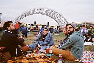
The shoreline was made stronger with limestone riprap, which are rocks used to protect the land from water. Public restrooms were added to the Boat Club building. A new plaza, walking trails, and a grassy area for events were built near a new bandshell. This bandshell was designed for Saint Paul's Schubert Club, a music organization. Also, 131 new trees and many other plants like shrubs, grasses, and flowers were planted. This whole project cost $5 million.
Local TV station WCCO-TV said the island's Boat Club is one of Minnesota's best places for a wedding reception. They noted that even though it's downtown, you don't hear the city's noise on the island.
 | Percy Lavon Julian |
 | Katherine Johnson |
 | George Washington Carver |
 | Annie Easley |


