Ravelo Municipality facts for kids
Quick facts for kids
Ravelo Municipality
|
|
|---|---|
|
Municipality
|
|

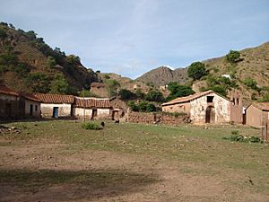
The small village of Toroca in the Ravelo Municipality
|
|

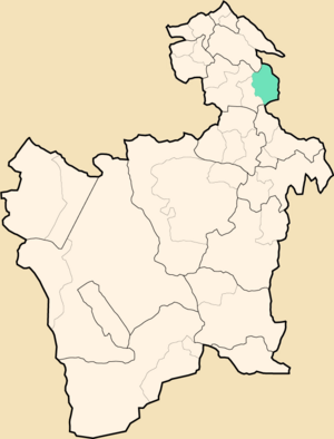
Location within Potosí Department
|
|
| Country | |
| Department | Potosí Department |
| Province | Chayanta Province |
| Seat | Ravelo |
| Population
(2001)
|
|
| • Total | 20,536 |
| • Ethnicities | Quechua |
| Time zone | UTC-4 (BOT) |
Ravelo Municipality is a special area in Bolivia. It's like a district or a county. It is part of the Chayanta Province in the Potosí Department. The main town, or "seat," of this municipality is called Ravelo.
Contents
Exploring the Geography of Ravelo
Geography is the study of Earth's physical features. This includes mountains, rivers, and landforms. Ravelo Municipality has many tall mountains. These mountains shape the landscape of the area.
Some of the highest mountains in Ravelo Municipality include:
- Apachita
- Chullpa Urqu
- Ch'iyar Jaqhi
- Jatun Lluqhi
- Jatun Urqu
- Katariri
- Kuntur Qaqa
- Markawi
- Palta Urqu
- Pata Urqu
- Puka Q'asa
- Puka Urqu
- Q'illu Wasi
- Sankayu
- Sikuyayuq
- Tullu Muqu
- Ura Urqu
- Urqu Pata
- Wathiya Punta
- Wayra Wasi
- Wichhu Qullu
- Wisk'achani
- Wisk'achani Punta
- Yana Qaqa
- Yana Urqu
- Yuraq Urqu
How Ravelo is Divided
A municipality is often divided into smaller parts. These smaller areas are called cantons. They help organize the region. Ravelo Municipality has six main cantons.
The municipality is made up of these cantons:
- Antora
- Huaycoma
- Pitantora
- Ravelo
- Tomoyo
- Toroca
The People of Ravelo
Most people living in Ravelo Municipality are indigenous. This means their families have lived in this land for a very long time. Many of them are from the Quechua group.
The table below shows the different ethnic groups in Ravelo. An ethnic group is a community or population group. They share a common cultural background or descent.
| Ethnic group | % |
|---|---|
| Quechua | 94.4 |
| Aymara | 0.3 |
| Guaraní, Chiquitos, Moxos | 0.1 |
| Not indigenous | 5.2 |
| Other indigenous groups | 0.1 |
Understanding Ravelo's Climate
Climate describes the usual weather conditions in a place over a long time. This includes temperature, rainfall, and humidity. Ravelo has its own unique climate patterns.
| Climate data for Ravelo, elevation 3,200 m (10,500 ft) | |||||||||||||
|---|---|---|---|---|---|---|---|---|---|---|---|---|---|
| Month | Jan | Feb | Mar | Apr | May | Jun | Jul | Aug | Sep | Oct | Nov | Dec | Year |
| Mean daily maximum °C (°F) | 19.9 (67.8) |
19.6 (67.3) |
19.5 (67.1) |
20.1 (68.2) |
20.4 (68.7) |
19.8 (67.6) |
19.7 (67.5) |
20.6 (69.1) |
21.1 (70.0) |
21.6 (70.9) |
21.7 (71.1) |
21.0 (69.8) |
20.4 (68.8) |
| Daily mean °C (°F) | 13.6 (56.5) |
13.4 (56.1) |
13.1 (55.6) |
12.6 (54.7) |
10.9 (51.6) |
9.4 (48.9) |
9.3 (48.7) |
11.2 (52.2) |
12.5 (54.5) |
13.8 (56.8) |
14.1 (57.4) |
14.0 (57.2) |
12.3 (54.2) |
| Mean daily minimum °C (°F) | 7.4 (45.3) |
7.2 (45.0) |
6.8 (44.2) |
5.2 (41.4) |
1.4 (34.5) |
−1.1 (30.0) |
−1.1 (30.0) |
1.8 (35.2) |
3.9 (39.0) |
6.0 (42.8) |
6.4 (43.5) |
6.9 (44.4) |
4.2 (39.6) |
| Average precipitation mm (inches) | 196.0 (7.72) |
175.9 (6.93) |
132.1 (5.20) |
33.8 (1.33) |
5.4 (0.21) |
2.8 (0.11) |
3.7 (0.15) |
8.6 (0.34) |
23.5 (0.93) |
55.2 (2.17) |
86.8 (3.42) |
174.6 (6.87) |
898.4 (35.38) |
| Average precipitation days | 14.5 | 11.8 | 9.7 | 3.1 | 0.8 | 0.3 | 0.6 | 1.3 | 2.6 | 5.2 | 7.4 | 12 | 69.3 |
| Average relative humidity (%) | 83.3 | 83.7 | 84.6 | 83.1 | 78.2 | 72.9 | 73.8 | 75.7 | 76.5 | 76.1 | 78.8 | 80.1 | 78.9 |
| Source: Servicio Nacional de Meteorología e Hidrología de Bolivia | |||||||||||||
See also
 In Spanish: Ravelo para niños


