
Raxruhá facts for kids
Quick facts for kids
Raxruhá
|
|
|---|---|
|
Municipality
|
|

Raxruhá
Location in Guatemala

Raxruhá
Location in Alta Verapaz Department
|
|
| Country | |
| Department | |
| Municipality | Raxruhá |
| Government | |
| • Type | Municipal |
| Area | |
| • Land | 571 km2 (220 sq mi) |
| Population
(2018 census)
|
|
| • Municipality | 36,832 |
| • Density | 65/km2 (170/sq mi) |
| • Urban | 6,038 |
| • Ethnicities | Q'eqchi' Ladino |
| • Religions | Roman Catholicism Evangelicalism Maya |
| Climate | Af |
Raxruhá is a town and municipality in the northern part of Guatemala. It is located in the Alta Verapaz Department. The area used to be part of another municipality called Chisec. Raxruhá became its own municipality in 2008. In 2018, about 36,832 people lived there.
Contents
History of Raxruhá
What is the Northern Transversal Strip?
Lua error in Module:Location_map at line 420: attempt to index field 'wikibase' (a nil value). The Northern Transversal Strip is a special area in Guatemala. It was created in 1970 by the government to help with farming and development. The idea was to use this land for agriculture. Raxruhá was part of this area.
The law that created it included many towns. These towns were in different departments like Huehuetenango, Quiché, Alta Verapaz, and Izabal.
How Raxruhá Became a Municipality
Raxruhá became its own municipality in 2008. Before that, it was part of the Chisec municipality. This change meant Raxruhá could have its own local government.
Tourism and Attractions
Exploring the Candelaria Caves
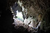
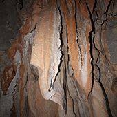
Raxruhá's most famous tourist spot is the Candelaria Caves. These are a huge system of natural caves. They are found where the lowlands meet the mountains. The caves are located between the municipalities of Chisec and Raxruhá.
The Candelaria Caves are special for two reasons. First, they are very beautiful to look at. Second, they were very important to the ancient Mayan culture. They hold a lot of history and mystery.
Candelaria caves
-
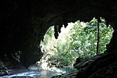
Underground Candelaria river.
-
-


Climate and Weather
What is the Climate Like in Raxruhá?
Raxruhá has a tropical climate. This means it is warm all year round. It also gets a lot of rain. This type of climate is called Af in the Köppen climate classification.
| Climate data for Raxruhá | |||||||||||||
|---|---|---|---|---|---|---|---|---|---|---|---|---|---|
| Month | Jan | Feb | Mar | Apr | May | Jun | Jul | Aug | Sep | Oct | Nov | Dec | Year |
| Mean daily maximum °C (°F) | 26.3 (79.3) |
28.4 (83.1) |
29.8 (85.6) |
31.6 (88.9) |
31.6 (88.9) |
31.8 (89.2) |
30.0 (86.0) |
30.4 (86.7) |
30.4 (86.7) |
29.6 (85.3) |
27.8 (82.0) |
26.8 (80.2) |
29.5 (85.2) |
| Daily mean °C (°F) | 22.5 (72.5) |
23.5 (74.3) |
25.1 (77.2) |
26.5 (79.7) |
27.1 (80.8) |
27.4 (81.3) |
26.2 (79.2) |
26.4 (79.5) |
26.3 (79.3) |
25.7 (78.3) |
24.0 (75.2) |
22.5 (72.5) |
25.3 (77.5) |
| Mean daily minimum °C (°F) | 18.8 (65.8) |
18.6 (65.5) |
20.5 (68.9) |
21.4 (70.5) |
22.6 (72.7) |
23.0 (73.4) |
22.5 (72.5) |
22.4 (72.3) |
22.2 (72.0) |
21.8 (71.2) |
20.3 (68.5) |
18.3 (64.9) |
21.0 (69.9) |
| Average precipitation mm (inches) | 138 (5.4) |
74 (2.9) |
79 (3.1) |
88 (3.5) |
189 (7.4) |
318 (12.5) |
335 (13.2) |
258 (10.2) |
301 (11.9) |
278 (10.9) |
203 (8.0) |
159 (6.3) |
2,420 (95.3) |
| Source: Climate-Data.org | |||||||||||||
Geographic Location
Where is Raxruhá Located?
Raxruhá is located in the Alta Verapaz Department. It is surrounded by other municipalities. To its west, north, south, and southwest is Chisec. To its east, northeast, and southeast is Fray Bartolomé de las Casas.
 |
Chisec | Chisec | Fray Bartolomé de las Casas | |
| Chisec | Fray Bartolomé de las Casas | |||
| Chisec | Chisec | Fray Bartolomé de las Casas |
See also
 In Spanish: Raxruhá para niños
