Renaud Island facts for kids

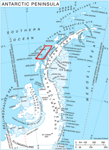
Location of Biscoe Islands in the Antarctic Peninsula region
|
|
| Geography | |
|---|---|
| Location | Antarctica |
| Coordinates | 65°40′S 66°00′W / 65.667°S 66.000°W |
| Archipelago | Biscoe Islands |
| Area | 440 km2 (170 sq mi) |
| Length | 40 km (25 mi) |
| Width | 11 km (6.8 mi) |
| Administration | |
| Administered under the Antarctic Treaty System | |
| Demographics | |
| Population | Uninhabited |
Renaud Island is a large, ice-covered island located in Antarctica. It is about 40 kilometers (25 miles) long. The island's width changes, ranging from 6 to 16 kilometers (4 to 10 miles). On average, it is about 11 kilometers (7 miles) wide.
Renaud Island is part of a group of islands called the Biscoe Islands. It lies between two other islands: the Pitt Islands to its northeast and Rabot Island to its southwest.
Where is Renaud Island?
Renaud Island is found in the Biscoe Islands. This group of islands is located off the coast of the Antarctic Peninsula. The Antarctic Peninsula is the northernmost part of the mainland of Antarctica.
The island is separated from the Pitt Islands by a waterway called Mraka Sound. To its southwest, Pendleton Strait separates it from Lavoisier Island. On the eastern side of Renaud Island, there is a bay named Zubov Bay. This bay stretches about 4 kilometers (2.5 miles) into the island's coastline.
Discovery of the Island
Renaud Island was first mapped and named by a group of explorers. This happened during the French Antarctic Expedition. The expedition took place between 1908 and 1910. It was led by a famous French explorer named Jean-Baptiste Charcot. He and his team were the first to chart this icy island.
See also
 In Spanish: Isla Renaud para niños
 | Selma Burke |
 | Pauline Powell Burns |
 | Frederick J. Brown |
 | Robert Blackburn |

