Rexford Glacier facts for kids
Quick facts for kids Rexford Glacier |
|
|---|---|

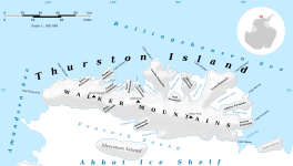
Map of Thurston Island
|
|
| Location | Ellsworth Land |
| Coordinates | 72°05′00″S 100°04′00″W / 72.08333°S 100.06667°W |
| Thickness | unknown |
| Terminus | Wagoner Inlet |
| Status | unknown |
The Rexford Glacier is a huge river of ice located in a very cold place called Antarctica. It flows towards the northeast and ends up in a bay called Wagoner Inlet. This bay is found on the northern side of Thurston Island, which is part of Ellsworth Land in Antarctica.
Contents
What is a Glacier?
A glacier is like a giant, slow-moving river made of ice. It forms over many, many years as layers of snow pile up and get pressed together. This pressure turns the snow into thick ice. Glaciers move very slowly, carving out valleys and shaping the land as they go. They are important parts of Earth's climate system.
Where is Rexford Glacier Located?
Rexford Glacier is in one of the coldest places on Earth: Antarctica. Specifically, it's on Thurston Island. This island is located off the coast of Ellsworth Land, a part of West Antarctica. The glacier's ice flows into Wagoner Inlet, which is a narrow arm of the sea.
How Rexford Glacier Got Its Name
Naming Places in Antarctica
Many places in Antarctica are named by a group called the Advisory Committee on Antarctic Names (US-ACAN). This committee is part of the United States government. Their job is to decide the official names for features like mountains, glaciers, and bays in Antarctica. They often name places after people who helped explore or study the continent.
Honoring Phillip W. Rexford
Rexford Glacier was named after a brave person named Phillip W. Rexford. He was an Aviation Radioman, which means he worked with radios on airplanes. Phillip Rexford was part of a big United States Navy trip called U.S. Navy Operation Highjump. This operation happened between 1946 and 1947.
Operation Highjump
Operation Highjump was a large expedition by the U.S. Navy to Antarctica. Its main goal was to explore and map the continent. Airplanes played a very important role in this mission. They flew over vast areas, taking many aerial photographs. These photos helped scientists and mapmakers understand what Antarctica looked like. Phillip W. Rexford was part of an aircrew that flew these missions. The pictures they took helped to map this glacier and the nearby coastlines. That's why the glacier was named in his honor!


