
Rhine–Main–Danube Canal facts for kids
Quick facts for kids Rhein-Main-Danube Canal |
|
|---|---|

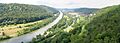
The RMD Canal from Bamberg to Kelheim
|
|
| Specifications | |
| Length | 171 km (106 mi) |
| Maximum boat length | 190 m (623 ft) |
| Maximum boat beam | 11.45 m (38 ft) |
| Locks | 16 |
| Maximum height above sea level | 406 metres (1,332 ft) |
| Total rise | North: 175 metres (574 ft); South: 68 metres (223 ft) |
| Navigation authority | Federal Waterways and Shipping Administration |
| History | |
| Date completed | 1992 |
| Geography | |
| Start point | Main at Bamberg, Germany |
| End point | Danube at Kelheim, Germany |


The Rhine–Main–Danube Canal (also called Main-Danube Canal or Europa Canal) is a man-made waterway in Bavaria, Germany. It connects two major rivers, the Main and the Danube. This canal helps ships travel across the European Watershed, which is like a natural dividing line for water flowing into different oceans.
The canal starts in Bamberg, goes through Nuremberg, and ends in Kelheim. It creates a shipping route that links the North Sea and the Atlantic Ocean to the Black Sea. This means boats can travel all the way from the Rhine river in the Netherlands to the Danube Delta in Romania and Ukraine. The canal we see today was finished in 1992 and is 171 kilometres (106 mi) long.
Contents
Building a Waterway: A Long History
People have wanted to connect the Danube and Rhine rivers for a very long time. It's a dream that goes back centuries!
Early Attempts to Connect Rivers
Back in 793, a famous emperor named Charlemagne ordered the building of a canal called the Fossa Carolina. This early canal tried to link the Swabian Rezat (a small river) to the Altmühl river.
Much later, between 1836 and 1846, another canal was built. It was named the Ludwig Canal after King Ludwig I of Bavaria. This canal connected Bamberg and Kelheim, just like the modern one. However, it had problems. It was too narrow, had too many locks, and sometimes didn't have enough water. Because of these issues, and because railways were becoming popular, the Ludwig Canal soon became too expensive to use. It was finally closed in 1950 after being damaged during World War II.
Planning the Modern Canal
In 1917, the government of Bavaria decided to build a much bigger shipping route. This new route would be able to handle large ships, up to 1,200 tons, like those used on the Rhine.
Then, in 1921, Bavaria and the German government made an agreement to build the "Main-Donau-Wasserstraße" (Main-Danube Waterway). A company called Rhein-Main-Donau AG (RMD-AG) was created to manage this huge project. To pay for it, the company was given control over water resources from several rivers.
How the Canal Was Built
The first detailed plans for the new canal appeared in 1938. Some early work even started in 1939. However, these plans changed after World War II.
Getting Started and Finishing Up
By 1962, the Main river had been made wider and deeper all the way to Bamberg. In 1966, an important agreement called the Duisburger Vertrag was signed. This agreement between Bavaria and the German government helped pay for the rest of the canal.
The last part of the canal, between Nuremberg and Kelheim, caused some debate in the 1970s and 1980s. This was mainly because a 34-kilometre (21 mi) section went through the beautiful Altmühl valley. Despite the discussions, the canal was finally finished on September 25, 1992. Building it cost a lot of money, about 2.3 billion euros. But almost 20% of that money was spent on projects to protect the environment!
The Canal's Path
The Rhine–Main–Danube Canal follows a winding path through Germany.
Following River Valleys
From Bamberg to Fürth, the canal travels along the valley of the Regnitz river. The Regnitz is a smaller river that flows into the Main.
After Fürth, the canal follows the valley of the Rednitz river, which is another branch of the Regnitz. It continues past Roth.
Crossing the Mountains
Next, the canal crosses the Franconian Jura mountains. This is a big engineering challenge! It then connects with the Altmühl river near Dietfurt. From Dietfurt to Kelheim on the Danube, the canal continues to follow the Altmühl valley.
Old Canal Remnants
Did you know parts of the old Ludwig Canal still exist? Between Nuremberg and Berching, about 60 km of the old canal are still in good shape. Some of its old locks can even still work! Part of the path next to the old canal has been turned into a bike track, which is a fun way to explore history. The old canal gets very close to the new one at Pollanten, and they even run side-by-side for a bit before meeting south of Berching.
How Big is the Canal?
The Rhine–Main–Danube Canal is designed to handle large ships.

Canal Shape and Size
Most of the canal is shaped like a trapezoid. This means it's wider at the top than at the bottom. It's about 31 metres (102 ft) wide at the bottom and 55 metres (180 ft) wide at the water surface. The water is about 4 metres (13 ft) deep.
The canal is a "Waterway Class Vb," which means it can handle very large boats. The biggest ships allowed are 190 metres (620 ft) long and 11.45 metres (37.6 ft) wide.
Highest Point on the Water
The total length of the canal is 171 kilometres (106 mi). The highest point on the canal is between the Hilpoltstein and Bachhausen locks. This spot is 406 metres (1,332 ft) above sea level. This is actually the highest point on Earth that commercial ships can reach from the sea!
To get from the Main river at Bamberg up to this highest point, ships have to be lifted 175 metres (574 ft) through 11 locks. Then, to go down to the Altmühl river at Dietfurt, they drop 51 metres (167 ft) through three more locks. The total drop to the Danube is 68 metres (223 ft). This means the Danube end of the canal is 107.3 metres (352 ft) higher than the Main end!
How Locks Work
Along the canal, there are 16 locks. These are like water elevators that lift or lower ships from one water level to another. Some of these locks can lift ships as high as 25 meters (about 81 feet)!
Managing the Locks
All 16 locks are controlled from just four special centers. These centers have a few workers who manage the locks day and night. The locks were updated between 2001 and 2007 with modern computer systems to make them work better.
Saving Water
Thirteen of the locks are designed to save water. When a ship goes down, the lock doesn't just let all the water out. Instead, it pipes some of the water into special side tanks. Then, when a ship needs to go up, this stored water is used to help fill the lock again. This clever system helps save a lot of water!
| Lock name | Year in
use |
Channel
kilometres |
Distance
(km) |
Height above
sea level (m) |
Drop of
lock (m) |
|
|---|---|---|---|---|---|---|
| 1 | Bamberg | 1966 | 7.42 | 5.87 | 241.80 | 10.94 |
| 2 | Strullendorf | 1967 | 13.29 | 12.60 | 249.21 | 7.41 |
| 3 | Forchheim | 1964 | 25.89 | 6.97 | 254.50 | 5.29 |
| 4 | Hausen | 1968 | 32.86 | 8.19 | 266.50 | 12.00 |
| 5 | Erlangen | 1970 | 41.05 | 7.61 | 284.80 | 18.30 |
| 6 | Kriegenbrunn | 1970 | 48.66 | 20.43 | 303.10 | 18.30 |
| 7 | Nuremberg | 1971 | 69.09 | 3.73 | 312.50 | 9.40 |
| 8 | Eibach | 1978 | 72.82 | 11.50 | 331.99 | 19.49 |
| 9 | Leerstetten | 1980 | 84.32 | 10.62 | 356.66 | 24.67 |
| 10 | Eckersmuhlen | 1985 | 94.94 | 4.05 | 381.33 | 24.67 |
| 11 | Hilpoltstein | 1989 | 98.99 | 16.47 | 406.00 | 24.67 |
| 12 | Bachhausen | 1989 | 115.46 | 16.47 | 406.00 | 17.00 |
| 13 | Berching | 1991 | 122.51 | 7.05 | 389.00 | 17.00 |
| 14 | Dietfurt | 1984 | 135.26 | 12.75 | 372.00 | 17.00 |
| 15 | Riedenburg | 1982 | 150.83 | 15.57 | 355.00 | 8.40 |
| 16 | Kelheim | 1981 | 166.06 | 15.23 | 346.60 | 8.40 |
What the Canal is Used For
The Rhine–Main–Danube Canal is very important for moving goods. In 2004, about 6.9 million tons of goods were transported on the canal. This includes things like food, metals, building materials, and fertilizers.
Using the canal for shipping helps reduce the number of trucks on roads. It's estimated that the canal carries traffic that would otherwise need 250,000 truck trips every year! This is much better for the environment.
The canal also brings in money from tourism. Many people enjoy boat trips and activities along the canal.
Impact on Nature
Building a canal can affect the environment. The Main-Danube Canal allows animals to move between Western and Eastern Europe.
New Species Moving In
Sometimes, new animals arrive in an area where they didn't live before. These are called invasive species. They can sometimes cause problems for the animals already living there, like competing for food. But sometimes, they can also fit in and add to the local wildlife.
About 20 types of small water animals and several kinds of fish have spread from the Danube to the Main and then to the Rhine. Some examples of fish that have moved are the Topmouth gudgeon and the Asp.
Animals can also move the other way, from west to east. For example, the Asian clam and the Chinese mitten crab have been found in the Danube.
To keep water levels high enough for ships, water is sometimes moved from the Altmühl river to reservoirs. This water then helps fill the canal.
The 1979 Dam Incident

During the canal's construction, there was a serious accident on March 26, 1979. A dam broke in the Katzwang area near Nuremberg. This part of the canal was still being built but already had water in it.
A huge amount of water, about 350,000 cubic metres (12,000,000 cu ft), rushed out through a 15-metre (49 ft) wide hole. The water flooded many parts of old Katzwang. The force of the water was so strong that it created a 10-metre (33 ft) wide crater and swept away cars and even damaged houses. Sadly, a 12-year-old girl died during the rescue efforts. The damage from this event was very expensive. After this, the entire canal was carefully checked for any weak spots and made stronger where needed.
Triathlon Event
Every July, a big sports event called the Challenge Roth triathlon takes place. It includes a 3.8-kilometre (2.4 mi) swim in the Main-Danube Canal near Hilpoltstein. During the race, the canal is closed to all ship traffic to keep the athletes safe. Also, about 14-kilometre (8.7 mi) of the running part of the triathlon follows the canal, from the Hilpoltstein lock to the Leerstetten lock.
Images for kids
-
Altmühl below Riedenburg
See also
 In Spanish: Canal Rin-Meno-Danubio para niños
