Rhynie, South Australia facts for kids
Quick facts for kids RhynieSouth Australia |
|
|---|---|

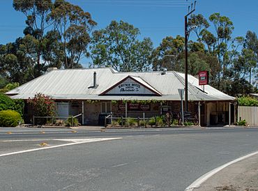
Rhynie Hotel established 1860
|
|
| Established | 1859 |
| Postcode(s) | 5412 |
| LGA(s) | District Council of Clare and Gilbert Valleys |
| Region | Mid North |
| State electorate(s) | Frome |
| Federal Division(s) | Grey |
Rhynie is a small, quiet town in South Australia. It sits right in the middle of two other towns, Tarlee and Auburn. You can find Rhynie along the Horrocks Highway, a main road in the area.
Contents
Discover Rhynie: A Small South Australian Town
Rhynie was officially planned and started in the year 1859. This means people decided where the streets and buildings would go, and then the town began to grow.
How Rhynie Started
When Rhynie was first set up in 1859, it was a new place for people to live and work. Towns like Rhynie often grew because of farming or new roads being built.
Travel and Trails
For many years, Rhynie had its own railway line called the Spalding railway line. This line helped people and goods travel to and from the town. However, the railway closed down in April 1984.
After the railway closed, the tracks were removed. But the path wasn't wasted! It was turned into a fun place for people to enjoy. Now, it's called the Rattler Rail Trail, a special path for cycling and walking. It's a great way to explore the area around Rhynie.
Who Governs Rhynie?
Rhynie is part of a larger local government area. This area is called the District Council of Clare and Gilbert Valleys. A local council helps manage things like roads, parks, and community services for the people living in the town and nearby areas.
Famous Faces from Rhynie
Even small towns can be home to important people! A well-known missionary named Annie Lock was born in Rhynie. Missionaries are people who travel to different places to help others and share their beliefs.
 | Kyle Baker |
 | Joseph Yoakum |
 | Laura Wheeler Waring |
 | Henry Ossawa Tanner |


