
Richland, Texas facts for kids
Quick facts for kids
Richland, Texas
|
|
|---|---|
|
Town
|
|
.jpg)
First Baptist Church
|
|

Location of Richland, Texas
|
|
 |
|
| Country | United States |
| State | Texas |
| County | Navarro |
| Area | |
| • Total | 1.52 sq mi (3.93 km2) |
| • Land | 1.51 sq mi (3.91 km2) |
| • Water | 0.01 sq mi (0.03 km2) |
| Elevation | 367 ft (112 m) |
| Population
(2010)
|
|
| • Total | 255 |
| • Density | 167.8/sq mi (64.89/km2) |
| Time zone | UTC-6 (Central (CST)) |
| • Summer (DST) | UTC-5 (CDT) |
| ZIP code |
76681
|
| Area code(s) | 903 |
| FIPS code | 48-61820 |
| GNIS feature ID | 2412548 |
| Historical population | |||
|---|---|---|---|
| Census | Pop. | %± | |
| 1930 | 541 | — | |
| 1940 | 369 | −31.8% | |
| 1950 | 308 | −16.5% | |
| 1960 | 287 | −6.8% | |
| 1970 | 309 | 7.7% | |
| 1980 | 260 | −15.9% | |
| 1990 | 244 | −6.2% | |
| 2000 | 291 | 19.3% | |
| 2010 | 264 | −9.3% | |
| 2020 | 255 | −3.4% | |
| U.S. Decennial Census 2020 Census |
|||
Richland is a small town located in Navarro County, Texas, in the United States. In 2020, about 255 people lived there. It's a quiet place with a rich history.
Contents
About Richland's Location
Richland is found in south-central Navarro County, Texas. It covers a total area of about 1.1 square miles (2.8 square kilometers). All of this area is land.
Richland's Past: A Look at Its History
-
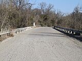
Love's Bridge at Richland Creek Crossing Near Richland Texas.
-
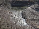
Richland Crossing Navarro County Texas from Love's Bridge, Love's Bridge Road. This low water crossing was used by early Navarro County settlers.


Richland is located where Interstate 45 and State Highway 14 meet. It sits on a place called Pisgah Ridge. The town is about twelve miles south of Corsicana.
Early Days and Growth
The area was first settled in the late 1840s. By 1848, a man named Asa Chambers had opened a store. This store was on the main trail from Corsicana to Franklin. A post office, named Richland Crossing, opened in his store. It was named after the nearby Richland Creek.
The store moved and changed owners several times. It remained the center of the community until the early 1870s. In 1871, the Houston and Texas Central Railway built tracks through the area. A train station was built near the store on Pisgah Ridge. This station was named Richland. A new community began to grow around this train depot.
Life in the Late 1800s
A new post office, also named Richland, started in 1878. By the mid-1890s, Richland was a busy town. It had two steam gristmills and cotton gins. These machines helped process crops. There were also three general stores, a grocer, and two blacksmiths. The town had two saloons, a hardware store, and a bank. About 150 people lived there.
The first school in Richland opened around the time of the Civil War. By 1906, the town had a school with two teachers. About 75 students attended this school.
Changes Over Time
Richland continued to grow in the 1920s. Its population reached its highest point of 750 people in 1929. However, during the 1930s, the population started to shrink. This was partly because of the Great Depression, a time when many people faced economic hardship.
By 1950, Richland had 12 businesses and 369 residents. The population continued to decline in the 1960s and 1970s. By 1990, only 244 people lived in Richland, and there was only one business left. In 2000, the population increased slightly to 291 people.
Richland's Population Today
In 2000, there were 291 people living in Richland. These people lived in 126 households. About 79 of these households were families. The town's population was spread out across different age groups.
About 19.9% of the people were under 18 years old. Around 11.3% were between 18 and 24 years old. People aged 25 to 44 made up 24.1% of the population. Those between 45 and 64 years old were 27.1%. Finally, 17.5% of the population was 65 years or older. The average age in Richland was 41 years.
Education in Richland
The students in Richland attend schools that are part of the Corsicana Independent School District. This district provides public education for the town's children and teens.
See also
 In Spanish: Richland (Texas) para niños
