Rima River facts for kids
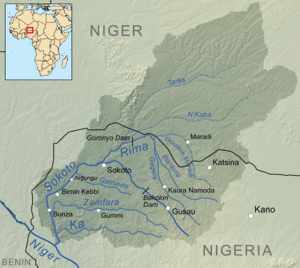
The Rima River is an important river located in the northern part of Nigeria. It flows through different areas before joining other rivers.
Contents
About the Rima River
The Rima River starts its journey in northern Nigeria. It is known for its changing flow throughout the year. During the rainy season, the river flows strongly. However, in the dry season, parts of the upper Rima River can become very shallow or even dry up. This makes it a seasonal river.
Where Does the Rima River Flow?
The Rima River has a specific path it follows. A smaller river called the Goulbi de Maradi River flows near the Rima River's northernmost point. The Rima River then travels southwest. It eventually meets and joins the Sokoto River close to the city of Sokoto. After this meeting, the combined rivers continue flowing south. Their journey ends when they empty into the mighty Niger River, one of Africa's longest rivers.
Water for Farms: The Zauro Polder Project
The Rima River is very important for farming in the region. For many years, there have been plans for a big project called the Zauro polder project. This project aims to help farmers by providing water for their crops.
What is a Polder Project?
A polder project involves building walls or dams to control water levels in an area. This helps to create land that can be used for farming, especially in areas that might flood. The Zauro polder project is designed to bring water to a large area of farmland.
How Much Land Will It Help?
The Zauro polder project is planned to supply water to about 10,572 hectares (which is about 26,124 acres) of farmland. This land is located in the Rima River's floodplain, which is the flat land next to the river that can sometimes get flooded. This specific area is between the towns of Argungu and Birnin Kebbi. By providing steady water, the project aims to help farmers grow more food and improve their lives.
See also
 In Spanish: Río Rima para niños
 | Emma Amos |
 | Edward Mitchell Bannister |
 | Larry D. Alexander |
 | Ernie Barnes |


