
Rincón de Tres Cerros facts for kids

Rincón de Tres Cerros is a special area in the Rivera Department of Uruguay. Its name means "corner of the three hills." It's located between the Tacuarembó River and a stream called Arroyo Cuñapirú. This is why it's called a "corner." This place is famous for its three flat-topped hills, or cerros, that stand out on the horizon. They are lined up from the biggest in the south to the smallest in the north.
Contents
The Three Hills of Rincón
The three main hills are very important to this area. They are like natural landmarks.
Cerro Zapato: The Biggest Hill
The largest hill is called "Cerro Zapato" or "Alpargata." Both names mean "shoe" because of its unique shape when you look at it from above. It's the biggest of the three.
Cerro del Medio: The Middle Hill
Next is "Cerro del Medio," which simply means "hill of the middle." It stands between the biggest and smallest hills.
Cerro Chapeu: The Smallest Hill
The smallest hill is named "Cerro Chapeu." "Chapeu" means "hat" in Portuguese.
Nature Around the Hills
Most of these hills are bare, meaning they don't have many trees. However, you can find some native woodland trees growing around the edges of their flat tops. Cerro Zapato also has some Eucalyptus trees. These trees were planted along its northeastern side and on part of its top surface.
Getting to Rincón de Tres Cerros
Sometimes, it can be hard to get to Rincón de Tres Cerros because of flooding. The main bridges that lead into the area can get cut off. This happens at Paso Rogelio over the Tacuarembó Grande river, at Paso Cunha over the Arroyo Cuñapirú stream, and at El Sauce over another part of the Tacuarembó Grande river.
However, this flooding has become much less common recently. Many Eucalyptus and Pine forests have been planted, especially near the Tacuarembó river. These new forests help to soak up water, which reduces the floods.
Life in the Area
Today, there is one rural public school in Rincón de Tres Cerros. It's called school number 87 and is located on the northern side of the biggest hill.
In the past, there were more schools. There used to be three schools in total. One of them, located along the road from Corrales, closed in the 1980s. Another school at Paso Cunha closed in the early 1990s. These schools closed because fewer people lived in the area. This movement of people away from rural areas is sometimes called "rural flight."
In the 1900s, many more people lived in Rincón de Tres Cerros than today. There used to be a shop, a bar, and even a hairdresser's near Cerro Alpargata. There was also another shop and bar at Paso Cunha.
Geo coordinates
- Cerro Zapato 31°37′46″S 55°37′0″W / 31.62944°S 55.61667°W
- Cerro del Medio 31°35′20″S 55°37′38″W / 31.58889°S 55.62722°W
- Cerro Chapeu 31°34′1″S 55°38′10″W / 31.56694°S 55.63611°W
Images for kids
-
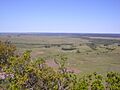
Southeast view from Cerro Zapato
-
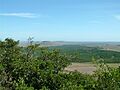
Northwest view from Cerro Zapato


See also
 In Spanish: Rincón de Tres Cerros para niños
