
Rivera Department facts for kids
Quick facts for kids
Rivera
|
|||
|---|---|---|---|

View of Rivera from Cerro Marconi.
|
|||
|
|||

Location of Rivera, in red, in Uruguay
|
|||
| Country | |||
| Creation | 1884 | ||
| Capital | Rivera | ||
| Area | |||
| • Total | 9,370 km2 (3,620 sq mi) | ||
| Population
(2011)
|
|||
| • Total | 103,493 | ||
| • Density | 11.045/km2 (28.607/sq mi) | ||
| Time zone | UTC-03 (UYT) | ||
| ISO 3166 code | UY-RV | ||
| Website | Official website: http://www.rivera.gub.uy | ||


The Rivera department (which means Departamento de Rivera in Spanish) is one of the regions, or departments, that make up Uruguay. Its main city and capital is the city of Rivera.
The special code for Rivera department, used for international standards, is UY-RV.
Contents
What's in a Name?
The Rivera department and its capital city are named after an important person in Uruguay's history. This person was Fructuoso Rivera (1784–1854). He was the very first president of Uruguay.
Exploring Rivera's Geography

The Rivera department is located in the northern part of Uruguay. It covers an area of about 9,370 square kilometers (3,618 square miles). This makes it the 11th largest department in the country.
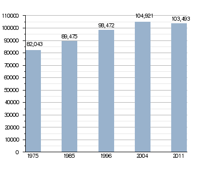
Rivera is home to many people. It is the eighth most populated department in Uruguay. In 2011, about 103,493 people lived there. This means there were about 11 people living in each square kilometer.
Hills and Mountains
Rivera has three main groups of low, rounded hills. These are called cuchillas in Uruguay.
- The Cuchilla de Haedo is in the northwest. It is one of the most important cuchillas in the country.
- The Cuchilla Negra comes from the north and meets the Cuchilla de Haedo.
- Between these two cuchillas is the Cerro de los Peludos hill.
- The Cuchilla de Santa Ana runs along the border with Brazil to the north.
In the middle of the department, you can find the Cerro de la Cruz hill. Towards the east, there are the Cerro del Hospital and Cerro Bonito hills.
Where is Rivera Located?
The Rivera department shares its borders with several other places:
- To the north: It borders Brazil.
- To the east: It borders Brazil and the Cerro Largo department. The Río Negro river separates it from Cerro Largo.
- To the south: It borders the Tacuarembó department. The Río Tacuarembó river forms this border.
- To the west: It borders the Tacuarembó and Salto departments.
 |
Salto | Brazil | Brazil | |
| Tacuarembó | Brazil | |||
| Tacuarembó | Tacuarembó | Cerro Largo |
Rivers Flowing Through Rivera
The Río Negro river flows along the eastern border of the department. Many smaller rivers and streams that feed into the Río Negro flow through the eastern part of Rivera.
The Tacuarembó river forms part of the southern border. This river is a tributary of the Río Negro. Many other rivers and streams that feed into the Tacuarembó river flow through most of the department.
Rivera's Climate
The climate in Rivera is known as a "Humid subtropical climate" (type Cfa). This means it has warm, humid summers and mild winters.
Rivera gets a lot of rain throughout the year. The average rainfall is about 1,638.3 millimeters (64.5 inches) per year.
- The rainiest month is usually October, with about 162.6 mm (6.4 inches) of rain.
- The driest month is typically June, with about 101.6 mm (4.0 inches) of rain.
The average temperature in Rivera for the whole year is 16.7°C (62.1°F).
- January is usually the warmest month, with an average temperature of 23.9°C (75.0°F).
- June is typically the coolest month, with an average temperature of 10.6°C (51.1°F).
Who Lives in Rivera?
People who live in the Rivera department, and especially in the city of Rivera, are called Riverenses in Spanish.
How Rivera's Population Has Grown
People Living in Rural Areas

The 2011 census showed that about 7,602 people in Rivera live in rural areas. These are places outside of big towns and cities.
Main Towns and Cities
Here are some of the biggest towns and cities in the Rivera department, based on the 2011 census:
| City / Town | Population (2011) |
|---|---|
| Rivera | 64,485 |
| Tranqueras | 7,235 |
| Mandubí | 6,019 |
| Minas de Corrales | 3,788 |
| Vichadero | 3,698 |
| La Pedrera | 3,363 |
| Santa Teresa | 2,657 |
| Lagunón | 2,376 |
Images for kids
-
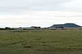
Rincón de Tres Cerros is a beautiful natural area.
-
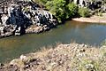
Valle del Lunarejo is a valley known for its unique landscape.


Related Information
See also
 In Spanish: Departamento de Rivera para niños
