Hondo River (Belize) facts for kids
- This article is about the river in Belize and Mexico; for other uses, see Rio Hondo
Quick facts for kids Hondo River |
|
|---|---|

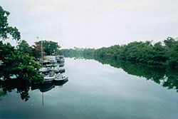
The Rio Hondo, border between Mexico and Belize
|
|
| Country | Belize, Mexico |
| Physical characteristics | |
| Main source | Belize |
| River mouth | Chetumal Bay 0 m (0 ft) 18°29′16″N 88°19′06″W / 18.48791°N 88.31841°W |
| Length | 150 km (93 mi) |
| Basin features | |
| Basin size | 2,688.54 km2 (1,038.05 sq mi) |
The Rio Hondo is an important river in Central America. It is about 150 kilometers (93 miles) long. The river flows towards the northeast and empties into Chetumal Bay, which is part of the Caribbean Sea. For most of its length, the Rio Hondo forms the natural border between the countries of Mexico and Belize.
Contents
Where the Rio Hondo Flows
The Rio Hondo starts in Belize and flows generally northeast. It travels through flat lands before reaching the sea. The river's path helps define the boundary between two countries. This makes it a significant geographical feature.
History and Culture Along the River
Many ancient archaeological sites are found near the Rio Hondo. These sites belong to the Maya civilization. The Maya were an amazing ancient people who lived in this area long before Europeans arrived. They built large cities and developed advanced writing and math systems. The river was likely a key pathway for trade and travel for them.
The Rio Hondo in Belize's National Anthem
The Rio Hondo is so important to Belize that it is even mentioned in the country's national anthem. The anthem is called Land of the Free. One part of the song talks about the river, showing its special place in the country's history and identity. This highlights how the river is a symbol of Belize's natural beauty and its borders.
See also
 In Spanish: Río Hondo para niños

