
River Bourne, Dorset facts for kids
Quick facts for kids River Bourne |
|
|---|---|

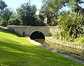
The River Bourne as it flows through Bournemouth Gardens
|
|

Location within Dorset
|
|
| Country | United Kingdom |
| County | Dorset |
| Physical characteristics | |
| Main source | Dorset |
| River mouth | Bournemouth, Dorset 50°42′58″N 1°52′26″W / 50.716°N 1.874°W |
The River Bourne is a small river in Dorset, England. It flows into the English Channel at Bournemouth. The river's name comes from an old English word, bourn or burn, which simply means a small stream. The town of Bournemouth was named after this very river!
Contents
The River Bourne's Journey
The River Bourne is made up of two main streams. Together, they flow for just over 13 kilometers (about 8 miles). A big part of this journey, about 5.7 kilometers (3.5 miles), happens underground in tunnels called culverts. The rest, about 7.5 kilometers (4.6 miles), flows in the open air.
Where Does the River Start?
The exact starting points of the River Bourne are a bit of a mystery! We know it gets its water from several places. The very beginning of the stream comes from three underground tunnels. People think one of these tunnels drains water from Canford Heath. Another might get water from the Bournemouth and West Hampshire Water works. The third tunnel probably collects water that runs off roads.
After flowing across Alderney Recreation Ground, the stream goes underground again for about 2.4 kilometers (1.5 miles). It then pops back out into the open at Coy Pond Gardens. The river also gets water from natural wet spots in the ground, called seeps. There are also 62 places where surface water drains into the river.
The River's Path and Slope
The area where the River Bourne collects its water is called its catchment. In the upper parts of the river, this area is roughly bordered by Ringwood Road, Wallisdown Road, and Ashley Road/Poole Road. As the river gets closer to the sea, its catchment area gets narrower.
From its highest points to where it meets Poole Bay, the river drops about 60 meters (nearly 200 feet). This means the river flows downhill quite steeply, which makes the water move faster!
Flowing Through Bournemouth
As the River Bourne reaches Bournemouth, it flows through beautiful public areas known as the Upper, Central, and Lower Gardens. This is a lovely part of its journey where you can see it clearly.
However, when it reaches The Square (which divides the Central and Lower Gardens), the river goes underground again. It also disappears just before it reaches the beach, right next to Bournemouth Pier. So, you can't actually see where the river meets the sea!
Images for kids
-
The River Bourne as it flows through Bournemouth Gardens
