Poole Bay facts for kids
Quick facts for kids Poole Bay |
|
|---|---|
 |
|
| Coordinates | 50°40′N 1°52′W / 50.667°N 1.867°W |
| Ocean/sea sources | English Chanel, Atlantic Ocean |
| Max. length | 16 km (9.9 mi) |
| Settlements | Poole, Bournemouth |
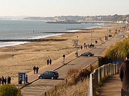
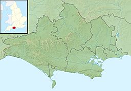
Poole Bay is a large bay located on the coast of Dorset in southern England. It's part of the English Channel, which is connected to the Atlantic Ocean. The bay stretches for about 16 kilometers (10 miles). It goes from Sandbanks near Poole Harbour in the west to Hengistbury Head in the east.
Poole Bay is a fairly shallow area of water that curves inward from the main coastline. It has steep cliffs made of sandstone and several 'chines'. Chines are natural gaps in the cliffs that make it easy to get down to the sandy beaches below. The coast along the bay is very developed with many buildings. It's part of a big urban area that includes parts of the towns of Poole, Bournemouth, and Christchurch. Many people also call it Bournemouth Bay because a large part of it is next to Bournemouth.
This bay has the longest continuous stretch of sand on England's south coast. While there are more sandy areas to the west across many smaller bays, Poole Bay's sandy stretch is longer than other famous ones to the east, like Avon Beach, West Wittering, and Camber Sands.
Protecting Poole Bay's Beaches
Over the years, people have taken steps to stop the coast from wearing away, a process called coastal erosion. Throughout the 20th century, concrete seawalls and structures called groynes were built. Groynes are low walls or barriers that stick out into the water from the beach. They help to trap sand and prevent it from being washed away by the sea.
These structures allowed homes and roads to be built safely on top of the cliffs. However, they also stopped the natural supply of sand and gravel from reaching the shore. To fix this, sand has been added back to the beaches. From 1970 to 2000, over 1.5 million cubic meters of sand were used to rebuild the beaches at Bournemouth and Poole.
More sand was added during the winters of 2005 and 2006. This time, 1.1 million cubic meters of sand came from Poole Harbour. Another 700,000 cubic meters were brought from a special area off the Isle of Wight.
In 2015, a big project was approved to protect the beaches for the next 100 years. This project will cost £43.7 million and last 17 years. The plans include replacing old groynes and building new ones. They also involve adding 210,000 cubic meters of sand and gravel to the beaches every three years. This helps keep the beaches wide and sandy for everyone to enjoy.
How Poole Bay Was Formed
The area of Poole Bay was mainly formed during the Pleistocene period. This was a time in Earth's history that started about 2.6 million years ago and ended about 11,700 years ago. During this period, a large river called the Solent river flowed across what is now South East Dorset and West Hampshire. It even flowed past the Isle of Wight.
The cliffs and the seabed under Poole Bay are made of rocks from the Tertiary period. These rocks belong to a group called the Bracklesham Group. They are made up of different types of sand, from very fine to coarse.
At Hengistbury Head, you can find slightly younger rocks from the Bartonian group. These rocks include layers of sand and clay. They also have special bands of ironstone nodules. These are hard, round lumps of rock that contain iron. These rock layers tilt towards the east. They are also cut off by a fault line that runs from the northwest to the southeast. This fault line marks the eastern edge of Christchurch Ledge, which is a continuation of the strong ironstone rocks seen at Hengistbury Head, but out in the sea.
See also
 In Spanish: Bahía de Poole para niños
 | William L. Dawson |
 | W. E. B. Du Bois |
 | Harry Belafonte |


