
Poole Harbour facts for kids
Quick facts for kids Poole Harbour |
|
|---|---|

Aerial view of the harbour entrance, looking west-north-west. The large island just inside the entrance is Brownsea Island; to its left are Furzey Island and then Green Island.
|
|

Location in Dorset
|
|
| Location | Dorset, England |
| Coordinates | 50°41′45″N 1°59′19″W / 50.69583°N 1.98861°W |
| Elevation | 0 m |
|
Designations
|
|
| Official name: Poole Harbour | |
| Designated: | 22 July 1999 |
|---|---|
| Reference #: | 1005 |
Poole Harbour is a huge natural harbour in Dorset, England. The town of Poole sits right on its edge. It's like a 'drowned valley' (called a ria) that formed when the last ice age ended. Several rivers flow into it, with the River Frome being the biggest. People have lived around this harbour for a very long time, even before the Romans arrived!
It's quite shallow, only about 48 cm (19 inches) deep on average. There's one main channel that has been dug deeper for boats, going from the harbour's entrance all the way to Holes Bay. Poole Harbour covers about 36 square kilometres (14 square miles). It's one of the places that claims to be the "second largest natural harbour in the world," after Port Jackson in Sydney, Australia. Other big harbours include Halifax Harbour in Canada and Cork Harbour in Ireland.
Contents
A Look Back in Time

In 1964, while digging in the harbour, workers found a 2,000-year-old Iron Age logboat near Brownsea Island. This boat, called the Poole Logboat, is about 10 metres (33 feet) long and is one of the largest ancient boats found in Britain. It was built around 295 BC. Because it sat very low in the water, it was probably only used inside Poole Harbour.
The Romans used Poole as a port when they invaded southern England. They set up a settlement at Hamworthy, which is now part of Poole. A Roman Road went north from Hamworthy to Badbury Rings. When the Normans took over England, Poole was just a small fishing village.
The port grew, and by 1433, Poole became a special port for exporting wool. In the Middle Ages, Poole traded with places from the Baltic Sea to Italy. In the 1600s, the town started trading with North America, especially Newfoundland. This made the town very rich. By the 1700s, Poole was the main British port trading with North America.
At the start of the 1800s, 90% of the jobs in Poole depended on the harbour. But this changed to only 20% later in the century. This happened because railways came to town, and larger ships started using Southampton, which had a deeper harbour and was closer to London. However, by regularly digging out the channel, Poole Harbour has become important again.
The longest ship to ever enter the harbour was the 186.5-metre (612-foot) Norman Voyager in 2013.
Exploring the Harbour's Geography

The entrance to Poole Harbour is from the east, coming from Poole Bay and the English Channel. As you enter, you'll see Studland beach to the south-west and Sandbanks (a peninsula with the Haven Hotel) to the north-east. Straight ahead are several islands, with Brownsea Island being the largest.
Four rivers flow into Poole Harbour. The biggest is the River Frome, which comes from the west through Dorchester and Wareham. The other rivers are the River Piddle, the Corfe River, and the Sherford River.

Moving around the harbour in a counter-clockwise direction, you'll pass the towns of Poole, including Lilliput and Parkstone. About 4 miles (6.4 km) north-west of the harbour entrance is the way into Poole Quay and Holes Bay. West of Poole is Hamworthy. Continuing counter-clockwise, you'll find the towns of Upton and Wareham, as well as where the River Piddle flows in. This part of the harbour is called Wareham Channel and includes places like Rockley Sands.
Further counter-clockwise, heading south, you'll see most of the harbour's islands and many small channels. To the west is Arne Bay and the Wych channel. Much of the land here is heathland, with fewer towns than the eastern part of the harbour. Directly south are Long Island, Round Island, and Ower Bay. Green Island, Furzey Island, and Brownsea Island are to the east. Newton Bay and Brands Bay (where there are oil wells) are to the south. This area is known as the South Deep. Continuing around brings you back to the harbour entrance and Poole Bay, with Studland beach nearby.
Lytchett Bay is to the north of the harbour and connects to it through a narrow channel near Hamworthy. The Sherford River flows into Lytchett Bay.
Holes Bay: A Quiet Corner
Holes Bay is a tidal lake north of Poole Harbour. It's a special quiet area for the harbour. The entrance to the bay is a small inlet from the main harbour. Two bridges cross this inlet: Poole Bridge and the new Twin Sails Bridge. The Twin Sails Bridge opened in 2012 and cost about £37 million. Boats taller than 2.1 metres (7 feet) can only enter Holes Bay when the bridges are lifted. This happens at set times each day and sometimes by request. The new bridge helps reduce traffic jams by making sure at least one bridge is open for cars at all times.
Pergins Island is inside Holes Bay. The South Western railway line crosses the bay on a raised path called a causeway. To the north of the bay is Upton Country Park.
Holes Bay is also where the Royal National Lifeboat Institution (RNLI) has its training school, next to its Poole headquarters. People use the bay for fishing, kayaking, and small boats. A large marina called Cobbs Quay is on the west side of the bay. On its east side, the bay runs next to the A350 road.
Parkstone Bay
Parkstone Bay is named after the area of Parkstone. Harbourside Park is located around this bay.
Islands of Poole Harbour

Poole Harbour has many islands of different sizes. These include:
- Brownsea Island: Close to the sea entrance at Sandbanks.
- Furzey Island: South of Brownsea Island.
- Green Island: Directly south of Furzey Island.
- Long Island: Near the Arne Peninsula.
- Round Island
- Gigger's Island: In the west of the Harbour near the River Piddle.
- Drove Island: In the south of the Harbour in Brands Bay.
- Pergins Island: In the north of the Harbour in Holes Bay.
- Stone Island: This is a ridge of gravel and sand between Brownsea and Studland. It's only visible at low tide and can be dangerous for sailors. It's slowly being covered by rising sea levels.
How the Harbour Was Formed

The harbour sits on soft gravel and clay that is easily worn away by rivers and the sea. This soft area is surrounded by two bands of hard chalk: the Purbeck Hills and Isle of Wight to the south, and the Dorset Downs and South Downs to the north. The clay stretched west up the Frome valley to Dorchester and originally went east beyond Portsmouth.
Before the last ice age, the River Frome flowed east through what is now the Solent. It joined other rivers like the Stour, Beaulieu, Test, Itchen, and Hamble. All these rivers then flowed into the English Channel east of the present-day Isle of Wight. A strong chalk ridge connected the Purbeck Hills to the Isle of Wight, which the rivers couldn't break through.
When the glaciers in northern Great Britain melted, southern England slowly sank. This caused the Solent valley and Southampton Water to flood, creating their special 'drowned valley' shapes. About 7,000 years ago, more erosion from the sea and stronger river flows (due to climate change) broke through the chalk hills. This separated the Isle of Wight from the Isle of Purbeck and flooded what is now the Solent and Christchurch Bay. This left Poole Harbour as the main mouth of the Frome River.
Boats and Ships in the Harbour

Poole was once a very important port for cargo, but now fewer freight ships use it. However, there are still regular passenger ferries that cross the English Channel. Brittany Ferries offers passenger and freight services to Cherbourg in France. Condor Ferries travels to the Channel Islands and St Malo, and also has a fast service with Brittany Ferries to Cherbourg.
Coastal ships also visit often, unloading goods at the docks in Hamworthy. A fleet of fishing boats operates from the south end of Poole Quay. Many people also use the harbour for fun, with yachts and other private boats. There are also cruise boats that tour the harbour and ferries that take passengers to Brownsea Island.
The Poole Harbour Commissioners (PHC) manage the harbour. They make sure the shipping channels are clear for ferries and cargo ships, enforce speed limits, improve port facilities, and help protect nature.
In 2005, the main shipping channels were made deeper to allow modern ferries to use them at all times. This project increased the depth from 6 metres (20 feet) to 7.5 metres (25 feet). About 1.8 million cubic metres (63.5 million cubic feet) of sand and silt were dug out. A lot of this (1.1 million cubic metres) was used to add sand to the beaches of Poole, Bournemouth, and Purbeck.
The Poole Harbour Commissioners have set out the main shipping channels where smaller boats should be careful:
- The Swash Channel, from the Bar Buoy to the Chain Ferry.
- The Haven Channel, from the Chain Ferry to 16 buoy.
- The Middle Ship Channel, from 16 buoy to Stakes.
- The turning basin, near the Ferry Port.
- The Little Channel, from Stakes to Poole Bridge.
Marinas: Places for Boats
Poole is a big centre for sailing and motor boating. Here are some of the marinas:
- Poole Quay Boat Haven is right in the town centre.
- The Town Quay itself can still hold larger visiting boats.
- Port of Poole Marina is close to the ferry terminal and is only for boats that live there.
- Poole Yacht Club is a bit further west and welcomes visiting boats.
- Parkstone Bay Marina and the private Parkstone Yacht Club are in Parkstone Bay to the east.
- Cobbs Quay Marina is in Upton Bay to the north-west. You can only get there when the Poole Bridge (A350) is open.
- Salterns Marina is by Lilliput and is home to the former Poole Harbour Yacht Club.
There are also many other places to moor or anchor boats in the harbour.
Protecting Nature and Wildlife

Much of the north side of the harbour is built up, including the town of Poole and the towns that stretch 10 miles (16 km) east along the coast. However, the west and south sides of the harbour, and part of the Purbeck Heritage Coast, are very important for wildlife. The five large islands in the harbour are home to the rare red squirrel.
Poole Harbour is a very important area for wildlife conservation around the world and is on the Ramsar list. It is next to three national nature reserves, including the important Studland and Godlingston Heath NNR. It also has many local nature reserves run by groups like the National Trust and RSPB, especially Arne. The entrance to the harbour is partly blocked by Sandbanks, a sandy strip of land to the north that is part of Poole, and by Studland to the south, which is another important wildlife area.
The harbour is very shallow in some places and has large areas of mud flats and salt marshes. It also has muddy and sandy shores and seagrass meadows. Because it's a very popular place for fun and tourism, local groups have to carefully manage visitors to avoid harming these natural homes.
The south shore of the harbour, including Wytch Heath and Godlingstone Heath, is open heathland that isn't used much for farming. In the 1900s, some areas were planted with conifer trees. Around Wareham Forest in the west, these trees are for commercial use. But on the southern shore, the trees hide the Wytch Farm oil wells.
Three bird species are found in internationally important numbers here: shelduck, avocet, and black-tailed godwit. Other special visitors include spoonbills, Sandwich terns, and whimbrels. Once rare, little egrets are now seen regularly and in growing numbers.
Images for kids
-
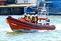
B class Atlantic 85 lifeboat of the RNLI, stationed in Poole Harbour
-
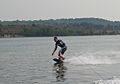
A wakeboarder riding down the Wareham channel


See also
 In Spanish: Puerto de Poole para niños
