Dorset Downs facts for kids
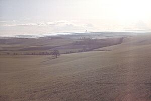
The Dorset Downs are a beautiful area of chalk hills in the middle of Dorset, a county in southwest England. These downs are part of a much bigger chain of chalk hills that stretches across southern England. This chain includes famous places like Salisbury Plain and the South Downs.
Contents
Exploring the Dorset Downs
Where are the Dorset Downs?
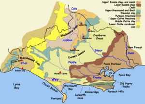
The Dorset Downs have clear boundaries. To the north, a steep slope called a scarp face drops down into the Blackmore Vale. This is a large valley made of clay and limestone.
To the east, the downs were once connected to Cranborne Chase. But the River Stour now flows between them. This river valley is where the town of Blandford Forum is located. It forms the eastern edge of the downs.
From the northern scarp, the hills gently slope southwards. The chalk then goes beneath sandy areas called Bagshot Beds. These form the heathlands between Dorchester and Wareham.
South of the River Frome, the chalk appears again in a narrower strip. This forms the coastal cliffs east of Weymouth. Further east, it creates the steep ridge of the Purbeck Hills. This southern strip of chalk is sometimes called the South Dorset Downs or South Dorset Ridgeway. It continues west behind Weymouth and joins the main downs at Eggardon Hill. In the west, the chalk dips under a type of rock called marl.
What is the land like?
The Dorset Downs, along with Cranborne Chase, are part of a special area. It's called National Character Area 134 by Natural England. This is the UK government's group that advises on nature. In Dorset, this area is next to the Dorset Heaths and Weymouth Lowlands to the south. It's also next to the Marshwood and Powerstock Vales to the west and the Blackmore Vale to the north.
Most of the land on the downs is used for farming. Farmers grow crops on arable land. There are also many woodlands and areas of calcareous grassland. This special type of grassland is growing. Farmers are encouraged to set aside land for it with government help.
Chalk is a rough rock, but it's great at holding water. The Dorset Downs have a large amount of water stored underground. This acts like a natural reservoir for drinking water for much of the county. Because of this, there are many seasonal rivers. These are called winterbournes. They only flow when the underground water level is high enough.
Hills of the Dorset Downs
The Dorset Downs are home to many hills. Here are some of the most well-known:
- Bulbarrow Hill (274 meters): This is the highest hill in the Downs. It's also home to an ancient fort called Rawlsbury camp.
- Telegraph Hill (267 meters)
- Lyscombe Hill (262 meters)
- Watts Hill (261 meters)
- Bell Hill (258 meters)
- Eggardon Hill (252 meters): This hill marks the western end of the downs.
- Toller Down (252 meters)
- Ball Hill (251 meters)
- Dogbury Hill (248 meters)
- Beaminster Down (244 meters)
- Shillingstone Hill (223 meters): This hill has many trees and a large quarry.
- Rampisham Down (219 meters)
- Hambledon Hill (192 meters) and Hod Hill (143 meters): These two hills are part of Cranborne Chase. They are separated from the main Downs by the River Stour.
Animals of the Downs
The downs are the original home of the Dorset Down sheep. This special breed of sheep is well-suited to living on these chalk hills.
Cool Places to Visit
There are many interesting places to see in and around the Dorset Downs:
- Blandford Forest: A great place for walks and exploring nature.
- Cerne valley: This valley is famous for the Cerne Abbas Giant. This is a huge ancient figure carved into the chalk hillside.
- Dorsetshire Gap: A very steep and interesting valley.
- Milton Abbas: An 18th-century village that was carefully planned. It also has a museum.
- Minterne Magna: Here you can find a beautiful garden with many Rhododendron flowers at Minterne House.
- Nettlecombe Tout: An ancient hill fort.
- Ringmoor: An old settlement and field system, showing how people lived long ago.
See also
 In Spanish: Dorset Downs para niños
 | Aurelia Browder |
 | Nannie Helen Burroughs |
 | Michelle Alexander |


